
 Cart
CartAddress Search
Results for "Latitude 29.9551703, Longitude -90.0672734"
View these maps overlayed on top of a modern map. You must be a member and logged in to use this feature.
Purchase a series of maps or images documenting the environmental or land use history of this location.
 A variety of printed products can be purchased by clicking on each individual map in the results below.
Click on any of the maps below to view a large, zoomable map.
 |
New Orleans 1720 Bird's Eye View 17x23 New Orleans 1720 Bird's Eye View show address on this map |
Jeffreys, Thomas | 1720 |
 |
New Orleans 1845 New Orleans 1845 show address on this map |
Mollhausen, Balduin | 1845 |
 |
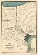
New Orleans 1863 City Approaches New Orleans 1863 City Approaches show address on this map |
Department of the Gulf | 1863 |
 |
New Orleans from 1864 Mitchell Plate New Orleans from 1864 Mitchell Plate show address on this map |
Historic Map Works | 1864 |
 |
New Orleans 1798 Drawn in 1875 New Orleans 1798 Drawn in 1875 show address on this map |
Trudeau, Charles Laveau | 1875 |
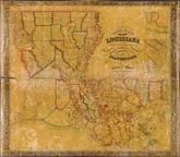 |
Louisiana 1848 State Map with Landowner Names 43x49 Louisiana 1848 State Map with Landowner Names show address on this map |
La Tourrette, John | 1848 |
 |
Louisiana 1853 State Map with Landowner Names 43x46 Louisiana 1853 State Map with Landowner Names show address on this map |
La Tourrette, John | 1853 |
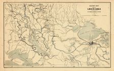 |
New Orleans 1863 Louisiana Military Map New Orleans 1863 Louisiana Military Map show address on this map |
A. D. Bache | 1863 |
 |
Mississippi Wells County 1881 show address on this map |
H.H. Hardesty | 1881 |
 |
United States Map Winnebago County and Boone County 1886 show address on this map |
H. R. Page & Co. | 1886 |
 |
Land Survey of the United States Cass County 1893 show address on this map |
D.W. Ensign & Co. | 1893 |
 |
The World Map with Principal Cities of the Old World Fillmore County 1896 show address on this map |
Geo. A. Ogle & Co. | 1896 |
 |
United States Map Genesee County 1899 show address on this map |
Homer A. Day | 1899 |
 |
World Map Rooks County 1904 to 1905 show address on this map |
Geo. A. Ogle & Co. | 1904 |
 |
United States Map Waushara County 1906c show address on this map |
C.A. McIntyre and C.H. Terril | 1906c |
 |
World Map Guthrie County 1917c show address on this map |
Kenyon Company | 1917c |