Click on any of the maps below to view a large, zoomable map.
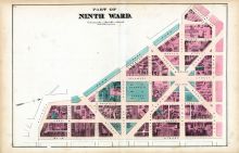 |
Ninth Ward 002
Buffalo 1872
show address on this map
|
G. M. Hopkins & Co. |
1872 |
 |
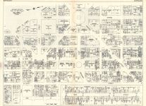
Plate 034 - Tax Districts I - I and II
Buffalo 1915 Vol 2
show address on this map
|
Century Atlas |
1915 |
 |
Buffalo
New York 1950c Nirenstein City Maps
show address on this map
|
Nirenstein |
1950 |
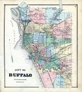 |
Buffalo City 1
Erie County 1866
show address on this map
|
Stone and Stewart |
1866 |
 |
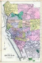
Buffalo - City
Erie County 1880
show address on this map
|
F. W. Beers & Co. |
1880 |
 |
Buffalo City - Ward Map
Erie County 1909
show address on this map
|
Century Map Co. |
1909 |
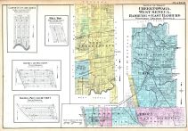 |
Cheektowaga Town 2, West Seneca Town 3, Hamburg Town, East Hamburg Town
Buffalo 1915 Vol 3 Suburban
show address on this map
|
Century Atlas |
1915 |
 |
Buffalo 1850 to 1899 - 04x069.3
Buffalo 1850 to 1899 - 04x069.3
show address on this map
|
Charles Magnus |
Unattributed |
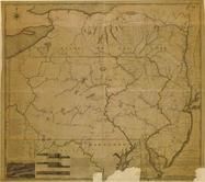 |
Pennsylvania 1791c - APSdigobj3529
Pennsylvania 1791c
show address on this map
|
Adlum, John, 1759-1836; Wallis, John |
1791c |
 |
Pennsylvania 1807 including neighboring states - APSdigobj3463
Pennsylvania 1807 including neighboring states
show address on this map
|
Pursh, Frederick, 1774-1820 |
1807 |
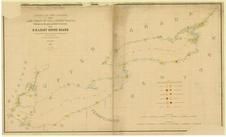 |
Lake Ontario - Lake Erie - Lake Champlain 1861 Lighthouse Charts - APSdigobj3543_001
Lake Ontario - Lake Erie - Lake Champlain 1861 Lighthouse Charts
show address on this map
|
Meade, George Gordon, 1815-1872 |
1861 |
 |
New York, New Hampshire, Vermont 1864 Mitchell Plate
New York, New Hampshire, Vermont 1864 Mitchell Plate
show address on this map
|
S. Augustus Mitchell |
1864 |
 |
Index Map
Erie County 1866
show address on this map
|
Stone and Stewart |
1866 |
 |
British America
Wells County 1881
show address on this map
|
H.H. Hardesty |
1881 |
 |
United States Map
Winnebago County and Boone County 1886
show address on this map
|
H. R. Page & Co. |
1886 |
 |
Land Survey of the United States
Cass County 1893
show address on this map
|
D.W. Ensign & Co. |
1893 |
 |
The World Map with Principal Cities of the Old World
Fillmore County 1896
show address on this map
|
Geo. A. Ogle & Co. |
1896 |
 |
United States Map
Genesee County 1899
show address on this map
|
Homer A. Day |
1899 |
 |
World Map
Rooks County 1904 to 1905
show address on this map
|
Geo. A. Ogle & Co. |
1904 |
 |
United States Map
Waushara County 1906c
show address on this map
|
C.A. McIntyre and C.H. Terril |
1906c |
 |
Erie County Map
Erie County 1909
show address on this map
|
Century Map Co. |
1909 |
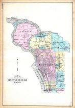 |
Outline Map of Greater Buffalo
Buffalo 1915 Vol 3 Suburban
show address on this map
|
Century Atlas |
1915 |
 |
World Map
Guthrie County 1917c
show address on this map
|
Kenyon Company |
1917c |
 |
Erie County Map
Erie County 1940
show address on this map
|
Rural Surveys Inc. |
1940 |

 Cart
Cart A variety of printed products can be purchased by clicking on each individual map in the results below.