Address Search
Results for "Latitude 43.007426, Longitude -84.371741"
View these maps overlayed on top of a modern map. You must be a member and logged in to use this feature.
Purchase a series of maps or images documenting the environmental or land use history of this location.

A variety of printed products can be purchased by clicking on each individual map in the results below.
Click on any of the maps below to view a large, zoomable map.
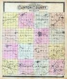 |
Clinton County Outline Map
Clinton County 1896
show address on this map
|
Geo. A. Ogle & Co. |
1896 |
 |
Ovid Township, Shepardsville, Jessie, Rochester Colony, Maple River
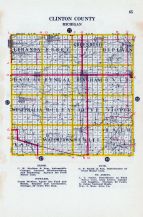
Clinton County 1915
show address on this map
|
Geo. A. Ogle and Co. |
1915 |
 |
Ovid Township, Shepardsville, Maple River
Clinton County 1930c
show address on this map
|
W. W. Hixson & Co. |
1930c |
 |
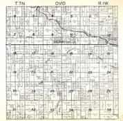
Ovid T7N-R1W
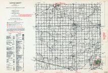
Clinton County 1968
show address on this map
|
Directory Service Company |
1968 |
 |
Ovid T7N-R1W
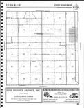
Clinton County 2003
show address on this map
|
Farm and Home Publishers, LTD |
2003 |
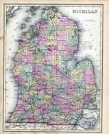 |
Michigan State Map
Kalamazoo County 1873 Published by F. W. Beers
show address on this map
|
F. W. Beers & Co. |
1873 |
 |
British America
Wells County 1881
show address on this map
|
H.H. Hardesty |
1881 |
 |
United States Map
Winnebago County and Boone County 1886
show address on this map
|
H. R. Page & Co. |
1886 |
 |
Land Survey of the United States
Cass County 1893
show address on this map
|
D.W. Ensign & Co. |
1893 |
 |
The World Map with Principal Cities of the Old World
Fillmore County 1896
show address on this map
|
Geo. A. Ogle & Co. |
1896 |
 |
United States Map
Genesee County 1899
show address on this map
|
Homer A. Day |
1899 |
 |
World Map
Rooks County 1904 to 1905
show address on this map
|
Geo. A. Ogle & Co. |
1904 |
 |
United States Map
Waushara County 1906c
show address on this map
|
C.A. McIntyre and C.H. Terril |
1906c |
 |
Clinton County Outline Map
Clinton County 1915
show address on this map
|
Geo. A. Ogle and Co. |
1915 |
 |
Clinton County
Michigan State Atlas 1916 Automobile and Sportsmens Guide
show address on this map
|
B. F. Bowen Co. |
1916 |
 |
World Map
Guthrie County 1917c
show address on this map
|
Kenyon Company |
1917c |
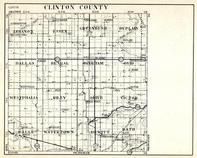 |
Clinton County, Lebanon, Essex, Greenbush, Duplain, Dallas, Bengal, Bingham, Ovid, Westphalia, Riley, Olive, Victor
Michigan State Atlas 1930c
show address on this map
|
W. W. Hixson & Co. |
1930c |
 |
Clinton County
Michigan State Atlas 1955
show address on this map
|
Michigan Department of Conservation |
1955 |

 Cart
Cart