Address Search
Results for "Latitude 48.52054, Longitude -122.614105"
View these maps overlayed on top of a modern map. You must be a member and logged in to use this feature.
Purchase a series of maps or images documenting the environmental or land use history of this location.

A variety of printed products can be purchased by clicking on each individual map in the results below.
Click on any of the maps below to view a large, zoomable map.
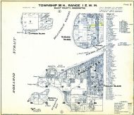 |
Page 003 - Anacortes, Fidalgo Island, Guemes, Cypress Island, Burrows Island, Allan Island, Green Pt., Shannon Pr., Fidalgo Head
Skagit County 1941
show address on this map
|
Chas F. Metsker |
1941 |
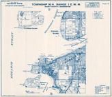 |
Township 35 N., Range 1 E., Guemes Island, Burrows Island, Anacortes
Skagit County 1972
show address on this map
|
Metsker Maps |
1972 |
 |
British America
Wells County 1881
show address on this map
|
H.H. Hardesty |
1881 |
 |
United States Map
Winnebago County and Boone County 1886
show address on this map
|
H. R. Page & Co. |
1886 |
 |
Land Survey of the United States
Cass County 1893
show address on this map
|
D.W. Ensign & Co. |
1893 |
 |
The World Map with Principal Cities of the Old World
Fillmore County 1896
show address on this map
|
Geo. A. Ogle & Co. |
1896 |
 |
United States Map
Genesee County 1899
show address on this map
|
Homer A. Day |
1899 |
 |
General Map of Adjacent Parts of North America And Asia
Alaska Boundary Tribunal Atlas 1903 Maps from 1795 to 1903
show address on this map
|
Govt. Publication |
1903 |
 |
World Map
Rooks County 1904 to 1905
show address on this map
|
Geo. A. Ogle & Co. |
1904 |
 |
United States Map
Waushara County 1906c
show address on this map
|
C.A. McIntyre and C.H. Terril |
1906c |
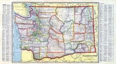 |
Washington State Map
Klickitat County 1913 Version 1
show address on this map
|
Geo. A. Ogle & Co. |
1913 |
 |
World Map
Guthrie County 1917c
show address on this map
|
Kenyon Company |
1917c |
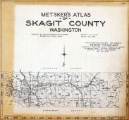 |
Title Page and Index Map
Skagit County 1925
show address on this map
|
Chas F. Metsker |
1925 |
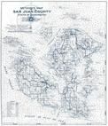 |
San Juan County 1949
San Juan County 1949 Wall Map
show address on this map
|
Thos. C. Metsker |
1949 |
 |
Skagit County 1959 Hand Revised 1960
Skagit County 1959 Hand Revised 1960
show address on this map
|
Thos. C. Metsker |
1959 |
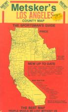 |
Envelope Front - Title
Los Angeles County 1975c
show address on this map
|
Metsker Maps |
1975 |
 |
Skagit County 1980 to 1996 Tracing
Skagit County 1980 to 1996
show address on this map
|
Metsker Maps |
1980 |

 Cart
Cart