 |
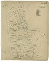
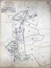
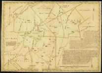
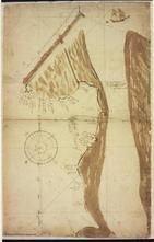
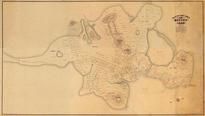
Sandifiel, Montville, Mill Rivertown, New Boston Town, New Boston West |
Berkshire County 1876 |
Frederick W. Beers |
1876 |
 |
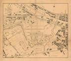
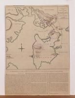
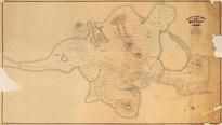
Sandisfield, Montville, New Boston West, New Boston, Sandisfield South |
Berkshire County 1904 |
Barnes & Farnham |
1904 |
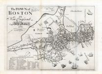 |
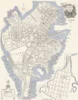
Boston 1722 Captain John Bonner Survey Reprinted 1867 |
Boston 1722 Captain John Bonner Survey Reprinted 1867 |
Captain John Bonner |
1722 |
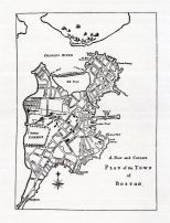 |
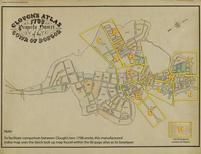
Boston 1789 Norman Survey |
Boston 1789 Norman Survey |
Norman |
1789 |
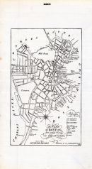 |
Boston 1803 Carleton Survey |
Boston 1803 Carleton Survey |
Ofgood Carleton |
1803 |
 |
Boston 1789 Normans Survey - Plate 283 |
Boston 1819 and 1820 Street-Lines |
John Graves Hale |
1819 |
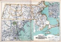 |
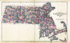
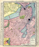
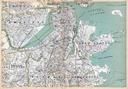
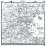
Massachusetts State Map and Boston Insert |
Malden 1897 Published by Walker |
Geo. H. Walker & Co. |
1897 |
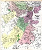 |
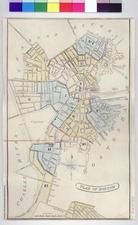
Boston City |
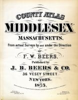
Middlesex County 1875 |
F. W. Beers |
1875 |
 |
Boston 1814 J. G. Hale Survey |
Boston 1814 J. G. Hale Survey |
John Graves Hale |
1814 |
 |
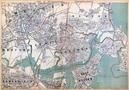
State Map Massachusetts and Boston Map |
Abington and Rockland 1874 |
Sherman W. A. and Howland C. W. |
1874 |
 |
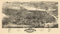
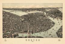
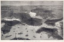
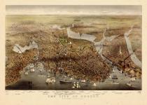
Boston 1877 Bird's Eye View 24x30 |
Boston 1877 Bird's Eye View |
J. Bachman |
1877 |
 |
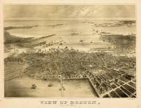
Boston 1870 Bird's Eye View 24x36 |
Boston 1870 Bird's Eye View |
T. Schulman |
1870 |
 |
Boston 1902 Bird's Eye View 17x24 |
Boston 1902 Bird's Eye View |
Beach and Clarridge |
1902 |
 |
Boston and Environs 1905 Bird's Eye View 17x23 |
Boston and Environs 1905 Bird's Eye View |
George H. Walker |
1905 |
 |
Boston 1764 Bellin |
Boston 1764 Bellin |
Jacques-Nicolas Bellin |
1764 |
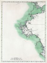 |
Boston Harbor Chart 1790 Des Barres |
Boston Harbor Chart 1790 Des Barres |
Des Barres |
1790 |
 |
Boston Harbor 1930c Bird's Eye View - Boston to Cape Cod |
Boston Harbor 1930c Bird's Eye View - Boston to Cape Cod |
Union News Company |
1930 |
 |
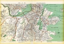
Metropolitan District Map - Pages 62 and 63, Waltham, Newton, Boston, Brookline, Watertown |
Massachusetts State Atlas 1891 |
Geo. H. Walker & Co. |
1891 |
 |
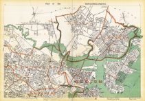
Metropolitan District Map - Pages 66 and 67, Newton, Boston, Brookline |
Massachusetts State Atlas 1891 |
Geo. H. Walker & Co. |
1891 |
 |
Metropolitan District Map - Pages 70 and 71, Brookline, Roxbury, Boston, Dorchester, Hyde Park, Milton, Quincy |
Massachusetts State Atlas 1891 |
Geo. H. Walker & Co. |
1891 |
 |
Metropolitan District Map - Pages 74 and 75, Boston, Cambridge, Brookline, Roxbury, Brighton |
Massachusetts State Atlas 1891 |
Geo. H. Walker & Co. |
1891 |
 |
Metropolitan District Map - Pages 78 and 79, Boston, Medford, Cambridge, Somerville, Everett, Chelsea |
Massachusetts State Atlas 1891 |
Geo. H. Walker & Co. |
1891 |
 |
Plate 004, Middlesex, Boston, Norfolk, Suffolk, Worcester |
Massachusetts State Atlas 1891 |
Geo. H. Walker & Co. |
1891 |
 |
Plate 005, Boston, Suffolk, Norfolk, Plymouth, Saugus, Marblehead, Cohasset, Quincy |
Massachusetts State Atlas 1891 |
Geo. H. Walker & Co. |
1891 |
 |
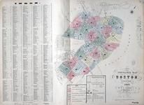
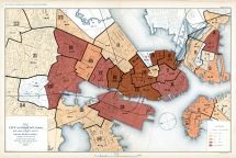
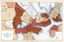
Boston - City Page 001 - Relative Death Rates in Different Districts |
Boston 1895 Vital Statistics from 1884 to 1890 |
Department of the Interior |
1895 |
 |
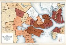
Boston - City Page 002 - Relative Death Rates of Under 5 Years of Age |
Boston 1895 Vital Statistics from 1884 to 1890 |
Department of the Interior |
1895 |
 |
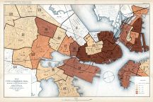
Boston - City Page 003 - Consumption |
Boston 1895 Vital Statistics from 1884 to 1890 |
Department of the Interior |
1895 |
 |
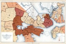
Boston - City Page 004 - Pneumonia |
Boston 1895 Vital Statistics from 1884 to 1890 |
Department of the Interior |
1895 |
 |
Boston - City Page 005 - Diptheria and Croup |
Boston 1895 Vital Statistics from 1884 to 1890 |
Department of the Interior |
1895 |
 |
Boston - City Page 006 - Diarrheal Diseases |
Boston 1895 Vital Statistics from 1884 to 1890 |
Department of the Interior |
1895 |
 |
Boston 1864 Mitchell Plate |
Boston 1864 Mitchell Plate |
S. Augustus Mitchell |
1864 |
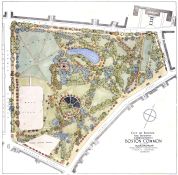 |
Boston Common 1929 Landscape Survey |
Boston Common 1929 Landscape Survey |
Arthur A. Shurtleff |
1929 |
 |
Boston 191x |
Boston 191x |
Rand McNally |
191x |
 |
Boston 1901 |
Boston 1901 |
Rand McNally |
1901 |
 |
Boston 1908 |
Boston 1908 |
Historic Map Works |
1908 |
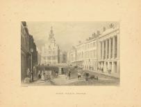 |
Boston 1840 View of State Street |
Boston 1840 View of State Street |
W. H. Bartlett |
1840 |
 |
Boston 1899 Bird's Eye View 24x35 |
Boston 1899 Bird's Eye View |
E. A. Downs and Geo. H. Walker & Co. Lith |
1899 |
 |
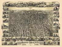
Boston 1888 Bird's Eye View of the Highlands 24x30 |
Boston 1888 Bird's Eye View of the Highlands |
O.H. Bailey & Co. |
1888 |
 |
Boston 1880 Bird's Eye View 24x41 |
Boston 1880 Bird's Eye View |
H.H. Rowley & Co. |
1880 |
 |
Boston 1879 Bird's Eye View 24x36 |
Boston 1879 Bird's Eye View |
O.H. Bailey & J.C. Hazen |
1879 |
 |
Boston 1873 Bird's Eye View 24x33 |
Boston 1873 Bird's Eye View |
Parons & Atwater |
1873 |
 |
Boston 1870 Bird's Eye View on July 4th 24x31 |
Boston 1870 Bird's Eye View on July 4th |
F. Fuchs |
1870 |
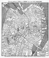 |
Boston 1914 Business Section Map |
Boston 1914 Business Section from Boston 1919 Street Directory |
Sampson and Murdock Co. |
1914 |
 |
Boston 1922 High Pressure Fire Service Map |
Boston 1922 High Pressure Fire Service Map |
Boston Board of Fire Underwriters |
1922 |
 |
Cambridge, Charlestown, Boston, Dorchester, Roxbury, Brookline |
Massachusetts State Atlas 1900 |
Geo. H. Walker & Co. |
1900 |
 |
Medford, Malden, Revere, Chelsea, Somerville, East Boston, Charlestown |
Massachusetts State Atlas 1904 |
Geo. H. Walker & Co. |
1904 |
 |
Melrose, wyoming, Boston Rock |
Massachusetts State Atlas 1904 |
Geo. H. Walker & Co. |
1904 |
 |
Somerville, Charlestown, Brookline, roxbury, Dorchester, South Boston |
Massachusetts State Atlas 1904 |
Geo. H. Walker & Co. |
1904 |
 |
Cambridge, Brighton, Brookline, Roxbury, Dorchester, South Boston |
Massachusetts State Atlas 1909 |
Walker Lithograph & Publishing Co. |
1909 |
 |
Chlesea, Revere, Malden, Charlestown, East Boston, Winthrop |
Massachusetts State Atlas 1909 |
Walker Lithograph & Publishing Co. |
1909 |
 |
Melrose, Boston Rock, Wyoming Cemetery |
Massachusetts State Atlas 1909 |
Walker Lithograph & Publishing Co. |
1909 |
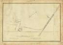 |
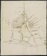
Page 103, Boston and Lowell Rail Road 1869 |
Somerville and Surrounds 1843 to 1873 Survey Plans |
W. A. Mason |
1843 |
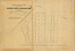 |
Page 104, Boston and Lowell Rail Road 1857 |
Somerville and Surrounds 1843 to 1873 Survey Plans |
W. A. Mason |
1843 |
 |
Boston 1722 Captain John Bonner Survey - Version B |
Boston 1722 Captain John Bonner Survey |
Captain John Bonner |
1722 |
 |
Boston 1722 Captain John Bonner Survey - Version A |
Boston 1722 Captain John Bonner Survey |
Captain John Bonner |
1722 |
 |
Boston 1872 Plan of the Burnt District |
Boston 1872 Plan of the Burnt District |
Thos S. Davis |
1872 |
 |
Boston 1878 Civil Engineers Sketch - Version A |
Boston 1878 Civil Engineers Sketch |
Office of Improved Sewerage |
1878 |
 |
Boston 1878 Civil Engineers Sketch - Version B |
Boston 1878 Civil Engineers Sketch |
Office of Improved Sewerage |
1878 |
 |
Boston 1902 Fenway and Back Bay |
Boston 1902 Fenway and Back Bay |
Fuller Whitney Surveys Corperation |
1902 |
 |
Boston 1902 Public Reservations and Parks |
Boston 1902 Public Reservations and Parks |
Metropolitan Park Commision |
1902 |
 |
Boston 1905 Bird's Eye View |
Boston 1905 Bird's Eye View |
F. D. Nichols Company |
1905 |
 |
Boston 1855 Copied 1865 South Cove - Present South Station and I93 & I90 Interchange |
Boston 1855 Copied 1865 South Cove - Present South Station and I93 & I90 Interchange |
Unattributed |
1855 |
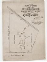 |
Cyrus Dupee 1889 Colby, Boston and Albany RR |
Allston 1890c Survey Plans |
Various from Perkins Collection |
1890c |
 |
John W. Hollis 1888 City of Boston School House Lot, Baldwin and Hollis |
Allston 1890c Survey Plans |
Various from Perkins Collection |
1890c |
 |
Boston Chrome Co. 1899 Plan A of Premises |
Arlington 1890c Survey Plans |
Various from Perkins Collection |
1890c |
 |
Boston Chrome Co. 1899 Plan B of Premises |
Arlington 1890c Survey Plans |
Various from Perkins Collection |
1890c |
 |
Boston Ice Co. premises at Fresh Pond 1890 |
Cambridge 1890c Survey Plans |
Various from Perkins Collection |
1890c |
 |
Notre Dame de Pitie Chuch 1920 Roman Catholic Archbiship of Boston |
Cambridge 1890c Survey Plans |
Various from Perkins Collection |
1890c |
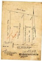 |
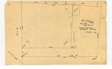
Caroline Brooks 1888 West Boston Bridge, Luke, Dalrymple, Coon, Horgan - Map 2 |
Cambridgeport 1890c Survey Plans |
Various from Perkins Collection |
1890c |
 |
Caroline Brooks 1888 West Boston Bridge, Luke, Dalrymple, Coon, Horgan - Map 1 |
Cambridgeport 1890c Survey Plans |
Various from Perkins Collection |
1890c |
 |
Cambridge St. Lots 1889 Boston & Albany Railroad - Copy 2 |
Cambridgeport 1890c Survey Plans |
Various from Perkins Collection |
1890c |
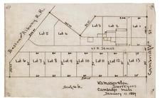 |
Cambridge St. Lots 1889 Boston & Albany Railroad - Copy 1 |
Cambridgeport 1890c Survey Plans |
Various from Perkins Collection |
1890c |
 |
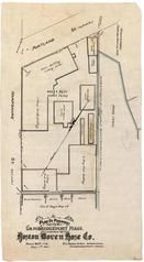
Boston Woven Hose Co. 1897 Geo. G. Page Box Co., Broad Canal |
Cambridgeport 1890c Survey Plans |
Various from Perkins Collection |
1890c |
 |
Boston Woven Hose Co. 1891 Geo. G. Page Box Co., Broad Canal |
Cambridgeport 1890c Survey Plans |
Various from Perkins Collection |
1890c |
 |
Boston Woven Hose Co. 1885 Factory Plan |
Cambridgeport 1890c Survey Plans |
Various from Perkins Collection |
1890c |
 |
Boston Woven Hose Co. 1886 Factory Plan |
Cambridgeport 1890c Survey Plans |
Various from Perkins Collection |
1890c |
 |
Boston Ice Co. 1890 |
Cambridgeport 1890c Survey Plans |
Various from Perkins Collection |
1890c |
 |
A. M. Perkins 1894 Adams St. and Boston Ave |
Medford 1890c Survey Plans |
Various from Perkins Collection |
1890c |
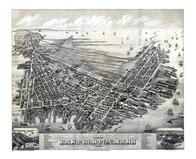 |
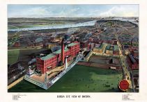
Boston 1879 East Boston Bird's Eye View |
Boston 1879 East Boston Bird's Eye View |
O.H. Bailey & Co. |
1879 |
 |
Boston 1850 to 1899 Bird's Eye View - 79x258.3 |
Boston 1850 to 1899 Bird's Eye View - 79x258.3 |
Charles Magnus |
Unattributed |
 |
Boston 1861 to 1865 Bird's Eye View - 81x290.1 |
Boston 1861 to 1865 Bird's Eye View - 81x290.1 |
Charles Magnus |
[1861-1865] |
 |
Boston 1714 Long Wharf MHS Digital Image 5095 |
Boston 1714 Long Wharf MHS Digital Image 5095 |
John Bonner |
1714 |
 |
Boston 1722 Captain John Bonner Survey reissued and updated in 1835 MHS Digital Image 5024 |
Boston 1722 Captain John Bonner Survey reissued and updated in 1835 MHS Digital Image 5024 |
Capt. John Bonner |
1722 |
 |
Boston 1722 Captain John Bonner Survey third state likely produced in 1725 MHS Digital Image 5023 |
Boston 1722 Captain John Bonner Survey third state likely produced in 1725 MHS Digital Image 5023 |
Capt. John Bonner |
1722 Likely 1725 |
 |
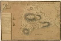
Boston 1775 Battle of Bunker Hill 17 June MHS Digital Image 4919 |
Boston 1775 Battle of Bunker Hill 17 June MHS Digital Image 4919 |
An officer on the spot |
1775 |
 |
Boston 1775 Battle of Bunker Hill 28 November MHS Digital Image 5057 |
Boston 1775 Battle of Bunker Hill 28 November MHS Digital Image 5057 |
S. Biggs |
1775 |
 |
Boston 1775 Recreated 1907 MHS Digital Image 5005 |
Boston 1775 Recreated 1907 MHS Digital Image 5005 |
Henry Pelham. Engraved in aqua tinta by Francis Jukes |
1907 |
 |
Boston 1776 MHS Digital Image 0096 |
Boston 1776 MHS Digital Image 0096 |
Richard Williams. Engrav?d by Jno. Lodge |
1776 |
 |
Boston 1787 MHS Digital Image 4968 |
Boston 1787 MHS Digital Image 4968 |
Jeremy Belknap |
1787 |
 |
Boston 1794 MHS Digital Image 5088 |
Boston 1794 MHS Digital Image 5088 |
Jeremy Belknap |
1794 |
 |
Boston 1814 MHS Digital Image 5112 |
Boston 1814 MHS Digital Image 5112 |
Benjamin Dearborn |
1814 |
 |
Boston 1825c MHS Digital Image 3516 |
Boston 1825c MHS Digital Image 3516 |
Unattributed |
1825c |
 |
Boston Harbor 1775 MHS Digital Image 5111 |
Boston Harbor 1775 MHS Digital Image 5111 |
Jeremy Belknap |
1775 |
 |
Boston Harbor 1776 MHS Digital Image 5249 |
Boston Harbor 1776 MHS Digital Image 5249 |
Unattributed |
1776 |
 |
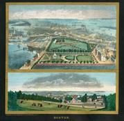
Boston 1852 Boston and Vicinity Wall Map with background |
Boston 1852 Boston and Vicinity Wall Map |
J. B. Shields |
1852 |
 |
Boston 1852 Boston and Vicinity Wall Map |
Boston 1852 Boston and Vicinity Wall Map |
J. B. Shields |
1852 |
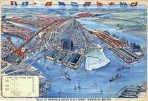 |
Boston 1905 Bird's Eye View of Boston's North End, Charlestown and Maine Railroad Export Terminals |
Boston 1905 Bird's Eye View of Boston's North End, Charlestown and Maine Railroad Export Terminals |
Geo. H. Walker & Co. |
1905 |
 |
Boston 1775 Battle of Bunker Hill - APSdigobj3453 |
Boston 1775 Battle of Bunker Hill |
De Berniere, Henry |
1775 |
 |
Boston Harbor 1777 - APSdigobj3523 |
Boston Harbor 1777 |
Pelham, Henry, 1695?-1754 |
1777 |
 |
Boston 1648 Created 1919 MHS Digital Image 5104 Version 1 Digitally Restored |
Boston 1648 Created 1919 MHS Digital Image 5104 |
Samuel Chester Clough |
1648 |
 |
Boston 1648 Created 1919 MHS Digital Image 5104 Version 2 |
Boston 1648 Created 1919 MHS Digital Image 5104 |
Samuel Chester Clough |
1648 |
 |
Boston 1676 Created 1920c MHS Digital Image 3850 |
Boston 1676 Created 1920c MHS Digital Image 3850 |
Samuel Chester Clough |
1676 |

 Cart
Cart