|
Brewster Town |
Barnstable County 1880 |
Geo. H. Walker & Co. |
1880 |
 |
Brewster Village West, Brewster Village East |
Barnstable County 1880 |
Geo. H. Walker & Co. |
1880 |
 |
Brewster Village |
Barnstable County 1880 |
Geo. H. Walker & Co. |
1880 |
 |
Dennis Town - Dennis South, Brewster Town - Brewster East |
Barnstable County 1905 |
Walker Lithograph & Publishing Co. |
1905 |
 |
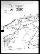
Brewster Town Index Map |
Barnstable County 1905 |
Walker Lithograph & Publishing Co. |
1905 |
 |
Brewster Town - Brewster Village, Brewster North |
Barnstable County 1905 |
Walker Lithograph & Publishing Co. |
1905 |
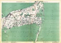 |
Plate 009, Cape Cod, Barnstable, Orleans, Brewster, Harwich, Chatham, Dennis, Yarmouth |
Massachusetts State Atlas 1891 |
Geo. H. Walker & Co. |
1891 |
 |
Plate 039 Right - Brewster Village |
Barnstable County 1910 |
Walker Lithograph and Publishing Company |
1910 |
 |
Plate 039 Left - Brewster Village |
Barnstable County 1910 |
Walker Lithograph and Publishing Company |
1910 |
 |
Plate 034 Right - South Dennis, East Brewster |
Barnstable County 1910 |
Walker Lithograph and Publishing Company |
1910 |
 |
Plate 034 Left - South Dennis, East Brewster |
Barnstable County 1910 |
Walker Lithograph and Publishing Company |
1910 |
 |
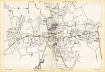
Index Map and Plate 038 Right - Brewster |
Barnstable County 1910 |
Walker Lithograph and Publishing Company |
1910 |
 |
Index Map and Plate 038 Left - Brewster |
Barnstable County 1910 |
Walker Lithograph and Publishing Company |
1910 |
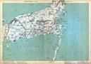 |
Plate 009 - Yarmouth, Chatham, Harwich, Brewster, Dennis |
Massachusetts State Atlas 1904 |
Geo. H. Walker & Co. |
1904 |
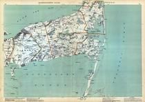 |
Plate 009 - Yarmouth, Harwich, Chatham, Brewster |
Massachusetts State Atlas 1909 |
Walker Lithograph & Publishing Co. |
1909 |
 |
Craigie Estate 1851 Little, Carpenter, Brewster |
Cambridge 1890c Survey Plans |
Various from Perkins Collection |
1890c |
 |
John Brewster 1888 Read |
Cambridge 1890c Survey Plans |
Various from Perkins Collection |
1890c |
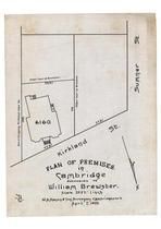 |
William Brewster 1899 Kirkland Land Co |
Cambridge 1890c Survey Plans |
Various from Perkins Collection |
1890c |

 Cart
Cart