 |
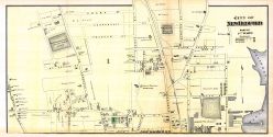
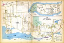
New Bedford City - Ward 1 |
Bristol County 1871 |
F. W. Beers & Co. |
1871 |
 |
New Bedford City - Wards 1 2 |
Bristol County 1871 |
F. W. Beers & Co. |
1871 |
 |
New Bedford City - Wards 2 3 4 |
Bristol County 1871 |
F. W. Beers & Co. |
1871 |
 |
New Bedford City - Wards 4 5 6 |
Bristol County 1871 |
F. W. Beers & Co. |
1871 |
 |
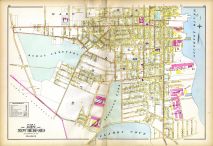
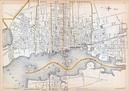
New Bedford City |
Bristol County 1871 |
F. W. Beers & Co. |
1871 |
 |
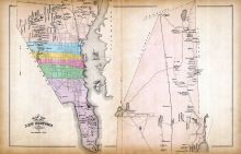
New Bedford, Acushnet Town, Cannonville |
Bristol County 1871 |
F. W. Beers & Co. |
1871 |
 |
New Bedford Business Directory |
Bristol County 1871 |
F. W. Beers & Co. |
1871 |
 |
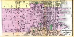
New Bedford City 1 |
Bristol County 1895 |
Everts & Richards |
1895 |
 |
New Bedford City 2 |
Bristol County 1895 |
Everts & Richards |
1895 |
 |
New Bedford City 3 |
Bristol County 1895 |
Everts & Richards |
1895 |
 |
New Bedford City 4 |
Bristol County 1895 |
Everts & Richards |
1895 |
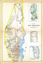 |
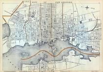
New Bedford City |
Bristol County 1895 |
Everts & Richards |
1895 |
 |
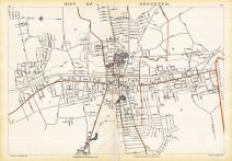
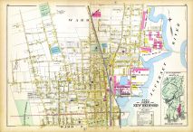
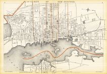
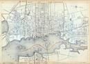
New Bedford City Map |
New Bedford 1881 |
Geo. H. Walker & Co. |
1881 |
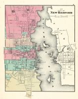 |
New Bedford City |
Massachusetts State Atlas 1871 |
Stedman, Brown and Lyon |
1871 |
 |
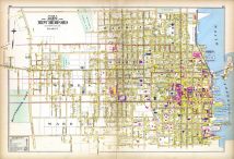
New Bedford City |
Massachusetts State Atlas 1891 |
Geo. H. Walker & Co. |
1891 |
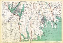 |
Plate 013, Bristol, Plymouth, Swansea, Fall River, Rochester, New Bedford, Westport |
Massachusetts State Atlas 1891 |
Geo. H. Walker & Co. |
1891 |
 |
New Bedford - Street Index |
Bristol County 1944 Street Index |
Harry D. Lord's |
1944 |
 |
New Bedford - South |
Bristol County 1944 Street Index |
Harry D. Lord's |
1944 |
 |
New Bedford - North |
Bristol County 1944 Street Index |
Harry D. Lord's |
1944 |
 |
New Bedford, Acushnet River |
Massachusetts State Atlas 1900 |
Geo. H. Walker & Co. |
1900 |
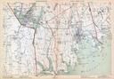 |
Plate 013 - Westport, Bristol, New Bedford, Fairhaven, Dartmouth |
Massachusetts State Atlas 1900 |
Geo. H. Walker & Co. |
1900 |
 |
New Bedford, Acushnet River, Dartmouth |
Massachusetts State Atlas 1904 |
Geo. H. Walker & Co. |
1904 |
 |
New Bedford, Acushnet River |
Massachusetts State Atlas 1909 |
Walker Lithograph & Publishing Co. |
1909 |
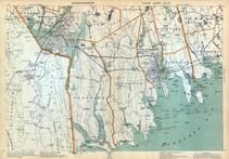 |
Plate 013 - Somerset, New Bedford, Bristol, Middletown, Swansea, Acushnet, Plymouth |
Massachusetts State Atlas 1909 |
Walker Lithograph & Publishing Co. |
1909 |

 Cart
Cart