|
Grand Rapids 1868 Bird's Eye View 17x26 |
Grand Rapids 1868 Bird's Eye View |
Ruger, A. |
1868 |
 |
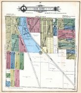
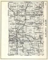
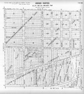
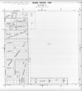
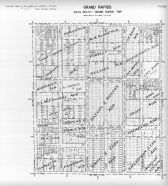
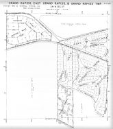
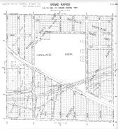
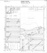
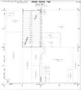
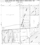
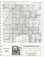
Grand Rapids Township |
Ottawa and Kent Counties 1876 |
H. Belden and Co. |
1876 |
 |
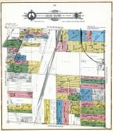
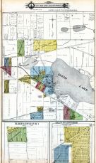
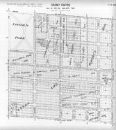
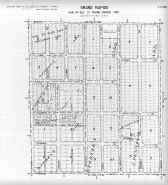
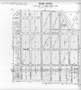
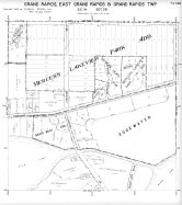
Grand Rapids Township |
Kent County 1876 |
H. Belden and Co. |
1876 |
 |
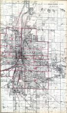
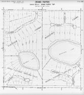
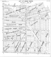
Index Map - Grand Rapids - City 1 |
Kent County and Grand Rapids 1894 |
R. L. Pol and Co. |
1894 |
 |
Index Map - Grand Rapids - City 2 |
Kent County and Grand Rapids 1894 |
R. L. Pol and Co. |
1894 |
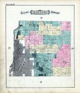 |
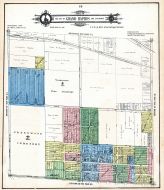
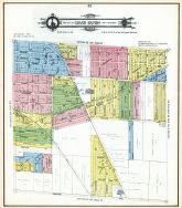
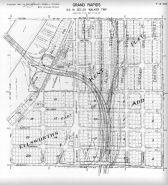
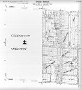
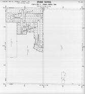
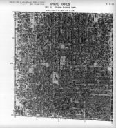
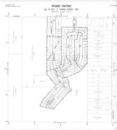
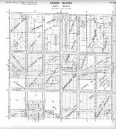
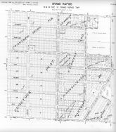
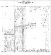
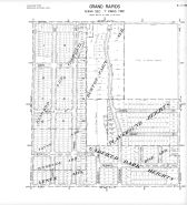
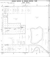
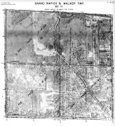
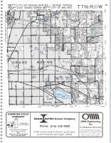
Plate 054 - Grand Rapids Township |
Kent County and Grand Rapids 1894 |
R. L. Pol and Co. |
1894 |
 |
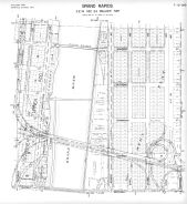
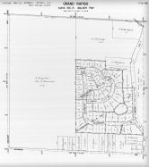
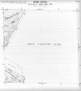
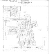
Grand Rapids Brewing Co |
Kent County and Grand Rapids 1894 |
R. L. Pol and Co. |
1894 |
 |
Grand Rapids Brewing Co |
Kent County and Grand Rapids 1894 |
R. L. Pol and Co. |
1894 |
 |
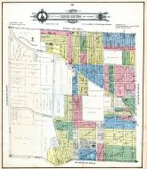
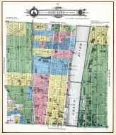
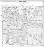
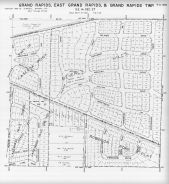
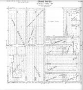
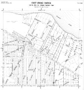
Grand Rapids City - Page 17 |
Kent County 1907 |
Geo. A. Ogle and Co. |
1907 |
 |
Grand Rapids City - Page 18 |
Kent County 1907 |
Geo. A. Ogle and Co. |
1907 |
 |
Grand Rapids City - Page 19 |
Kent County 1907 |
Geo. A. Ogle and Co. |
1907 |
 |
Grand Rapids City - Page 20 |
Kent County 1907 |
Geo. A. Ogle and Co. |
1907 |
 |
Grand Rapids City - Page 21 |
Kent County 1907 |
Geo. A. Ogle and Co. |
1907 |
 |
Grand Rapids City - Page 22 |
Kent County 1907 |
Geo. A. Ogle and Co. |
1907 |
 |
Grand Rapids City - Page 23 |
Kent County 1907 |
Geo. A. Ogle and Co. |
1907 |
 |
Grand Rapids City - Page 24 |
Kent County 1907 |
Geo. A. Ogle and Co. |
1907 |
 |
Grand Rapids City - Page 25 |
Kent County 1907 |
Geo. A. Ogle and Co. |
1907 |
 |
Grand Rapids City - Page 26 |
Kent County 1907 |
Geo. A. Ogle and Co. |
1907 |
 |
Grand Rapids City - Page 27 |
Kent County 1907 |
Geo. A. Ogle and Co. |
1907 |
 |
Grand Rapids City - Page 28 |
Kent County 1907 |
Geo. A. Ogle and Co. |
1907 |
 |
Grand Rapids City - Page 29 |
Kent County 1907 |
Geo. A. Ogle and Co. |
1907 |
 |
Grand Rapids City - Page 30 |
Kent County 1907 |
Geo. A. Ogle and Co. |
1907 |
 |
Grand Rapids City - Page 31 |
Kent County 1907 |
Geo. A. Ogle and Co. |
1907 |
 |
Grand Rapids City - Page 32 |
Kent County 1907 |
Geo. A. Ogle and Co. |
1907 |
 |
Grand Rapids City - Page 33 |
Kent County 1907 |
Geo. A. Ogle and Co. |
1907 |
 |
Grand Rapids City - Page 34 |
Kent County 1907 |
Geo. A. Ogle and Co. |
1907 |
 |
Grand Rapids City - Page 35 |
Kent County 1907 |
Geo. A. Ogle and Co. |
1907 |
 |
Grand Rapids City - Page 36 |
Kent County 1907 |
Geo. A. Ogle and Co. |
1907 |
 |
Grand Rapids City - Page 37 |
Kent County 1907 |
Geo. A. Ogle and Co. |
1907 |
 |
Grand Rapids City - Page 38 |
Kent County 1907 |
Geo. A. Ogle and Co. |
1907 |
 |
Grand Rapids City - Page 39 |
Kent County 1907 |
Geo. A. Ogle and Co. |
1907 |
 |
Grand Rapids City - Page 40 |
Kent County 1907 |
Geo. A. Ogle and Co. |
1907 |
 |
Grand Rapids City - Page 41 |
Kent County 1907 |
Geo. A. Ogle and Co. |
1907 |
 |
Grand Rapids City - Page 42 |
Kent County 1907 |
Geo. A. Ogle and Co. |
1907 |
 |
Grand Rapids City - Page 44 |
Kent County 1907 |
Geo. A. Ogle and Co. |
1907 |
 |
Grand Rapids City - Page 45 |
Kent County 1907 |
Geo. A. Ogle and Co. |
1907 |
 |
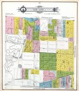
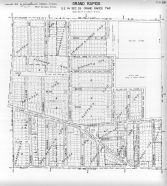
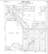
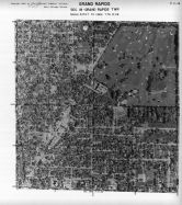
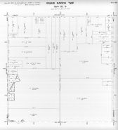
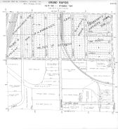
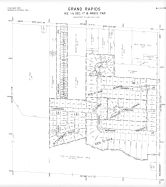
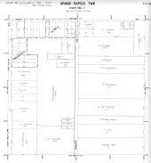
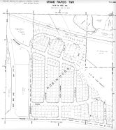
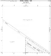
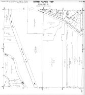
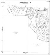
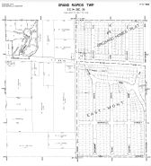
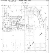
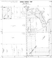
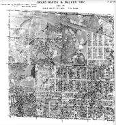
Grand Rapids Township |
Kent County 1907 |
Geo. A. Ogle and Co. |
1907 |
 |
Index Map - Grand Rapids City 1 |
Kent County 1907 |
Geo. A. Ogle and Co. |
1907 |
 |
Index Map - Grand Rapids City 2 |
Kent County 1907 |
Geo. A. Ogle and Co. |
1907 |
 |
Heft, Grand Rapids Engraving, Otte, Kraft, Minor, Palace Livery, Heyman, Allen, Mathews, Wedgwood, Miller, Hotel Pantlind |
Kent County 1907 |
Geo. A. Ogle and Co. |
1907 |
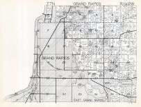 |
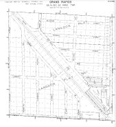
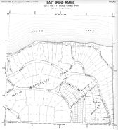
Grand Rapids Township, Lamberton, East Grand Rapids |
Kent County 1920c |
W.W. Hixson & Co. |
1920 |
 |
Paris Township, Grand Rapids, Ponce de Leon, Crosby, Bowen Sta. |
Kent County 1920c |
W.W. Hixson & Co. |
1920 |
 |
Walker Township, Grand Rapids, Kinney Sta. |
Kent County 1920c |
W.W. Hixson & Co. |
1920 |
 |
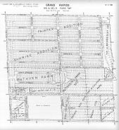
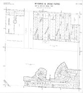
Wyoming Township, Grandville, Ivanrest, Grand Rapids, Beverly, Barendsenville |
Kent County 1920c |
W.W. Hixson & Co. |
1920 |
 |
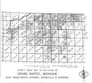
Kent County, Tyrone, Solon, Nelson, Spencer, Sparta, Algoma, Courtland, Oakfield, Alpine, Grand Rapids |
Michigan State Atlas 1930c |
W. W. Hixson & Co. |
1930c |
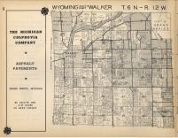 |
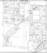
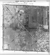
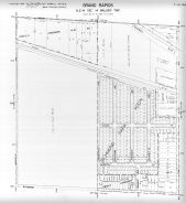
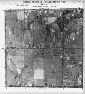
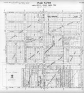
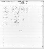
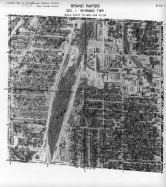
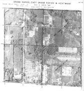
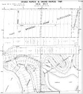
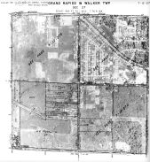
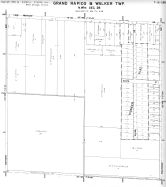
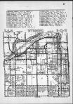
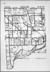
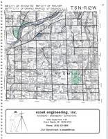
Wyoming, Walker, Grand Rapids T6N-R12W |
Kent County 1955 |
Rockford Map Publishers, Inc. |
1955 |
 |
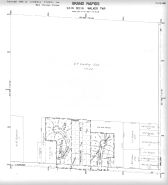
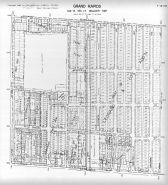
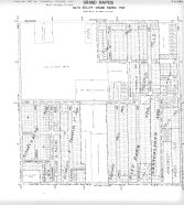
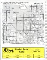
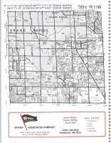
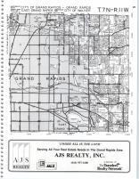
Paris, South Kent, Wyoming, Grand Rapids T6N-R11W |
Kent County 1955 |
Rockford Map Publishers, Inc. |
1955 |
 |
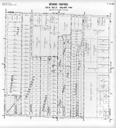
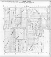
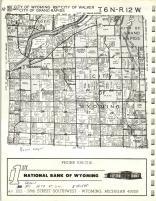
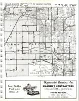
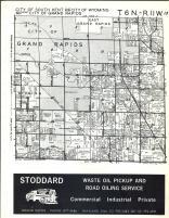
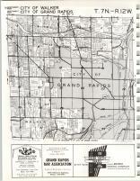
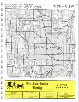
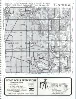
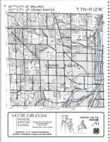
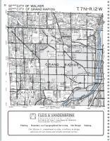
Walker, Grand Rapids T7N-R12W |
Kent County 1955 |
Rockford Map Publishers, Inc. |
1955 |
 |
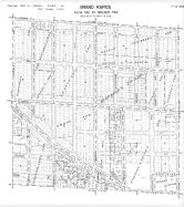
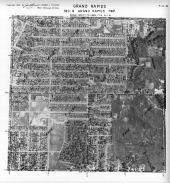
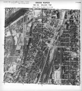
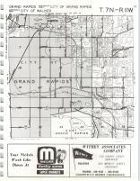
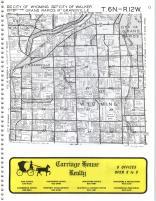
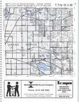
Grand Rapids, Walker T7N-R11E |
Kent County 1955 |
Rockford Map Publishers, Inc. |
1955 |
 |
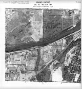
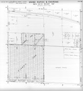
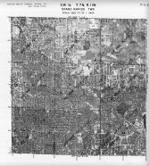
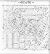
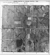
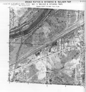
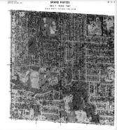
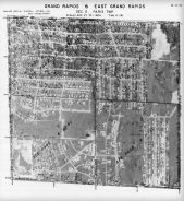
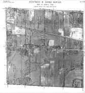
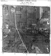
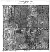
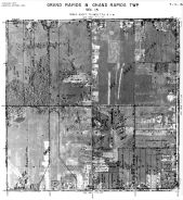
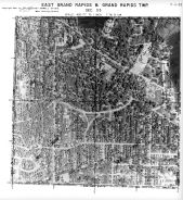
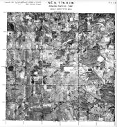
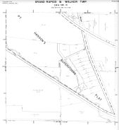
Page 7 - 12 - 35B - Walker Township, Grand Rapids, Sec. 35 |
Kent County 1960 Vol 1 Grand Rapids |
Sidwell Studio |
1960 |
 |
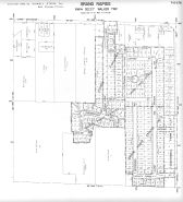
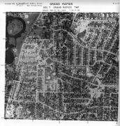
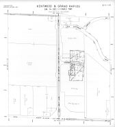
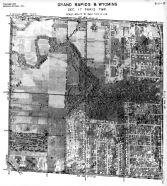
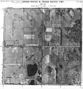
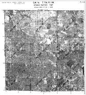
Page 7 - 12 - 35 - Walker Township, Grand Rapids, Sec. 35 - Aerial Index Map |
Kent County 1960 Vol 1 Grand Rapids |
Sidwell Studio |
1960 |
 |
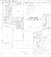
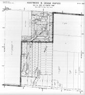
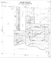
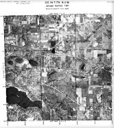
Page 7 - 12 - 34 - Grand Rapids and Walker Township, Sec. 34 - Aerial Map |
Kent County 1960 Vol 1 Grand Rapids |
Sidwell Studio |
1960 |
 |
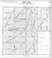
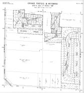
Page 7 - 12 - 28B - Walker Township, Grand Rapids and Environs, Sec. 28 |
Kent County 1960 Vol 1 Grand Rapids |
Sidwell Studio |
1960 |
 |
Page 7 - 12 - 28 - Grand Rapids and Walker Township, Sec. 28 |
Kent County 1960 Vol 1 Grand Rapids |
Sidwell Studio |
1960 |
 |
Page 7 - 12 - 27D - Walker Township, Grand Rapids, Grand Rapids and Environs, Sec. 27 |
Kent County 1960 Vol 1 Grand Rapids |
Sidwell Studio |
1960 |
 |
Page 7 - 12 - 27B - Walker Township, Grand Rapids, Sec. 27 |
Kent County 1960 Vol 1 Grand Rapids |
Sidwell Studio |
1960 |
 |
Page 7 - 12 - 27A - Walker Township, Grand Rapids, Sec. 27 |
Kent County 1960 Vol 1 Grand Rapids |
Sidwell Studio |
1960 |
 |
Page 7 - 12 - 27 - Walker Township, Grand Rapids, Sec. 27 - Aerial Index Map |
Kent County 1960 Vol 1 Grand Rapids |
Sidwell Studio |
1960 |
 |
Page 7 - 12 - 26D - Walker Township, Grand Rapids, Sec. 26 |
Kent County 1960 Vol 1 Grand Rapids |
Sidwell Studio |
1960 |
 |
Page 7 - 12 - 26C - Walker Township, Grand Rapids, Sec. 26 |
Kent County 1960 Vol 1 Grand Rapids |
Sidwell Studio |
1960 |
 |
Page 7 - 12 - 26B - Walker Township, Grand Rapids, Sec. 26 |
Kent County 1960 Vol 1 Grand Rapids |
Sidwell Studio |
1960 |
 |
Page 7 - 12 - 26A - Walker Township, Grand Rapids, Sec. 26 |
Kent County 1960 Vol 1 Grand Rapids |
Sidwell Studio |
1960 |
 |
Page 7 - 12 - 26 - Walker Township, Grand Rapids, Sec. 26 - Aerial Index Map |
Kent County 1960 Vol 1 Grand Rapids |
Sidwell Studio |
1960 |
 |
Page 7 - 12 - 25D - Walker Township, Grand Rapids, Sec. 25 |
Kent County 1960 Vol 1 Grand Rapids |
Sidwell Studio |
1960 |
 |
Page 7 - 12 - 25C - Walker Township, Grand Rapids, Sec. 25 |
Kent County 1960 Vol 1 Grand Rapids |
Sidwell Studio |
1960 |
 |
Page 7 - 12 - 25B - Walker Township, Grand Rapids, Sec. 25 |
Kent County 1960 Vol 1 Grand Rapids |
Sidwell Studio |
1960 |
 |
Page 7 - 12 - 25A - Walker Township, Grand Rapids, Sec. 25 |
Kent County 1960 Vol 1 Grand Rapids |
Sidwell Studio |
1960 |
 |
Page 7 - 12 - 25 - Walker Township, Grand Rapids, Sec. 25 - Aerial Index Map |
Kent County 1960 Vol 1 Grand Rapids |
Sidwell Studio |
1960 |
 |
Page 7 - 12 - 24C - Walker Township, Grand Rapids, Sec. 24 |
Kent County 1960 Vol 1 Grand Rapids |
Sidwell Studio |
1960 |
 |
Page 7 - 12 - 24D - Walker Township, Grand Rapids, Sec. 24 |
Kent County 1960 Vol 1 Grand Rapids |
Sidwell Studio |
1960 |
 |
Page 7 - 12 - 24B - Walker Township, Grand Rapids, Sec. 24 |
Kent County 1960 Vol 1 Grand Rapids |
Sidwell Studio |
1960 |
 |
Page 7 - 12 - 24A - Walker Township, Grand Rapids, Sec. 24 |
Kent County 1960 Vol 1 Grand Rapids |
Sidwell Studio |
1960 |
 |
Page 7 - 12 - 24 - Walker Township, Grand Rapids, Sec. 24 - Aerial Index Map |
Kent County 1960 Vol 1 Grand Rapids |
Sidwell Studio |
1960 |
 |
Page 7 - 12 - 23D - Walker Township, Grand Rapids, Sec. 23 |
Kent County 1960 Vol 1 Grand Rapids |
Sidwell Studio |
1960 |
 |
Page 7 - 12 - 23C - Walker Township, Grand Rapids, Sec. 23 |
Kent County 1960 Vol 1 Grand Rapids |
Sidwell Studio |
1960 |
 |
Page 7 - 12 - 23B - Walker Township, Grand Rapids, Sec. 23 |
Kent County 1960 Vol 1 Grand Rapids |
Sidwell Studio |
1960 |
 |
Page 7 - 12 - 23A - Walker Township, Grand Rapids, Sec. 23 |
Kent County 1960 Vol 1 Grand Rapids |
Sidwell Studio |
1960 |
 |
Page 7 - 12 - 22D - Walker Township, Grand Rapids, Sec. 22 |
Kent County 1960 Vol 1 Grand Rapids |
Sidwell Studio |
1960 |
 |
Page 7 - 12 - 22C - Walker Township, Grand Rapids, Sec. 22 |
Kent County 1960 Vol 1 Grand Rapids |
Sidwell Studio |
1960 |
 |
Page 7 - 12 - 22B - Walker Township, Grand Rapids, Sec. 22 |
Kent County 1960 Vol 1 Grand Rapids |
Sidwell Studio |
1960 |
 |
Page 7 - 12 - 22A - Walker Township, Grand Rapids, Sec. 22 |
Kent County 1960 Vol 1 Grand Rapids |
Sidwell Studio |
1960 |
 |
Page 7 - 12 - 22 - Walker Township, Grand Rapids, Sec. 22 - Aerial Index Map |
Kent County 1960 Vol 1 Grand Rapids |
Sidwell Studio |
1960 |
 |
Page 7 - 12 - 21A - Walker Township, Grand Rapids, Sec. 21 |
Kent County 1960 Vol 1 Grand Rapids |
Sidwell Studio |
1960 |
 |
Page 7 - 12 - 20D - Walker Township, Grand Rapids and Environs, Sec. 20 |
Kent County 1960 Vol 1 Grand Rapids |
Sidwell Studio |
1960 |
 |
Page 7 - 12 - 20 - Grand Rapids and Walker Township, Sec. 20 - Aerial Index Map |
Kent County 1960 Vol 1 Grand Rapids |
Sidwell Studio |
1960 |
 |
Page 7 - 12 - 1D - Walker and Grand Rapids Townships, Grand Rapids and Environs, Sec. 1 |
Kent County 1960 Vol 1 Grand Rapids |
Sidwell Studio |
1960 |
 |
Page 7 - 12 - 17D - Walker Township, Grand Rapids and Environs, Sec. 17 |
Kent County 1960 Vol 1 Grand Rapids |
Sidwell Studio |
1960 |
 |
Page 7 - 12 - 16D - Walker Township, Grand Rapids, Sec. 16 |
Kent County 1960 Vol 1 Grand Rapids |
Sidwell Studio |
1960 |
 |
Page 7 - 12 - 17 - Grand Rapids and Walker Township, Sec. 17 - Aerial Index Map |
Kent County 1960 Vol 1 Grand Rapids |
Sidwell Studio |
1960 |
 |
Page 7 - 12 - 16C - Walker Township, Grand Rapids, Sec. 16 |
Kent County 1960 Vol 1 Grand Rapids |
Sidwell Studio |
1960 |
 |
Page 7 - 12 - 16B - Walker Township, Grand Rapids and Environs, Sec. 16 |
Kent County 1960 Vol 1 Grand Rapids |
Sidwell Studio |
1960 |
 |
Page 7 - 12 - 16 - Grand Rapids and Walker Township, Sec. 16 - Aerial Index Map |
Kent County 1960 Vol 1 Grand Rapids |
Sidwell Studio |
1960 |
 |
Page 7 - 12 - 15D - Walker Township, Grand Rapids, Sec. 15 |
Kent County 1960 Vol 1 Grand Rapids |
Sidwell Studio |
1960 |
 |
Page 7 - 12 - 15C - Walker Township, Grand Rapids, Sec. 15 |
Kent County 1960 Vol 1 Grand Rapids |
Sidwell Studio |
1960 |
 |
Page 7 - 12 - 15B - Walker Township, Grand Rapids, Sec. 15 |
Kent County 1960 Vol 1 Grand Rapids |
Sidwell Studio |
1960 |
 |
Page 7 - 12 - 15 - Grand Rapids and Walker Township, Sec. 15 - Aerial Index Map |
Kent County 1960 Vol 1 Grand Rapids |
Sidwell Studio |
1960 |
 |
Page 7 - 12 - 14D - Walker Township, Grand Rapids, Sec. 14 |
Kent County 1960 Vol 1 Grand Rapids |
Sidwell Studio |
1960 |
 |
Page 7 - 12 - 14C - Walker Township, Grand Rapids, Sec. 14 |
Kent County 1960 Vol 1 Grand Rapids |
Sidwell Studio |
1960 |
 |
Page 7 - 12 - 14B - Walker Township, Grand Rapids and Environs, Sec. 14 |
Kent County 1960 Vol 1 Grand Rapids |
Sidwell Studio |
1960 |
 |
Page 7 - 12 - 14A - Walker Township, Grand Rapids, Sec. 14 |
Kent County 1960 Vol 1 Grand Rapids |
Sidwell Studio |
1960 |
 |
Page 7 - 12 - 14 - Grand Rapids and Walker Township, Sec. 14 - Aerial Index Map |
Kent County 1960 Vol 1 Grand Rapids |
Sidwell Studio |
1960 |
 |
Page 7 - 12 - 13D - Walker Township, Grand Rapids, Sec. 13 |
Kent County 1960 Vol 1 Grand Rapids |
Sidwell Studio |
1960 |
 |
Page 7 - 12 - 13C - Walker Township, Grand Rapids, Sec. 13 |
Kent County 1960 Vol 1 Grand Rapids |
Sidwell Studio |
1960 |
 |
Page 7 - 12 - 13B - Walker Township, Grand Rapids, Sec. 13 |
Kent County 1960 Vol 1 Grand Rapids |
Sidwell Studio |
1960 |
 |
Page 7 - 12 - 13A - Walker Township, Grand Rapids, Sec. 13 |
Kent County 1960 Vol 1 Grand Rapids |
Sidwell Studio |
1960 |
 |
Page 7 - 12 - 13 - Walker Township, Grand Rapids, Sec. 13 - Aerial Index Map |
Kent County 1960 Vol 1 Grand Rapids |
Sidwell Studio |
1960 |
 |
Page 7 - 12 - 12 - Grand Rapids and Walker Township, Sec. 12 - Aerial Index Map |
Kent County 1960 Vol 1 Grand Rapids |
Sidwell Studio |
1960 |
 |
Page 7 - 12 - 10C - Grand Rapids and Walker Township, Sec. 10 |
Kent County 1960 Vol 1 Grand Rapids |
Sidwell Studio |
1960 |
 |
Page 7 - 12 - 10 - Grand Rapids and Walker Township, Sec. 10 - Aerial Index Map |
Kent County 1960 Vol 1 Grand Rapids |
Sidwell Studio |
1960 |
 |
Page 7 - 12 - 1 - Grand Rapids and Walker Grand Rapids Township - Aerial Index Map |
Kent County 1960 Vol 1 Grand Rapids |
Sidwell Studio |
1960 |
 |
Page 7 - 11 - D - Grand Rapids Township - Aerial Index Map |
Kent County 1960 Vol 1 Grand Rapids |
Sidwell Studio |
1960 |
 |
Page 7 - 11 - C - Grand Rapids Township - Aerial Index Map |
Kent County 1960 Vol 1 Grand Rapids |
Sidwell Studio |
1960 |
 |
Page 7 - 11 - B - Walker and Grand Rapids Township - Aerial Index Map |
Kent County 1960 Vol 1 Grand Rapids |
Sidwell Studio |
1960 |
 |
Page 7 - 11 - A - Grand Rapids Township - Aerial Index Map |
Kent County 1960 Vol 1 Grand Rapids |
Sidwell Studio |
1960 |
 |
Page 7 - 11 - 9C - Grand Rapids Township - Grand Rapids, Sec. 9 |
Kent County 1960 Vol 1 Grand Rapids |
Sidwell Studio |
1960 |
 |
Page 7 - 11 - 9B - Grand Rapids and Grand Rapids Township, Sec. 9 |
Kent County 1960 Vol 1 Grand Rapids |
Sidwell Studio |
1960 |
 |
Page 7 - 11 - 8D - Grand Rapids Township, Grand Rapids, Sec. 8 |
Kent County 1960 Vol 1 Grand Rapids |
Sidwell Studio |
1960 |
 |
Page 7 - 11 - 9 - Grand Rapids and Grand Rapids Township, Sec. 9 - Aeriel Index Map |
Kent County 1960 Vol 1 Grand Rapids |
Sidwell Studio |
1960 |
 |
Page 7 - 11 - 8B - Grand Rapids Township, Grand Rapids, Sec. 8 |
Kent County 1960 Vol 1 Grand Rapids |
Sidwell Studio |
1960 |
 |
Page 7 - 11 - 8A - Grand Rapids Township, Grand Rapids, Sec. 8 |
Kent County 1960 Vol 1 Grand Rapids |
Sidwell Studio |
1960 |
 |
Page 7 - 11 - 8 - Grand Rapids Township, Grand Rapids, Sec. 8 - Aerial Index Map |
Kent County 1960 Vol 1 Grand Rapids |
Sidwell Studio |
1960 |
 |
Page 7 - 11 - 7D - Grand Rapids Township, Grand Rapids, Sec. 7 |
Kent County 1960 Vol 1 Grand Rapids |
Sidwell Studio |
1960 |
 |
Page 7 - 11 - 7C - Grand Rapids Township, Grand Rapids, Sec. 7 |
Kent County 1960 Vol 1 Grand Rapids |
Sidwell Studio |
1960 |
 |
Page 7 - 11 - 7B - Grand Rapids Township, Grand Rapids, Sec. 7 |
Kent County 1960 Vol 1 Grand Rapids |
Sidwell Studio |
1960 |
 |
Page 7 - 11 - 7A - Grand Rapids Township, Grand Rapids, Sec. 7 |
Kent County 1960 Vol 1 Grand Rapids |
Sidwell Studio |
1960 |
 |
Page 7 - 11 - 7 - Grand Rapids Township, Grand Rapids, Sec. 7 - Aerial Index Map |
Kent County 1960 Vol 1 Grand Rapids |
Sidwell Studio |
1960 |
 |
Page 7 - 11 - 6D - Grand Rapids Township, Grand Rapids, Sec. 6 |
Kent County 1960 Vol 1 Grand Rapids |
Sidwell Studio |
1960 |
 |
Page 7 - 11 - 6A - Grand Rapids Township, Grand Rapids, Sec. 6 |
Kent County 1960 Vol 1 Grand Rapids |
Sidwell Studio |
1960 |
 |
Page 7 - 11 - 6 - Grand Rapids and Walker Township, Walker, and Grand Rapids Twps., Sec. 6 - Aerial Index Map |
Kent County 1960 Vol 1 Grand Rapids |
Sidwell Studio |
1960 |
 |
Page 7 - 11 - 5D - Grand Rapids Township, Sec. 5 |
Kent County 1960 Vol 1 Grand Rapids |
Sidwell Studio |
1960 |
 |
Page 7 - 11 - 5C - Grand Rapids Township, Grand Rapids, Sec. 5 |
Kent County 1960 Vol 1 Grand Rapids |
Sidwell Studio |
1960 |
 |
Page 7 - 11 - 5B - Grand Rapids Township, Grand Rapids, Sec |
Kent County 1960 Vol 1 Grand Rapids |
Sidwell Studio |
1960 |
 |
Page 7 - 11 - 5A - Grand Rapids and Grand Rapids Township, Sec.5 |
Kent County 1960 Vol 1 Grand Rapids |
Sidwell Studio |
1960 |
 |
Page 7 - 11 - 5 - Grand Rapids and Grand Rapids Township, Sec.5 - Aerial Index Map |
Kent County 1960 Vol 1 Grand Rapids |
Sidwell Studio |
1960 |
 |
Page 7 - 11 - 4C - Grand Rapids Township, Grand Rapids and Environs, Sec. 4 |
Kent County 1960 Vol 1 Grand Rapids |
Sidwell Studio |
1960 |
 |
Page 7 - 11 - 4B - Grand Rapids Township, Grand Rapids and Environs, Sec. 4 |
Kent County 1960 Vol 1 Grand Rapids |
Sidwell Studio |
1960 |
 |
Page 7 - 11 - 4 - Grand Rapids and Grand Rapids Township, Sec. 4 - Aerial Index Map |
Kent County 1960 Vol 1 Grand Rapids |
Sidwell Studio |
1960 |
 |
Page 7 - 11 - 32D - Grand Rapids Township, Grand Rapids, Sec. 32 |
Kent County 1960 Vol 1 Grand Rapids |
Sidwell Studio |
1960 |
 |
Page 7 - 11 - 32C - Grand Rapids Township, Grand Rapids, Sec. 32 |
Kent County 1960 Vol 1 Grand Rapids |
Sidwell Studio |
1960 |
 |
Page 7 - 11 - 32B - Grand Rapids Township, Grand Rapids, Sec. 32 |
Kent County 1960 Vol 1 Grand Rapids |
Sidwell Studio |
1960 |
 |
Page 7 - 11 - 32A - Grand Rapids Township, Grand Rapids, Sec. 32 |
Kent County 1960 Vol 1 Grand Rapids |
Sidwell Studio |
1960 |
 |
Page 7 - 11 - 32 - Grand Rapids Township, Grand Rapids, Sec. 32 - Aerial Index Map |
Kent County 1960 Vol 1 Grand Rapids |
Sidwell Studio |
1960 |
 |
Page 7 - 11 - 31D - Grand Rapids Township, Grand Rapids, Sec. 31 |
Kent County 1960 Vol 1 Grand Rapids |
Sidwell Studio |
1960 |
 |
Page 7 - 11 - 31C - Grand Rapids Township, Grand Rapids, Sec. 31 |
Kent County 1960 Vol 1 Grand Rapids |
Sidwell Studio |
1960 |
 |
Page 7 - 11 - 31B - Grand Rapids Township, Grand Rapids, Sec. 31 |
Kent County 1960 Vol 1 Grand Rapids |
Sidwell Studio |
1960 |
 |
Page 7 - 11 - 31A - Grand Rapids Township, Grand Rapids, Sec. 31 |
Kent County 1960 Vol 1 Grand Rapids |
Sidwell Studio |
1960 |
 |
Page 7 - 11 - 31 - Grand Rapids Township, Grand Rapids, Sec. 31 - Aerial Index Map |
Kent County 1960 Vol 1 Grand Rapids |
Sidwell Studio |
1960 |
 |
Page 7 - 11 - 30D - Grand Rapids Township, Grand Rapids, Sec. 30 |
Kent County 1960 Vol 1 Grand Rapids |
Sidwell Studio |
1960 |
 |
Page 7 - 11 - 30C - Grand Rapids Township, Grand Rapids, Sec. 30 |
Kent County 1960 Vol 1 Grand Rapids |
Sidwell Studio |
1960 |
 |
Page 7 - 11 - 30B - Grand Rapids Township, Grand Rapids, Sec. 30 |
Kent County 1960 Vol 1 Grand Rapids |
Sidwell Studio |
1960 |
 |
Page 7 - 11 - 30A - Grand Rapids Township, Grand Rapids, Sec. 30 |
Kent County 1960 Vol 1 Grand Rapids |
Sidwell Studio |
1960 |
 |
Page 7 - 11 - 29D - Grand Rapids Township, Grand Rapids, Sec. 29 |
Kent County 1960 Vol 1 Grand Rapids |
Sidwell Studio |
1960 |
 |
Page 7 - 11 - 30 - Grand Rapids Township, Grand Rapids, Sec. 30 - Aerial Index Map |
Kent County 1960 Vol 1 Grand Rapids |
Sidwell Studio |
1960 |
 |
Page 7 - 11 - 29C - Grand Rapids Township, Grand Rapids, Sec. 29 |
Kent County 1960 Vol 1 Grand Rapids |
Sidwell Studio |
1960 |
 |
Page 7 - 11 - 29B - Grand Rapids Township, Grand Rapids, Sec. 29 |
Kent County 1960 Vol 1 Grand Rapids |
Sidwell Studio |
1960 |
 |
Page 7 - 11 - 29A - Grand Rapids Township, Grand Rapids, Sec. 29 |
Kent County 1960 Vol 1 Grand Rapids |
Sidwell Studio |
1960 |
 |
Page 7 - 11 - 29 - Grand Rapids Township, Grand Rapids, Sec. 29 - Aerial Index Map |
Kent County 1960 Vol 1 Grand Rapids |
Sidwell Studio |
1960 |
 |
Page 7 - 11 - 28D - Grand Rapids Township, Grand Rapids and East Grand Rapids, Sec. 28 |
Kent County 1960 Vol 1 Grand Rapids |
Sidwell Studio |
1960 |
 |
Page 7 - 11 - 28C - Grand Rapids Township, Grand Rapids and East Grand Rapids, Sec. 28 |
Kent County 1960 Vol 1 Grand Rapids |
Sidwell Studio |
1960 |
 |
Page 7 - 11 - 28A - Grand Rapids Township, Grand Rapids, Sec. 28 |
Kent County 1960 Vol 1 Grand Rapids |
Sidwell Studio |
1960 |
 |
Page 7 - 11 - 28B - Grand Rapids Township, Grand Rapids, Sec. 28 |
Kent County 1960 Vol 1 Grand Rapids |
Sidwell Studio |
1960 |
 |
Page 7 - 11 - 28 - Grand Rapids Township, Grand Rapids and East Grand Rapids, Sec. 28 - Aerial Index Map |
Kent County 1960 Vol 1 Grand Rapids |
Sidwell Studio |
1960 |
 |
Page 7 - 11 - 27D - Grand Rapids Township, Grand Rapids and East Grand Rapids, Sec. 27 |
Kent County 1960 Vol 1 Grand Rapids |
Sidwell Studio |
1960 |
 |
Page 7 - 11 - 27C - Grand Rapids Township, Grand Rapids and East Grand Rapids, Sec. 27 |
Kent County 1960 Vol 1 Grand Rapids |
Sidwell Studio |
1960 |
 |
Page 7 - 11 - 27B - Grand Rapids Township, Grand Rapids, Sec. 27 |
Kent County 1960 Vol 1 Grand Rapids |
Sidwell Studio |
1960 |
 |
Page 7 - 11 - 27A - Grand Rapids Township, Grand Rapids, Sec. 27 |
Kent County 1960 Vol 1 Grand Rapids |
Sidwell Studio |
1960 |
 |
Page 7 - 11 - 27 - Grand Rapids Township, Grand Rapids and East Grand Rapids, Sec. 27 - Aerial Index Map |
Kent County 1960 Vol 1 Grand Rapids |
Sidwell Studio |
1960 |
 |
Page 7 - 11 - 23C - Grand Rapids Township, Grand Rapids and Envrons, Sec. 23 |
Kent County 1960 Vol 1 Grand Rapids |
Sidwell Studio |
1960 |
 |
Page 7 - 11 - 23 - Grand Rapids and Grand Rapids Township, Sec. 23 - Aerial Index Map |
Kent County 1960 Vol 1 Grand Rapids |
Sidwell Studio |
1960 |
 |
Page 7 - 11 - 22B - Grand Rapids Township, Grand Rapids - Sec. 22 |
Kent County 1960 Vol 1 Grand Rapids |
Sidwell Studio |
1960 |
 |
Page 7 - 11 - 22 - Grand Rapids Township, Grand Rapids - Sec. 22 - Aerial Index Map |
Kent County 1960 Vol 1 Grand Rapids |
Sidwell Studio |
1960 |
 |
Page 7 - 11 - 21D - Grand Rapids Township, Grand Rapids - Sec. 21 |
Kent County 1960 Vol 1 Grand Rapids |
Sidwell Studio |
1960 |
 |
Page 7 - 11 - 21B - Grand Rapids Township, Grand Rapids - Sec. 21 |
Kent County 1960 Vol 1 Grand Rapids |
Sidwell Studio |
1960 |
 |
Page 7 - 11 - 21A - Grand Rapids Township, Grand Rapids - Sec. 21 |
Kent County 1960 Vol 1 Grand Rapids |
Sidwell Studio |
1960 |
 |
Page 7 - 11 - 21 - Grand Rapids Township, Grand Rapids - Sec. 21- Aerial Index Map |
Kent County 1960 Vol 1 Grand Rapids |
Sidwell Studio |
1960 |
 |
Page 7 - 11 - 20D - Grand Rapids Township, Grand Rapids - Sec. 20 |
Kent County 1960 Vol 1 Grand Rapids |
Sidwell Studio |
1960 |
 |
Page 7 - 11 - 20C - Grand Rapids Township, Grand Rapids - Sec. 20 |
Kent County 1960 Vol 1 Grand Rapids |
Sidwell Studio |
1960 |
 |
Page 7 - 11 - 20B - Grand Rapids Township, Sec. 20 |
Kent County 1960 Vol 1 Grand Rapids |
Sidwell Studio |
1960 |
 |
Page 7 - 11 - 20A - Grand Rapids Township, Sec. 20 |
Kent County 1960 Vol 1 Grand Rapids |
Sidwell Studio |
1960 |
 |
Page 7 - 11 - 20 - Grand Rapids Township - Grand Rapids, Sec. 20 - Aerial Index Map |
Kent County 1960 Vol 1 Grand Rapids |
Sidwell Studio |
1960 |
 |
Page 7 - 11 - 19D - Grand Rapids Township - Grand Rapids, Sec. 19 |
Kent County 1960 Vol 1 Grand Rapids |
Sidwell Studio |
1960 |
 |
Page 7 - 11 - 19C - Grand Rapids Township - Grand Rapids, Sec. 19 |
Kent County 1960 Vol 1 Grand Rapids |
Sidwell Studio |
1960 |
 |
Page 7 - 11 - 19B - Grand Rapids Township - Grand Rapids, Sec. 19 |
Kent County 1960 Vol 1 Grand Rapids |
Sidwell Studio |
1960 |
 |
Page 7 - 11 - 19A - Grand Rapids Township - Grand Rapids, Sec. 19 |
Kent County 1960 Vol 1 Grand Rapids |
Sidwell Studio |
1960 |
 |
Page 7 - 11 - 19 - Grand Rapids Township - Grand Rapids, Sec. 19 - Aerial Index Map |
Kent County 1960 Vol 1 Grand Rapids |
Sidwell Studio |
1960 |
 |
Page 7 - 11 - 18D - Grand Rapids Township - Grand Rapids, Sec. 18 |
Kent County 1960 Vol 1 Grand Rapids |
Sidwell Studio |
1960 |
 |
Page 7 - 11 - 18C - Grand Rapids Township - Grand Rapids, Sec. 18 |
Kent County 1960 Vol 1 Grand Rapids |
Sidwell Studio |
1960 |
 |
Page 7 - 11 - 18B - Grand Rapids Township - Grand Rapids, Sec. 18 |
Kent County 1960 Vol 1 Grand Rapids |
Sidwell Studio |
1960 |
 |
Page 7 - 11 - 18A - Grand Rapids Township - Grand Rapids, Sec. 18 |
Kent County 1960 Vol 1 Grand Rapids |
Sidwell Studio |
1960 |
 |
Page 7 - 11 - 18 - Grand Rapids Township - Grand Rapids, Sec. 18 - Aerial Index Map |
Kent County 1960 Vol 1 Grand Rapids |
Sidwell Studio |
1960 |
 |
Page 7 - 11 - 17D - Grand Rapids Township - Grand Rapids, Sec. 17 |
Kent County 1960 Vol 1 Grand Rapids |
Sidwell Studio |
1960 |
 |
Page 7 - 11 - 17B - Grand Rapids Township - Grand Rapids, Sec. 17 |
Kent County 1960 Vol 1 Grand Rapids |
Sidwell Studio |
1960 |
 |
Page 7 - 11 - 17C - Grand Rapids Township - Grand Rapids, Sec. 17 |
Kent County 1960 Vol 1 Grand Rapids |
Sidwell Studio |
1960 |
 |
Page 7 - 11 - 17A - Grand Rapids Township - Grand Rapids, Sec. 17 |
Kent County 1960 Vol 1 Grand Rapids |
Sidwell Studio |
1960 |
 |
Page 7 - 11 - 17 - Grand Rapids Township - Grand Rapids, Sec. 17 - Aerial Index Map |
Kent County 1960 Vol 1 Grand Rapids |
Sidwell Studio |
1960 |
 |
Page 7 - 11 - 16D - Grand Rapids Township - Grand Rapids, Sec. 16 |
Kent County 1960 Vol 1 Grand Rapids |
Sidwell Studio |
1960 |
 |
Page 7 - 11 - 16B - Grand Rapids Township, Sec. 16 |
Kent County 1960 Vol 1 Grand Rapids |
Sidwell Studio |
1960 |
 |
Page 7 - 11 - 16C - Grand Rapids Township, Sec. 16 |
Kent County 1960 Vol 1 Grand Rapids |
Sidwell Studio |
1960 |
 |
Page 7 - 11 - 16A - Grand Rapids Township, Sec. 16 |
Kent County 1960 Vol 1 Grand Rapids |
Sidwell Studio |
1960 |
 |
Page 7 - 11 - 16 - Grand Rapids Township, Sec. 16 - Aerial Index Map |
Kent County 1960 Vol 1 Grand Rapids |
Sidwell Studio |
1960 |
 |
Page 7 - 11 - 15C - Grand Rapids Township, Sec. 15 |
Kent County 1960 Vol 1 Grand Rapids |
Sidwell Studio |
1960 |
 |
Page 7 - 11 - 15 - Grand Rapids and Grand Rapids Township, Sec. 15 - Aerial Index Map |
Kent County 1960 Vol 1 Grand Rapids |
Sidwell Studio |
1960 |
 |
Page 6 - 12 - 3 - Grand Rapids, Wyoming and Walker Townships Sec. 3 - Aerial Index Map |
Kent County 1960 Vol 1 Grand Rapids |
Sidwell Studio |
1960 |
 |
Page 6 - 12 - 2A - Wyoming Township, Grand Rapids and Wyoming. Sec. 2 |
Kent County 1960 Vol 1 Grand Rapids |
Sidwell Studio |
1960 |
 |
Page 6 - 12 - 2 - Wyoming Township, Grand Rapids and Wyoming. Sec. 2 - Aerial Index Map |
Kent County 1960 Vol 1 Grand Rapids |
Sidwell Studio |
1960 |
 |
Page 6 - 12 - 1D - Wyoming Township, Grand Rapids. Sec. 1 |
Kent County 1960 Vol 1 Grand Rapids |
Sidwell Studio |
1960 |
 |
Page 6 - 12 - 1C - Wyoming Township, Grand Rapids. Sec. 1 |
Kent County 1960 Vol 1 Grand Rapids |
Sidwell Studio |
1960 |
 |
Page 6 - 12 - 1A - Wyoming Township, Grand Rapids. Sec. 1 |
Kent County 1960 Vol 1 Grand Rapids |
Sidwell Studio |
1960 |
 |
Page 6 - 12 - 1B - Wyoming Township, Grand Rapids. Sec. 1 |
Kent County 1960 Vol 1 Grand Rapids |
Sidwell Studio |
1960 |
 |
Page 6 - 12 - 12B - Wyoming Township, Grand Rapids, Sec. 12 |
Kent County 1960 Vol 1 Grand Rapids |
Sidwell Studio |
1960 |
 |
Page 6 - 12 - 12A - Wyoming Township, Grand Rapids, Sec. 12 |
Kent County 1960 Vol 1 Grand Rapids |
Sidwell Studio |
1960 |
 |
Page 6 - 12 - 12 - Wyoming Township, Grand Rapids and Wyoming, Sec. 12 - Aerial Index Map |
Kent County 1960 Vol 1 Grand Rapids |
Sidwell Studio |
1960 |
 |
Page 6 - 12 - 1 - Wyoming Township, Grand Rapids. Sec. 1 - Aerial Index Map |
Kent County 1960 Vol 1 Grand Rapids |
Sidwell Studio |
1960 |
 |
Page 6 - 11 - 9B - Paris Township - Grand Rapids, Sec. 9 |
Kent County 1960 Vol 1 Grand Rapids |
Sidwell Studio |
1960 |
 |
Page 6 - 11 - 9D - Paris Township - Grand Rapids, Sec. 9 |
Kent County 1960 Vol 1 Grand Rapids |
Sidwell Studio |
1960 |
 |
Page 6 - 11 - 9A - Paris Township - Grand Rapids, Sec. 9 |
Kent County 1960 Vol 1 Grand Rapids |
Sidwell Studio |
1960 |
 |
Page 6 - 11 - 9 - Paris Township - Grand Rapids, Sec. 9 - Aerial Index Map |
Kent County 1960 Vol 1 Grand Rapids |
Sidwell Studio |
1960 |
 |
Page 6 - 11 - 8C - Paris Township - Grand Rapids, Sec. 8 |
Kent County 1960 Vol 1 Grand Rapids |
Sidwell Studio |
1960 |
 |
Page 6 - 11 - 8B - Paris Township - Grand Rapids, Sec. 8 |
Kent County 1960 Vol 1 Grand Rapids |
Sidwell Studio |
1960 |
 |
Page 6 - 11 - 8A - Paris Township - Grand Rapids, Sec. 8 |
Kent County 1960 Vol 1 Grand Rapids |
Sidwell Studio |
1960 |
 |
Page 6 - 11 - 8 - Paris Township - Grand Rapids, Sec. 8 - Aerial Index Map |
Kent County 1960 Vol 1 Grand Rapids |
Sidwell Studio |
1960 |
 |
Page 6 - 11 - 7DC - Paris Township - Grand Rapids, Sec. 7 |
Kent County 1960 Vol 1 Grand Rapids |
Sidwell Studio |
1960 |
 |
Page 6 - 11 - 7C - Paris Township - Grand Rapids, Sec. 7 |
Kent County 1960 Vol 1 Grand Rapids |
Sidwell Studio |
1960 |
 |
Page 6 - 11 - 7B - Paris Township - Grand Rapids, Sec. 7 |
Kent County 1960 Vol 1 Grand Rapids |
Sidwell Studio |
1960 |
 |
Page 6 - 11 - 7A - Paris Township - Grand Rapids, Sec. 7 |
Kent County 1960 Vol 1 Grand Rapids |
Sidwell Studio |
1960 |
 |
Page 6 - 11 - 7 - Paris Township - Grand Rapids, Sec. 7 - Aerial Index Map |
Kent County 1960 Vol 1 Grand Rapids |
Sidwell Studio |
1960 |
 |
Page 6 - 11 - 6D - Paris Township - Grand Rapids, Sec. 6 |
Kent County 1960 Vol 1 Grand Rapids |
Sidwell Studio |
1960 |
 |
Page 6 - 11 - 6C - Paris Township - Grand Rapids, Sec. 6 |
Kent County 1960 Vol 1 Grand Rapids |
Sidwell Studio |
1960 |
 |
Page 6 - 11 - 6B - Paris Township - Grand Rapids, Sec. 6 |
Kent County 1960 Vol 1 Grand Rapids |
Sidwell Studio |
1960 |
 |
Page 6 - 11 - 6A - Paris Township - Grand Rapids City, Sec. 6 |
Kent County 1960 Vol 1 Grand Rapids |
Sidwell Studio |
1960 |
 |
Page 6 - 11 - 6 - Paris Township - Grand Rapids, Sec. 6 |
Kent County 1960 Vol 1 Grand Rapids |
Sidwell Studio |
1960 |
 |
Page 6 - 11 - 5D - Paris Township - Grand Rapids, Sec. 5 |
Kent County 1960 Vol 1 Grand Rapids |
Sidwell Studio |
1960 |
 |
Page 6 - 11 - 5C - Paris Township - Grand Rapids City, Sec. 5 |
Kent County 1960 Vol 1 Grand Rapids |
Sidwell Studio |
1960 |
 |
Page 6 - 11 - 5B - Paris Township - Grand Rapids City, Sec. 5 |
Kent County 1960 Vol 1 Grand Rapids |
Sidwell Studio |
1960 |
 |
Page 6 - 11 - 5A - Paris Township - Grand Rapids, Sec. 5 |
Kent County 1960 Vol 1 Grand Rapids |
Sidwell Studio |
1960 |
 |
Page 6 - 11 - 5 - Paris Township - Grand Rapids, Sec. 5 - Aerial Index Map |
Kent County 1960 Vol 1 Grand Rapids |
Sidwell Studio |
1960 |
 |
Page 6 - 11 - 4D - Paris Township - Grand Rapids and East Grand Rapids, Sec. 4 |
Kent County 1960 Vol 1 Grand Rapids |
Sidwell Studio |
1960 |
 |
Page 6 - 11 - 4C - Paris Township - Grand Rapids, Sec. 4 |
Kent County 1960 Vol 1 Grand Rapids |
Sidwell Studio |
1960 |
 |
Page 6 - 11 - 4B - Paris Township - Grand Rapids, Sec. 4 |
Kent County 1960 Vol 1 Grand Rapids |
Sidwell Studio |
1960 |
 |
Page 6 - 11 - 4A - Paris Township - Grand Rapids and East Grand Rapids, Sec. 4 |
Kent County 1960 Vol 1 Grand Rapids |
Sidwell Studio |
1960 |
 |
Page 6 - 11 - 4 - Paris Township - Grand Rapids and East Grand Rapids, Sec. 4 - Aerial Index Township |
Kent County 1960 Vol 1 Grand Rapids |
Sidwell Studio |
1960 |
 |
Page 6 - 11 - 3D - Paris Township - Grand Rapids, Sec. 3 |
Kent County 1960 Vol 1 Grand Rapids |
Sidwell Studio |
1960 |
 |
Page 6 - 11 - 3C - Paris Township - Grand Rapids and East Grand Rapids, Sec. 3 |
Kent County 1960 Vol 1 Grand Rapids |
Sidwell Studio |
1960 |
 |
Page 6 - 11 - 3 - Paris Township - Grand Rapids and East Grand Rapids, Sec. 3 - Aerial Index Map |
Kent County 1960 Vol 1 Grand Rapids |
Sidwell Studio |
1960 |
 |
Page 6 - 11 - 2B - Paris Township - Grand Rapids, East Grand Rapids and Kentwood, Sec. 2 |
Kent County 1960 Vol 1 Grand Rapids |
Sidwell Studio |
1960 |
 |
Page 6 - 11 - 21C - Paris Township - Grand Rapids and Kentwood, Sec. 21 |
Kent County 1960 Vol 1 Grand Rapids |
Sidwell Studio |
1960 |
 |
Page 6 - 11 - 21B - Paris Township - Grand Rapids, Sec. 21 |
Kent County 1960 Vol 1 Grand Rapids |
Sidwell Studio |
1960 |
 |
Page 6 - 11 - 21 - Paris Township - Grand Rapids and Kentwood, Sec. 21 - Aerial Index Map |
Kent County 1960 Vol 1 Grand Rapids |
Sidwell Studio |
1960 |
 |
Page 6 - 11 - 20D - Paris Township - Grand Rapids Sec. 20 |
Kent County 1960 Vol 1 Grand Rapids |
Sidwell Studio |
1960 |
 |
Page 6 - 11 - 20A - Paris Township - Grand Rapids and Wyoming, Sec. 20 |
Kent County 1960 Vol 1 Grand Rapids |
Sidwell Studio |
1960 |
 |
Page 6 - 11 - 20 - Paris Township - Grand Rapids and Wyoming, Sec. 20 - Aerial Index Map |
Kent County 1960 Vol 1 Grand Rapids |
Sidwell Studio |
1960 |
 |
Page 6 - 11 - 2 - Paris Township - Grand Rapids, East Grand Rapids and Kentwood, Sec. 2 - Aerial Index Map |
Kent County 1960 Vol 1 Grand Rapids |
Sidwell Studio |
1960 |
 |
Page 6 - 11 - 18B - Paris Township - Grand Rapids and Wyoming, Sec. 18 |
Kent County 1960 Vol 1 Grand Rapids |
Sidwell Studio |
1960 |
 |
Page 6 - 11 - 18A - Paris Township - Grand Rapids and Wyoming, Sec. 18 |
Kent County 1960 Vol 1 Grand Rapids |
Sidwell Studio |
1960 |
 |
Page 6 - 11 - 18 - Paris Township - Grand Rapids and Wyoming, Sec. 18 - Aerial Index Map |
Kent County 1960 Vol 1 Grand Rapids |
Sidwell Studio |
1960 |
 |
Page 6 - 11 - 17D - Paris Township - Grand Rapids, Sec. 17 |
Kent County 1960 Vol 1 Grand Rapids |
Sidwell Studio |
1960 |
 |
Page 6 - 11 - 17C - Paris Township - Grand Rapids and Wyoming, Sec. 17 |
Kent County 1960 Vol 1 Grand Rapids |
Sidwell Studio |
1960 |
 |
Page 6 - 11 - 17B - Paris Township - Grand Rapids, Sec. 17 |
Kent County 1960 Vol 1 Grand Rapids |
Sidwell Studio |
1960 |
 |
Page 6 - 11 - 17A - Paris Township - Grand Rapids, Sec. 17 |
Kent County 1960 Vol 1 Grand Rapids |
Sidwell Studio |
1960 |
 |
Page 6 - 11 - 17 - Paris Township - Grand Rapids and Wyoming, Sec. 17 - Aerial Index Map |
Kent County 1960 Vol 1 Grand Rapids |
Sidwell Studio |
1960 |
 |
Page 6 - 11 - 16C - Paris Township - Grand Rapids, Sec. 16 |
Kent County 1960 Vol 1 Grand Rapids |
Sidwell Studio |
1960 |
 |
Page 6 - 11 - 16B - Paris Township - Grand Rapids, Sec. 16 |
Kent County 1960 Vol 1 Grand Rapids |
Sidwell Studio |
1960 |
 |
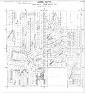
Page 6 - 11 - 16 - Paris Township - Kentwood and Grand Rapids, Sec. 16- Aerial Map |
Kent County 1960 Vol 1 Grand Rapids |
Sidwell Studio |
1960 |
 |
Page 6 - 11 - 15 - Paris Township - Kentwood and Grand Rapids, Sec. 15- Aerial Map |
Kent County 1960 Vol 1 Grand Rapids |
Sidwell Studio |
1960 |
 |
Page 6 - 11 - 14 - Paris Township - Kentwood and Grand Rapids, Sec. 14 - Aerial Index Map |
Kent County 1960 Vol 1 Grand Rapids |
Sidwell Studio |
1960 |
 |
Page 6 - 11 - 11C - Paris Township - Kentwood and Grand Rapids, Sec. 11 |
Kent County 1960 Vol 1 Grand Rapids |
Sidwell Studio |
1960 |
 |
Page 6 - 11 - 11A - Paris Township - Grand Rapids, Sec. 18 |
Kent County 1960 Vol 1 Grand Rapids |
Sidwell Studio |
1960 |
 |
Page 6 - 11 - 11 - Paris Township - Kentwood and Grand Rapids, Sec. 11 - Aerial Index Map |
Kent County 1960 Vol 1 Grand Rapids |
Sidwell Studio |
1960 |
 |
Page 6 - 11 - 10D - Paris Township - Kentwood and Grand Rapids, Sec. 10 |
Kent County 1960 Vol 1 Grand Rapids |
Sidwell Studio |
1960 |
 |
Page 6 - 11 - 10C - Paris Township - Grand Rapids, Sec. 10 |
Kent County 1960 Vol 1 Grand Rapids |
Sidwell Studio |
1960 |
 |
Page 6 - 11 - 10B - Paris Township - Grand Rapids, Sec. 10 |
Kent County 1960 Vol 1 Grand Rapids |
Sidwell Studio |
1960 |
 |
Page 6 - 11 - 10A - Paris Township - Grand Rapids, Sec. 10 |
Kent County 1960 Vol 1 Grand Rapids |
Sidwell Studio |
1960 |
 |
Page 6 - 11 - 10 - Paris Township - Kentwood and Grand Rapids, Sec. 10 - Aerial Indexf Map |
Kent County 1960 Vol 1 Grand Rapids |
Sidwell Studio |
1960 |
 |
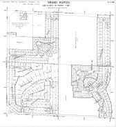
Index Street Map - East Grand Rapids, Wyoming, Grandville and Environs 2 |
Kent County 1960 Vol 1 Grand Rapids |
Sidwell Studio |
1960 |
 |
Index Street Map - East Grand Rapids, Wyoming, Grandville and Environs 1 |
Kent County 1960 Vol 1 Grand Rapids |
Sidwell Studio |
1960 |
 |
Index - Streets - East Grand Rapids, Wyoming, Grandville and Environs 3 |
Kent County 1960 Vol 1 Grand Rapids |
Sidwell Studio |
1960 |
 |
Index - Streets - East Grand Rapids, Wyoming, Grandville and Environs 2 |
Kent County 1960 Vol 1 Grand Rapids |
Sidwell Studio |
1960 |
 |
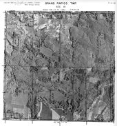
Page 7 - 12 - 23 - Walker Township, Grand Rapids, Sec. 23 - Aerial Index Map |
Kent County 1960 Vol 1 Grand Rapids |
Sidwell Studio |
1960 |
 |
Page 7 - 11 - 8C - Grand Rapids Township, Grand Rapids, Sec. 8 |
Kent County 1960 Vol 1 Grand Rapids |
Sidwell Studio |
1960 |
 |
Index - Streets - East Grand Rapids, Wyoming, Grandville and Environs 1 |
Kent County 1960 Vol 1 Grand Rapids |
Sidwell Studio |
1960 |
 |
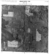
Page 7 - 12 - 35D - Walker Township, Grand Rapids, Sec. 35 |
Kent County 1960 Vol 1 Grand Rapids |
Sidwell Studio |
1960 |
 |
Page 7 - 12 - 36 - Walker Township, Grand Rapids, Sec. 36 - Aerial Index Map |
Kent County 1960 Vol 1 Grand Rapids |
Sidwell Studio |
1960 |
 |
Page 7 - 12 - 36A - Walker Township, Grand Rapids, Sec. 36 |
Kent County 1960 Vol 1 Grand Rapids |
Sidwell Studio |
1960 |
 |
Page 7 - 12 - 36B - Walker Township, Grand Rapids, Sec. 36 |
Kent County 1960 Vol 1 Grand Rapids |
Sidwell Studio |
1960 |
 |
Page 7 - 12 - 36C - Walker Township, Grand Rapids, Sec. 36 |
Kent County 1960 Vol 1 Grand Rapids |
Sidwell Studio |
1960 |
 |
Page 7 - 12 - 36D - Walker Township, Grand Rapids, Sec. 36 |
Kent County 1960 Vol 1 Grand Rapids |
Sidwell Studio |
1960 |
 |
Page 7 - 12 - 9 - Walker and Grand Rapids Township, Sec. 9 - Aerial Inidex Map |
Kent County 1960 Vol 1 Grand Rapids |
Sidwell Studio |
1960 |
 |
Page 7 - 12 - 9C - Walker Township, Grand Rapids and Environs, Sec. 9 |
Kent County 1960 Vol 1 Grand Rapids |
Sidwell Studio |
1960 |
 |
Page 7 - 12 - 9D - Walker Township, Grand Rapids, Sec. 9 |
Kent County 1960 Vol 1 Grand Rapids |
Sidwell Studio |
1960 |
 |
Page 6 - 11 - 10 - Paris Township, Kentwood and Grand Rapids, Sec. 10 - Aerial Index Map |
Kent County 1960 Vol 2 |
Sidwell Studio |
1960 |
 |
Page 6 - 11 - 10A - Paris Township, Grand Rapids, Sec. 10 |
Kent County 1960 Vol 2 |
Sidwell Studio |
1960 |
 |
Page 6 - 11 - 10C - Paris Township, Grand Rapids, Sec. 10 |
Kent County 1960 Vol 2 |
Sidwell Studio |
1960 |
 |
Page 6 - 11 - 10D - Paris Township, Kentwood and Grand Rapids, Sec. 10 |
Kent County 1960 Vol 2 |
Sidwell Studio |
1960 |
 |
Page 6 - 11 - 11 - Paris Township, Kentwood and Grand Rapids, Sec. 11 - Aerial Index Map |
Kent County 1960 Vol 2 |
Sidwell Studio |
1960 |
 |
Page 6 - 11 - 11C - Paris Township, Kentwood and Grand Rapids, Sec. 11 |
Kent County 1960 Vol 2 |
Sidwell Studio |
1960 |
 |
Page 6 - 11 - 14 - Paris Township, Kentwood and Grand Rapids, Sec. 14 - Aerial Index Map |
Kent County 1960 Vol 2 |
Sidwell Studio |
1960 |
 |
Page 6 - 11 - 14A - Paris Township, Kentwood and Grand Rapids, Sec. 14 |
Kent County 1960 Vol 2 |
Sidwell Studio |
1960 |
 |
Page 6 - 11 - 15 - Paris Township, Kentwood and Grand Rapids, Sec. 15 - Aerial Map |
Kent County 1960 Vol 2 |
Sidwell Studio |
1960 |
 |
Page 6 - 11 - 16 - Paris Township, Kentwood and Grand Rapids, Sec. 16 - Aerial Index Map |
Kent County 1960 Vol 2 |
Sidwell Studio |
1960 |
 |
Page 6 - 11 - 16B - Paris Township, Grand Rapids, Sec. 16 |
Kent County 1960 Vol 2 |
Sidwell Studio |
1960 |
 |
Page 6 - 11 - 16C- Paris Township, Grand Rapids, Sec. 16 |
Kent County 1960 Vol 2 |
Sidwell Studio |
1960 |
 |
Page 6 - 11 - 17- Paris Township, Grand Rapids and Wyoming, Sec. 17 - Aerial Index Map |
Kent County 1960 Vol 2 |
Sidwell Studio |
1960 |
 |
Page 6 - 11 - 17A- Paris Township, Grand Rapids, Sec. 17 |
Kent County 1960 Vol 2 |
Sidwell Studio |
1960 |
 |
Page 6 - 11 - 17C- Paris Township, Grand Rapids and Wyoming, Sec. 17 |
Kent County 1960 Vol 2 |
Sidwell Studio |
1960 |
 |
Page 6 - 11 - 17D - Paris Township, Grand Rapids and Wyoming, Sec. 17 |
Kent County 1960 Vol 2 |
Sidwell Studio |
1960 |
 |
Page 6 - 11 - 18 - Paris Township, Grand Rapids and Wyoming, Sec. 18 - Aerial Index Map |
Kent County 1960 Vol 2 |
Sidwell Studio |
1960 |
 |
Page 6 - 11 - 18A - Paris Township, Grand Rapids and Wyoming, Sec. 18 |
Kent County 1960 Vol 2 |
Sidwell Studio |
1960 |
 |
Page 6 - 11 - 18B - Paris Township, Grand Rapids and Wyoming, Sec. 18 |
Kent County 1960 Vol 2 |
Sidwell Studio |
1960 |
 |
Page 6 - 11 - 2 - Paris Township, Grand Rapids, East Grand Rapids and Kentwood, Sec. 2 - Aerial Index Map |
Kent County 1960 Vol 2 |
Sidwell Studio |
1960 |
 |
Page 6 - 11 - 20 - Paris Township, Grand Rapids and Wyoming, Sec. 20 - Aerial Index Map |
Kent County 1960 Vol 2 |
Sidwell Studio |
1960 |
 |
Page 6 - 11 - 20A - Paris Township, Wyoming and Grand Rapids, Sec. 20 |
Kent County 1960 Vol 2 |
Sidwell Studio |
1960 |
 |
Page 6 - 11 - 21 - Paris Township, Grand Rapids and Kentwood, Sec. 21- Aerial Index Map |
Kent County 1960 Vol 2 |
Sidwell Studio |
1960 |
 |
Page 6 - 11 - 2B - Paris Township, Grand Rapids and East Grand Rapids, Sec. 2 |
Kent County 1960 Vol 2 |
Sidwell Studio |
1960 |
 |
Page 6 - 11 - 3 - Paris Township, Grand Rapids and East Grand Rapids, Sec. 3 - Aerial Index Map |
Kent County 1960 Vol 2 |
Sidwell Studio |
1960 |
 |
Page 6 - 11 - 3A - Paris Township, Grand Rapids, Sec. 3 |
Kent County 1960 Vol 2 |
Sidwell Studio |
1960 |
 |
Page 6 - 11 - 3B - Paris Township, East Grand Rapids, Sec. 3 |
Kent County 1960 Vol 2 |
Sidwell Studio |
1960 |
 |
Page 6 - 11 - 3C - Paris Township, Grand Rapids and East Grand Rapids, Sec. 3 |
Kent County 1960 Vol 2 |
Sidwell Studio |
1960 |
 |
Page 6 - 11 - 3D - Paris Township, Grand Rapids, Sec. 3 |
Kent County 1960 Vol 2 |
Sidwell Studio |
1960 |
 |
Page 6 - 11 - 4 - Paris Township, Grand Rapids and East Grand Rapids, Sec. 4 - Aerial Index Map |
Kent County 1960 Vol 2 |
Sidwell Studio |
1960 |
 |
Page 6 - 11 - 4A - Paris Township, Grand Rapids and East Grand Rapids, Sec. 4 |
Kent County 1960 Vol 2 |
Sidwell Studio |
1960 |
 |
Page 6 - 11 - 4D - Paris Township, Grand Rapids and East Grand Rapids, Sec. 4 |
Kent County 1960 Vol 2 |
Sidwell Studio |
1960 |
 |
Page 6 - 11 - 9 - Paris Township, Grand Rapids, Sec. 9 - Aerial Index Map |
Kent County 1960 Vol 2 |
Sidwell Studio |
1960 |
 |
Page 6 - 11 - 9A - Paris Township, Grand Rapids, Sec. 9 |
Kent County 1960 Vol 2 |
Sidwell Studio |
1960 |
 |
Page 6 - 11 - 9D - Paris Township, Grand Rapids, Sec. 9 |
Kent County 1960 Vol 2 |
Sidwell Studio |
1960 |
 |
Page 6 - 12 - 12 - Wyoming Township, Grand Rapids and Wyoming, Sec. 12 - Aerial Index Map |
Kent County 1960 Vol 2 |
Sidwell Studio |
1960 |
 |
Page 6 - 12 - 2 - Wyoming Township, Grand Rapids and Wyoming, Sec. 2 - Aerial Index Map |
Kent County 1960 Vol 2 |
Sidwell Studio |
1960 |
 |
Page 6 - 12 - 2A - Wyoming Township, Grand Rapids and Wyoming, Sec. 2 |
Kent County 1960 Vol 2 |
Sidwell Studio |
1960 |
 |
Page 6 - 12 - 3 - Walker and Wyoming Townships, Grand Rapids and Wyoming and Walker, Sec. 3 - Aerial Index Map |
Kent County 1960 Vol 2 |
Sidwell Studio |
1960 |
 |
Page 7 - 11 - 1 - Grand Rapids Township, Sec. 1 - Aerial Map |
Kent County 1960 Vol 2 |
Sidwell Studio |
1960 |
 |
Page 7 - 11 - 10 - Grand Rapids and Grand Rapids Township, Sec. 10 - Aerial Index Map |
Kent County 1960 Vol 2 |
Sidwell Studio |
1960 |
 |
Page 7 - 11 - 10A - Grand Rapids Township, Sec. 10 |
Kent County 1960 Vol 2 |
Sidwell Studio |
1960 |
 |
Page 7 - 11 - 11 - Grand Rapids Township, Sec. 11 - Aerial Index Township |
Kent County 1960 Vol 2 |
Sidwell Studio |
1960 |
 |
Page 7 - 11 - 11B - Grand Rapids Township, Sec. 11 |
Kent County 1960 Vol 2 |
Sidwell Studio |
1960 |
 |
Page 7 - 11 - 11C - Grand Rapids Township, Sec. 11 |
Kent County 1960 Vol 2 |
Sidwell Studio |
1960 |
 |
Page 7 - 11 - 12 - Grand Rapids Township, Sec. 12 - Aerial Map |
Kent County 1960 Vol 2 |
Sidwell Studio |
1960 |
 |
Page 7 - 11 - 13 - Grand Rapids Township, Sec. 13 - Aerial Map |
Kent County 1960 Vol 2 |
Sidwell Studio |
1960 |
 |
Page 7 - 11 - 14 - Grand Rapids Township, Sec. 14 - Aerial Map |
Kent County 1960 Vol 2 |
Sidwell Studio |
1960 |
 |
Page 7 - 11 - 15 - Grand Rapids Township, Sec. 15 - Aerial Index Map |
Kent County 1960 Vol 2 |
Sidwell Studio |
1960 |
 |
Page 7 - 11 - 15A - Grand Rapids Township, Sec. 15 |
Kent County 1960 Vol 2 |
Sidwell Studio |
1960 |
 |
Page 7 - 11 - 2 - Grand Rapids Township, Sec. 2 - Aerial Map |
Kent County 1960 Vol 2 |
Sidwell Studio |
1960 |
 |
Page 7 - 11 - 23 - Grand Rapids Township, Sec. 23 - Aerial Index Map |
Kent County 1960 Vol 2 |
Sidwell Studio |
1960 |
 |
Page 7 - 11 - 23C - Grand Rapids and Grand Rapids Township, Sec. 23 |
Kent County 1960 Vol 2 |
Sidwell Studio |
1960 |
 |
Page 7 - 11 - 24 - Grand Rapids Township, Sec.24 - Aerial Map |
Kent County 1960 Vol 2 |
Sidwell Studio |
1960 |
 |
Page 7 - 11 - 25 - Grand Rapids Township, Sec.25 - Aerial Index Map |
Kent County 1960 Vol 2 |
Sidwell Studio |
1960 |
 |
Page 7 - 11 - 25B - Grand Rapids Township, Sec.25 |
Kent County 1960 Vol 2 |
Sidwell Studio |
1960 |
 |
Page 7 - 11 - 25C - Grand Rapids Township, Sec. 25 |
Kent County 1960 Vol 2 |
Sidwell Studio |
1960 |
 |
Page 7 - 11 - 25D - Grand Rapids Township, Sec 25 |
Kent County 1960 Vol 2 |
Sidwell Studio |
1960 |
 |
Page 7 - 11 - 26B - Grand Rapids Township, Sec 26 |
Kent County 1960 Vol 2 |
Sidwell Studio |
1960 |
 |
Page 7 - 11 - 26C - Grand Rapids Township, Sec 26 |
Kent County 1960 Vol 2 |
Sidwell Studio |
1960 |
 |
Page 7 - 11 - 26D - Grand Rapids Township, Sec 26 - Aerial Index Map |
Kent County 1960 Vol 2 |
Sidwell Studio |
1960 |
 |
Page 7 - 11 - 27 - Grand Rapids, East Grand Rapids and Grand Rapids Township, Sec 27 - Aerial Index Map |
Kent County 1960 Vol 2 |
Sidwell Studio |
1960 |
 |
Page 7 - 11 - 27C - Grand Rapids, East Grand Rapids and Grand Rapids Township, Sec 27 |
Kent County 1960 Vol 2 |
Sidwell Studio |
1960 |
 |
Page 7 - 11 - 27D - East Grand Rapids and Grand Rapids Township, Sec 27 |
Kent County 1960 Vol 2 |
Sidwell Studio |
1960 |
 |
Page 7 - 11 - 28 - Grand Rapids, East Grand Rapids and Grand Rapids Township, Sec 28 - Aerial Index Map |
Kent County 1960 Vol 2 |
Sidwell Studio |
1960 |
 |
Page 7 - 11 - 28C - Grand Rapids, East Grand Rapids and Grand Rapids Township, Sec 28 |
Kent County 1960 Vol 2 |
Sidwell Studio |
1960 |
 |
Page 7 - 11 - 28D - Grand Rapids, East Grand Rapids and Grand Rapids Township, Sec. 28 |
Kent County 1960 Vol 2 |
Sidwell Studio |
1960 |
 |
Page 7 - 11 - 3 - Grand Rapids Township, Sec. 3 - Aerial Index Map |
Kent County 1960 Vol 2 |
Sidwell Studio |
1960 |
 |
Page 7 - 11 - 33 - Grand Rapids and East Grand Rapids, Sec. 33 - Aerial Index Map |
Kent County 1960 Vol 2 |
Sidwell Studio |
1960 |
 |
Page 7 - 11 - 33A - East Grand Rapids, Sec. 33 |
Kent County 1960 Vol 2 |
Sidwell Studio |
1960 |
 |
Page 7 - 11 - 33B - East Grand Rapids, Sec. 33 |
Kent County 1960 Vol 2 |
Sidwell Studio |
1960 |
 |
Page 7 - 11 - 33C - Grand Rapids Township , East Grand Rapids, Sec. 33 |
Kent County 1960 Vol 2 |
Sidwell Studio |
1960 |
 |
Page 7 - 11 - 33D - Grand Rapids Township , East Grand Rapids, Sec. 33 |
Kent County 1960 Vol 2 |
Sidwell Studio |
1960 |
 |
Page 7 - 11 - 34 - Grand Rapids Township , East Grand Rapids, Sec. 34 - Aerial Index Map |
Kent County 1960 Vol 2 |
Sidwell Studio |
1960 |
 |
Page 7 - 11 - 34A - Grand Rapids Township , East Grand Rapids, Sec. 34 |
Kent County 1960 Vol 2 |
Sidwell Studio |
1960 |
 |
Page 7 - 11 - 34C - Grand Rapids Township , East Grand Rapids, Sec. 34 |
Kent County 1960 Vol 2 |
Sidwell Studio |
1960 |
 |
Page 7 - 11 - 34D - Grand Rapids Township , East Grand Rapids, Sec. 34 |
Kent County 1960 Vol 2 |
Sidwell Studio |
1960 |
 |
Page 7 - 11 - 35 - Grand Rapids Township, Sec. 35 - Aerial Index Map |
Kent County 1960 Vol 2 |
Sidwell Studio |
1960 |
 |
Page 7 - 11 - 35A - Grand Rapids Township, Sec. 35 |
Kent County 1960 Vol 2 |
Sidwell Studio |
1960 |
 |
Page 7 - 11 - 35B - Grand Rapids Township, Sec. 35 |
Kent County 1960 Vol 2 |
Sidwell Studio |
1960 |
 |
Page 7 - 11 - 35C - Grand Rapids Township, Sec. 35 |
Kent County 1960 Vol 2 |
Sidwell Studio |
1960 |
 |
Page 7 - 11 - 36 - Grand Rapids Township, Sec. 36 - Aerial Index Map |
Kent County 1960 Vol 2 |
Sidwell Studio |
1960 |
 |
Page 7 - 11 - 36A - Grand Rapids Township, Sec. 36 |
Kent County 1960 Vol 2 |
Sidwell Studio |
1960 |
 |
Page 7 - 11 - 36B - Grand Rapids Township, Sec. 36 |
Kent County 1960 Vol 2 |
Sidwell Studio |
1960 |
 |
Page 7 - 11 - 36C - Grand Rapids Township, Sec. 36 |
Kent County 1960 Vol 2 |
Sidwell Studio |
1960 |
 |
Page 7 - 11 - 36D - Grand Rapids Township, Sec. 36 |
Kent County 1960 Vol 2 |
Sidwell Studio |
1960 |
 |
Page 7 - 11 - 3B - Grand Rapids Township, Sec. 3 |
Kent County 1960 Vol 2 |
Sidwell Studio |
1960 |
 |
Page 7 - 11 - 3C - Grand Rapids Township, Sec. 3 |
Kent County 1960 Vol 2 |
Sidwell Studio |
1960 |
 |
Page 7 - 11 - 4 - Grand Rapids Township, Sec. 4 - Aerial Index Map |
Kent County 1960 Vol 2 |
Sidwell Studio |
1960 |
 |
Page 7 - 11 - 4A - Grand Rapids Township, Sec. 4 1 |
Kent County 1960 Vol 2 |
Sidwell Studio |
1960 |
 |
Page 7 - 11 - 4A - Grand Rapids Township, Sec. 4 2 |
Kent County 1960 Vol 2 |
Sidwell Studio |
1960 |
 |
Page 7 - 11 - 4B - Grand Rapids and Grand Rapids Township, Sec. 4 |
Kent County 1960 Vol 2 |
Sidwell Studio |
1960 |
 |
Page 7 - 11 - 4C - Grand Rapids and Grand Rapids Township, Sec. 4 |
Kent County 1960 Vol 2 |
Sidwell Studio |
1960 |
 |
Page 7 - 11 - 4D - Grand Rapids and Grand Rapids Township, Sec. 4 |
Kent County 1960 Vol 2 |
Sidwell Studio |
1960 |
 |
Page 7 - 11 - 5 - Grand Rapids and Grand Rapids Township, Sec. 5 - Aerial Index Map |
Kent County 1960 Vol 2 |
Sidwell Studio |
1960 |
 |
Page 7 - 11 - 5A - Grand Rapids and Grand Rapids Township, Sec. 5 |
Kent County 1960 Vol 2 |
Sidwell Studio |
1960 |
 |
Page 7 - 11 - 6 - Grand Rapids and Grand Rapids Township, Sec. 6 - Aerial Index Map |
Kent County 1960 Vol 2 |
Sidwell Studio |
1960 |
 |
Page 7 - 11 - 9 - Grand Rapids and Grand Rapids Township, Sec. 9 - Aerial Index Map |
Kent County 1960 Vol 2 |
Sidwell Studio |
1960 |
 |
Page 7 - 11 - 9A - Grand Rapids Township, Sec. 9 |
Kent County 1960 Vol 2 |
Sidwell Studio |
1960 |
 |
Page 7 - 11 - 9B - Grand Rapids and Grand Rapids Township, Sec. 9 |
Kent County 1960 Vol 2 |
Sidwell Studio |
1960 |
 |
Page 7 - 11 - A - Grand Rapids Township - Aerial Index Map |
Kent County 1960 Vol 2 |
Sidwell Studio |
1960 |
 |
Page 7 - 11 - B - Walker and Grand Rapids Township - Aerial Index Map |
Kent County 1960 Vol 2 |
Sidwell Studio |
1960 |
 |
Page 7 - 11 - C - Grand Rapids Township - Aerial Index Map |
Kent County 1960 Vol 2 |
Sidwell Studio |
1960 |
 |
Page 7 - 11 - D - Grand Rapids Township - Aerial Index Map |
Kent County 1960 Vol 2 |
Sidwell Studio |
1960 |
 |
Page 7 - 12 - 1 - Grand Rapids and Walker and Grand Rapids Townships, Sec. 1 - Aerial Index Map |
Kent County 1960 Vol 2 |
Sidwell Studio |
1960 |
 |
Page 7 - 12 - 10 - Grand Rapids and Walker Township, Sec 10 - Aerial Index Map |
Kent County 1960 Vol 2 |
Sidwell Studio |
1960 |
 |
Page 7 - 12 - 10C - Grand Rapids and Walker Township, Sec 10 |
Kent County 1960 Vol 2 |
Sidwell Studio |
1960 |
 |
Page 7 - 12 - 12 - Grand Rapids and Walker Township, Sec. 12 - Aerial Index Map |
Kent County 1960 Vol 2 |
Sidwell Studio |
1960 |
 |
Page 7 - 12 - 14 - Grand Rapids and Walker Township, Sec. 14 - Aerial Index Map |
Kent County 1960 Vol 2 |
Sidwell Studio |
1960 |
 |
Page 7 - 12 - 14B - Grand Rapids and Walker Township, Sec. 14 |
Kent County 1960 Vol 2 |
Sidwell Studio |
1960 |
 |
Page 7 - 12 - 15 - Grand Rapids and Walker Township, Sec. 15 - Aerial Index Map |
Kent County 1960 Vol 2 |
Sidwell Studio |
1960 |
 |
Page 7 - 12 - 16 - Grand Rapids and Walker Township, Sec. 16 - Aerial Index Map |
Kent County 1960 Vol 2 |
Sidwell Studio |
1960 |
 |
Page 7 - 12 - 16B - Grand Rapids and Walker Township, Sec. 16 |
Kent County 1960 Vol 2 |
Sidwell Studio |
1960 |
 |
Page 7 - 12 - 17 - Grand Rapids and Walker Township, Sec. 17 - Aerial Index Map |
Kent County 1960 Vol 2 |
Sidwell Studio |
1960 |
 |
Page 7 - 12 - 17D - Grand Rapids and Walker Township, Sec. 17 |
Kent County 1960 Vol 2 |
Sidwell Studio |
1960 |
 |
Page 7 - 12 - 1D - Grand Rapids, Walker and Grand Rapids Townships, Sec. 1 |
Kent County 1960 Vol 2 |
Sidwell Studio |
1960 |
 |
Page 7 - 12 - 20 - Grand Rapids and Walker Township, Sec. 20 - Aerial Index Map |
Kent County 1960 Vol 2 |
Sidwell Studio |
1960 |
 |
Page 7 - 12 - 20D - Grand Rapids and Walker Township, Sec. 20 |
Kent County 1960 Vol 2 |
Sidwell Studio |
1960 |
 |
Page 7 - 12 - 27 - Grand Rapids and Walker Township, Sec. 27 - Aerial Index Map |
Kent County 1960 Vol 2 |
Sidwell Studio |
1960 |
 |
Page 7 - 12 - 27D - Grand Rapids and Walker Township, Sec. 27 |
Kent County 1960 Vol 2 |
Sidwell Studio |
1960 |
 |
Page 7 - 12 - 28 - Grand Rapids and Walker Township, Sec. 28 - Aerial Index Map |
Kent County 1960 Vol 2 |
Sidwell Studio |
1960 |
 |
Page 7 - 12 - 28B - Grand Rapids and Walker Township, Sec. 28 |
Kent County 1960 Vol 2 |
Sidwell Studio |
1960 |
 |
Page 7 - 12 - 9 - Grand Rapids and Walker Township, Sec 9 - Aerial Index Map |
Kent County 1960 Vol 2 |
Sidwell Studio |
1960 |
 |
Page 7 - 12 - 9C - Grand Rapids and Walker Township, Sec 9 |
Kent County 1960 Vol 2 |
Sidwell Studio |
1960 |
 |
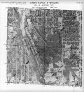
Wyoming, Walker, Grand Rapids T6N-R12W |
Kent County 1966 |
Rockford Map Publishers, Inc. |
1966 |
 |
Walker, Grand Rapids T7N-R12W |
Kent County 1966 |
Rockford Map Publishers, Inc. |
1966 |
 |
Grand Rapids, Walker T7N-R11E |
Kent County 1966 |
Rockford Map Publishers, Inc. |
1966 |
 |
Paris, South Kent, Wyoming, Grand Rapids T6N-R11W |
Kent County 1966 |
Rockford Map Publishers, Inc. |
1966 |
 |
Wyoming, Walker, Grand Rapids T6N-R12W |
Kent County 1967 |
Directory Service Company |
1967 |
 |
Walker, Grand Rapids T7N-R12W |
Kent County 1967 |
Directory Service Company |
1967 |
 |
Grand Rapids, Walker T7N-R11E |
Kent County 1967 |
Directory Service Company |
1967 |
 |
Paris, South Kent, Wyoming, Grand Rapids T6N-R11W |
Kent County 1967 |
Directory Service Company |
1967 |
 |
Wyoming, Walker, Grand Rapids T6N-R12W |
Kent County 1969 |
Rockford Map Publishers, Inc. |
1969 |
 |
Paris, South Kent, Wyoming, Grand Rapids T6N-R11W |
Kent County 1969 |
Rockford Map Publishers, Inc. |
1969 |
 |
Walker, Grand Rapids T7N-R12W |
Kent County 1969 |
Rockford Map Publishers, Inc. |
1969 |
 |
Grand Rapids, Walker T7N-R11E |
Kent County 1969 |
Rockford Map Publishers, Inc. |
1969 |
 |
Wyoming, Walker, Grand Rapids T6N-R12W |
Kent County 1969 |
Directory Service Company |
1969 |
 |
Walker, Grand Rapids T7N-R12W |
Kent County 1969 |
Directory Service Company |
1969 |
 |
Grand Rapids, Walker T7N-R11E |
Kent County 1969 |
Directory Service Company |
1969 |
 |
Paris, South Kent, Wyoming, Grand Rapids T6N-R11W |
Kent County 1969 |
Directory Service Company |
1969 |
 |
Wyoming, Walker, Grand Rapids T6N-R12W |
Kent County 1971 |
Rockford Map Publishers, Inc. |
1971 |
 |
Paris, South Kent, Wyoming, Grand Rapids T6N-R11W |
Kent County 1971 |
Rockford Map Publishers, Inc. |
1971 |
 |
Walker, Grand Rapids T7N-R12W |
Kent County 1971 |
Rockford Map Publishers, Inc. |
1971 |
 |
Grand Rapids, Walker T7N-R11E |
Kent County 1971 |
Rockford Map Publishers, Inc. |
1971 |
 |
Wyoming, Walker, Grand Rapids T6N-R12W |
Kent County 1971 |
Directory Service Company |
1971 |
 |
Paris, South Kent, Wyoming, Grand Rapids T6N-R11W |
Kent County 1971 |
Directory Service Company |
1971 |
 |
Walker, Grand Rapids T7N-R12W |
Kent County 1971 |
Directory Service Company |
1971 |
 |
Grand Rapids, Walker T7N-R11E |
Kent County 1971 |
Directory Service Company |
1971 |
 |
Wyoming, Walker, Grand Rapids T6N-R12W |
Kent County 1974 |
Rockford Map Publishers, Inc. |
1974 |
 |
Paris, South Kent, Wyoming, Grand Rapids T6N-R11W |
Kent County 1974 |
Rockford Map Publishers, Inc. |
1974 |
 |
Walker, Grand Rapids T7N-R12W |
Kent County 1974 |
Rockford Map Publishers, Inc. |
1974 |
 |
Grand Rapids, Walker T7N-R11E |
Kent County 1974 |
Rockford Map Publishers, Inc. |
1974 |
 |
Wyoming, Walker, Grand Rapids T6N-R12W |
Kent County 1977 |
Rockford Map Publishers, Inc. |
1977 |
 |
Paris, South Kent, Wyoming, Grand Rapids T6N-R11W |
Kent County 1977 |
Rockford Map Publishers, Inc. |
1977 |
 |
Walker, Grand Rapids T7N-R12W |
Kent County 1977 |
Rockford Map Publishers, Inc. |
1977 |
 |
Grand Rapids, Walker T7N-R11E |
Kent County 1977 |
Rockford Map Publishers, Inc. |
1977 |
 |
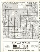
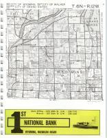
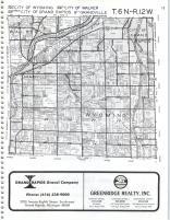
Wyoming, Walker, Grand Rapids T6N-R12W |
Kent County 1979 |
Rockford Map Publishers, Inc. |
1979 |
 |
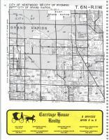
Paris, South Kent, Wyoming, Grand Rapids T6N-R11W |
Kent County 1979 |
Rockford Map Publishers, Inc. |
1979 |
 |
Walker, Grand Rapids T7N-R12W |
Kent County 1979 |
Rockford Map Publishers, Inc. |
1979 |
 |
Grand Rapids, Walker T7N-R11E |
Kent County 1979 |
Rockford Map Publishers, Inc. |
1979 |
 |
Wyoming, Walker, Grand Rapids T6N-R12W |
Kent County 1981 |
Rockford Map Publishers, Inc. |
1981 |
 |
Paris, South Kent, Wyoming, Grand Rapids T6N-R11W |
Kent County 1981 |
Rockford Map Publishers, Inc. |
1981 |
 |
Walker, Grand Rapids T7N-R12W |
Kent County 1981 |
Rockford Map Publishers, Inc. |
1981 |
 |
Grand Rapids, Walker T7N-R11E |
Kent County 1981 |
Rockford Map Publishers, Inc. |
1981 |
 |
Wyoming, Walker, Grand Rapids T6N-R12W |
Kent County 1983 |
Rockford Map Publishers, Inc. |
1983 |
 |
Paris, South Kent, Wyoming, Grand Rapids T6N-R11W |
Kent County 1983 |
Rockford Map Publishers, Inc. |
1983 |
 |
Walker, Grand Rapids T7N-R12W |
Kent County 1983 |
Rockford Map Publishers, Inc. |
1983 |
 |
Grand Rapids, Walker T7N-R11E |
Kent County 1983 |
Rockford Map Publishers, Inc. |
1983 |
 |
Wyoming, Walker, Grand Rapids T6N-R12W |
Kent County 1985 |
Rockford Map Publishers, Inc. |
1985 |
 |
Paris, South Kent, Wyoming, Grand Rapids T6N-R11W |
Kent County 1985 |
Rockford Map Publishers, Inc. |
1985 |
 |
Walker, Grand Rapids T7N-R12W |
Kent County 1985 |
Rockford Map Publishers, Inc. |
1985 |
 |
Grand Rapids, Walker T7N-R11E |
Kent County 1985 |
Rockford Map Publishers, Inc. |
1985 |
 |
Wyoming, Walker, Grand Rapids T6N-R12W |
Kent County 1988 |
Rockford Map Publishers, Inc. |
1988 |
 |
Paris, South Kent, Wyoming, Grand Rapids T6N-R11W |
Kent County 1988 |
Rockford Map Publishers, Inc. |
1988 |
 |
Walker, Grand Rapids T7N-R12W |
Kent County 1988 |
Rockford Map Publishers, Inc. |
1988 |
 |
Grand Rapids, Walker T7N-R11E |
Kent County 1988 |
Rockford Map Publishers, Inc. |
1988 |
 |
Wyoming, Walker, Grand Rapids T6N-R12W |
Kent County 1990 |
Rockford Map Publishers, Inc. |
1990 |
 |
Paris, South Kent, Wyoming, Grand Rapids T6N-R11W |
Kent County 1990 |
Rockford Map Publishers, Inc. |
1990 |
 |
Walker, Grand Rapids T7N-R12W |
Kent County 1990 |
Rockford Map Publishers, Inc. |
1990 |
 |
Grand Rapids, Walker T7N-R11E |
Kent County 1990 |
Rockford Map Publishers, Inc. |
1990 |
 |
Wyoming, Walker, Grand Rapids T6N-R12W |
Kent County 1992 |
Rockford Map Publishers, Inc. |
1992 |
 |
Paris, South Kent, Wyoming, Grand Rapids T6N-R11W |
Kent County 1992 |
Rockford Map Publishers, Inc. |
1992 |
 |
Walker, Grand Rapids T7N-R12W |
Kent County 1992 |
Rockford Map Publishers, Inc. |
1992 |
 |
Grand Rapids, Walker T7N-R11E |
Kent County 1992 |
Rockford Map Publishers, Inc. |
1992 |
 |
Wyoming, Walker, Grand Rapids T6N-R12W |
Kent County 1994 |
Rockford Map Publishers, Inc. |
1994 |
 |
Walker, Grand Rapids T7N-R12W |
Kent County 1994 |
Rockford Map Publishers, Inc. |
1994 |
 |
Grand Rapids, Walker T7N-R11E |
Kent County 1994 |
Rockford Map Publishers, Inc. |
1994 |
 |
Wyoming, Walker, Grand Rapids T6N-R12W |
Kent County 1996 |
Rockford Map Publishers, Inc. |
1996 |
 |
Walker, Grand Rapids T7N-R12W |
Kent County 1996 |
Rockford Map Publishers, Inc. |
1996 |
 |
Grand Rapids, Walker T7N-R11E |
Kent County 1996 |
Rockford Map Publishers, Inc. |
1996 |
 |
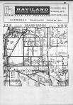
Paris Township |
Kent County 1907 |
Geo. A. Ogle and Co. |
1907 |
 |
Plate 058 - Paris Township |
Kent County and Grand Rapids 1894 |
R. L. Pol and Co. |
1894 |
|
|
Paris, South Kent, Wyoming, Grand Rapids T6N-R11W |
Kent County 1955 |
Rockford Map Publishers, Inc. |
1955 |
|
|
Paris, South Kent, Wyoming, Grand Rapids T6N-R11W |
Kent County 1966 |
Rockford Map Publishers, Inc. |
1966 |
|
|
Paris, South Kent, Wyoming, Grand Rapids T6N-R11W |
Kent County 1969 |
Rockford Map Publishers, Inc. |
1969 |
|
|
Paris, South Kent, Wyoming, Grand Rapids T6N-R11W |
Kent County 1971 |
Rockford Map Publishers, Inc. |
1971 |
|
|
Paris, South Kent, Wyoming, Grand Rapids T6N-R11W |
Kent County 1974 |
Rockford Map Publishers, Inc. |
1974 |
|
|
Paris, South Kent, Wyoming, Grand Rapids T6N-R11W |
Kent County 1977 |
Rockford Map Publishers, Inc. |
1977 |
|
|
Paris, South Kent, Wyoming, Grand Rapids T6N-R11W |
Kent County 1979 |
Rockford Map Publishers, Inc. |
1979 |
|
|
Paris, South Kent, Wyoming, Grand Rapids T6N-R11W |
Kent County 1981 |
Rockford Map Publishers, Inc. |
1981 |
|
|
Paris, South Kent, Wyoming, Grand Rapids T6N-R11W |
Kent County 1983 |
Rockford Map Publishers, Inc. |
1983 |
|
|
Paris, South Kent, Wyoming, Grand Rapids T6N-R11W |
Kent County 1985 |
Rockford Map Publishers, Inc. |
1985 |
|
|
Paris, South Kent, Wyoming, Grand Rapids T6N-R11W |
Kent County 1988 |
Rockford Map Publishers, Inc. |
1988 |
|
|
Paris, South Kent, Wyoming, Grand Rapids T6N-R11W |
Kent County 1990 |
Rockford Map Publishers, Inc. |
1990 |
|
|
Paris, South Kent, Wyoming, Grand Rapids T6N-R11W |
Kent County 1992 |
Rockford Map Publishers, Inc. |
1992 |
 |
Paris Township |
Kent County 1876 |
H. Belden and Co. |
1876 |
|
|
Paris, South Kent, Wyoming, Grand Rapids T6N-R11W |
Kent County 1967 |
Directory Service Company |
1967 |
|
|
Paris, South Kent, Wyoming, Grand Rapids T6N-R11W |
Kent County 1969 |
Directory Service Company |
1969 |
|
|
Paris, South Kent, Wyoming, Grand Rapids T6N-R11W |
Kent County 1971 |
Directory Service Company |
1971 |
|
|
Paris Township, Grand Rapids, Ponce de Leon, Crosby, Bowen Sta. |
Kent County 1920c |
W.W. Hixson & Co. |
1920 |
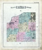 |
Plate 057 - Wyoming Township |
Kent County and Grand Rapids 1894 |
R. L. Pol and Co. |
1894 |
|
|
Wyoming, Walker, Grand Rapids T6N-R12W |
Kent County 1955 |
Rockford Map Publishers, Inc. |
1955 |
|
|
Wyoming, Walker, Grand Rapids T6N-R12W |
Kent County 1966 |
Rockford Map Publishers, Inc. |
1966 |
|
|
Wyoming, Walker, Grand Rapids T6N-R12W |
Kent County 1969 |
Rockford Map Publishers, Inc. |
1969 |
|
|
Wyoming, Walker, Grand Rapids T6N-R12W |
Kent County 1971 |
Rockford Map Publishers, Inc. |
1971 |
|
|
Wyoming, Walker, Grand Rapids T6N-R12W |
Kent County 1974 |
Rockford Map Publishers, Inc. |
1974 |
|
|
Wyoming, Walker, Grand Rapids T6N-R12W |
Kent County 1977 |
Rockford Map Publishers, Inc. |
1977 |
|
|
Wyoming, Walker, Grand Rapids T6N-R12W |
Kent County 1979 |
Rockford Map Publishers, Inc. |
1979 |
|
|
Wyoming, Walker, Grand Rapids T6N-R12W |
Kent County 1981 |
Rockford Map Publishers, Inc. |
1981 |
|
|
Wyoming, Walker, Grand Rapids T6N-R12W |
Kent County 1983 |
Rockford Map Publishers, Inc. |
1983 |
|
|
Wyoming, Walker, Grand Rapids T6N-R12W |
Kent County 1985 |
Rockford Map Publishers, Inc. |
1985 |
|
|
Wyoming, Walker, Grand Rapids T6N-R12W |
Kent County 1988 |
Rockford Map Publishers, Inc. |
1988 |
|
|
Wyoming, Walker, Grand Rapids T6N-R12W |
Kent County 1990 |
Rockford Map Publishers, Inc. |
1990 |
|
|
Wyoming, Walker, Grand Rapids T6N-R12W |
Kent County 1992 |
Rockford Map Publishers, Inc. |
1992 |
|
|
Wyoming, Walker, Grand Rapids T6N-R12W |
Kent County 1994 |
Rockford Map Publishers, Inc. |
1994 |
|
|
Wyoming, Walker, Grand Rapids T6N-R12W |
Kent County 1996 |
Rockford Map Publishers, Inc. |
1996 |
|
|
Wyoming, Walker, Grand Rapids T6N-R12W |
Kent County 1967 |
Directory Service Company |
1967 |
|
|
Wyoming, Walker, Grand Rapids T6N-R12W |
Kent County 1969 |
Directory Service Company |
1969 |
|
|
Wyoming, Walker, Grand Rapids T6N-R12W |
Kent County 1971 |
Directory Service Company |
1971 |
|
|
Wyoming Township, Grandville, Ivanrest, Grand Rapids, Beverly, Barendsenville |
Kent County 1920c |
W.W. Hixson & Co. |
1920 |
|
|
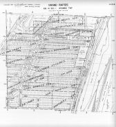
Plate 054 - Grand Rapids Township |
Kent County and Grand Rapids 1894 |
R. L. Pol and Co. |
1894 |
|
|
Grand Rapids, Walker T7N-R11E |
Kent County 1955 |
Rockford Map Publishers, Inc. |
1955 |
|
|
Grand Rapids, Walker T7N-R11E |
Kent County 1966 |
Rockford Map Publishers, Inc. |
1966 |
|
|
Grand Rapids, Walker T7N-R11E |
Kent County 1969 |
Rockford Map Publishers, Inc. |
1969 |
|
|
Grand Rapids, Walker T7N-R11E |
Kent County 1971 |
Rockford Map Publishers, Inc. |
1971 |
|
|
Grand Rapids, Walker T7N-R11E |
Kent County 1974 |
Rockford Map Publishers, Inc. |
1974 |
|
|
Grand Rapids, Walker T7N-R11E |
Kent County 1977 |
Rockford Map Publishers, Inc. |
1977 |
|
|
Grand Rapids, Walker T7N-R11E |
Kent County 1979 |
Rockford Map Publishers, Inc. |
1979 |
|
|
Grand Rapids, Walker T7N-R11E |
Kent County 1981 |
Rockford Map Publishers, Inc. |
1981 |
|
|
Grand Rapids, Walker T7N-R11E |
Kent County 1983 |
Rockford Map Publishers, Inc. |
1983 |
|
|
Grand Rapids, Walker T7N-R11E |
Kent County 1985 |
Rockford Map Publishers, Inc. |
1985 |
|
|
Grand Rapids, Walker T7N-R11E |
Kent County 1988 |
Rockford Map Publishers, Inc. |
1988 |
|
|
Grand Rapids, Walker T7N-R11E |
Kent County 1990 |
Rockford Map Publishers, Inc. |
1990 |
|
|
Grand Rapids, Walker T7N-R11E |
Kent County 1992 |
Rockford Map Publishers, Inc. |
1992 |
|
|
Grand Rapids, Walker T7N-R11E |
Kent County 1994 |
Rockford Map Publishers, Inc. |
1994 |
|
|
Grand Rapids, Walker T7N-R11E |
Kent County 1996 |
Rockford Map Publishers, Inc. |
1996 |
|
|
Grand Rapids Township |
Kent County 1876 |
H. Belden and Co. |
1876 |
|
|
Grand Rapids, Walker T7N-R11E |
Kent County 1967 |
Directory Service Company |
1967 |
|
|
Grand Rapids, Walker T7N-R11E |
Kent County 1969 |
Directory Service Company |
1969 |
|
|
Grand Rapids, Walker T7N-R11E |
Kent County 1971 |
Directory Service Company |
1971 |
|
|
Walker, Grand Rapids T7N-R12W |
Kent County 1955 |
Rockford Map Publishers, Inc. |
1955 |
|
|
Walker, Grand Rapids T7N-R12W |
Kent County 1966 |
Rockford Map Publishers, Inc. |
1966 |
|
|
Walker, Grand Rapids T7N-R12W |
Kent County 1969 |
Rockford Map Publishers, Inc. |
1969 |
|
|
Walker, Grand Rapids T7N-R12W |
Kent County 1971 |
Rockford Map Publishers, Inc. |
1971 |
|
|
Walker, Grand Rapids T7N-R12W |
Kent County 1974 |
Rockford Map Publishers, Inc. |
1974 |
|
|
Walker, Grand Rapids T7N-R12W |
Kent County 1977 |
Rockford Map Publishers, Inc. |
1977 |
|
|
Walker, Grand Rapids T7N-R12W |
Kent County 1979 |
Rockford Map Publishers, Inc. |
1979 |
|
|
Walker, Grand Rapids T7N-R12W |
Kent County 1981 |
Rockford Map Publishers, Inc. |
1981 |
|
|
Walker, Grand Rapids T7N-R12W |
Kent County 1983 |
Rockford Map Publishers, Inc. |
1983 |
|
|
Walker, Grand Rapids T7N-R12W |
Kent County 1985 |
Rockford Map Publishers, Inc. |
1985 |
|
|
Walker, Grand Rapids T7N-R12W |
Kent County 1988 |
Rockford Map Publishers, Inc. |
1988 |
|
|
Walker, Grand Rapids T7N-R12W |
Kent County 1990 |
Rockford Map Publishers, Inc. |
1990 |
|
|
Walker, Grand Rapids T7N-R12W |
Kent County 1992 |
Rockford Map Publishers, Inc. |
1992 |
|
|
Walker, Grand Rapids T7N-R12W |
Kent County 1994 |
Rockford Map Publishers, Inc. |
1994 |
|
|
Walker, Grand Rapids T7N-R12W |
Kent County 1996 |
Rockford Map Publishers, Inc. |
1996 |
|
|
Walker, Grand Rapids T7N-R12W |
Kent County 1967 |
Directory Service Company |
1967 |
|
|
Walker, Grand Rapids T7N-R12W |
Kent County 1969 |
Directory Service Company |
1969 |
|
|
Walker, Grand Rapids T7N-R12W |
Kent County 1971 |
Directory Service Company |
1971 |

 Cart
Cart