,final/TileGroup0/0-0-0.jpg) |
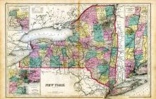
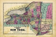
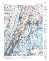
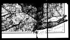
2, New York New Map, Adjacent Cities (Section 2) |
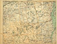
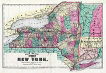
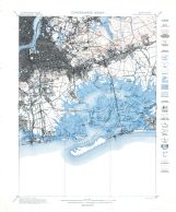
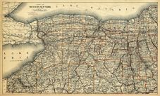
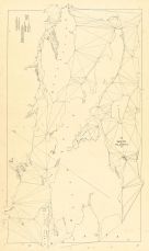
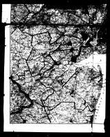
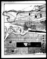
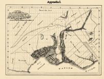
Hudson River Valley 1891 |
Watson & Co. |
1891 |
,final/TileGroup0/0-0-0.jpg) |
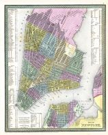
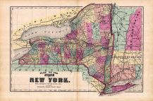
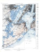
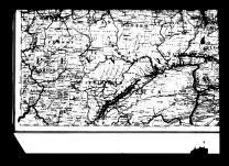
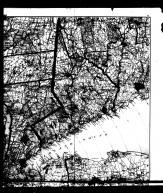
1, New York Map, Brooklyn, Jersey City (Section 1) |
Hudson River Valley 1891 |
Watson & Co. |
1891 |
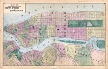 |
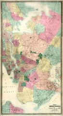
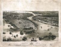
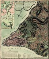
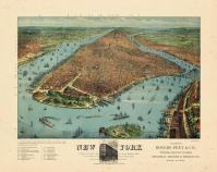
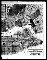
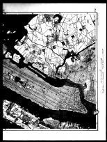
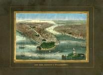
New York and Brooklyn Cities Central Portions Map |
Long Island 1873 |
Beers, Comstock & Cline |
1873 |
 |
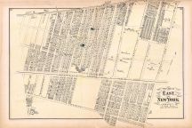
New York East 1 |
Long Island 1873 |
Beers, Comstock & Cline |
1873 |
 |
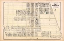
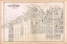
New York East 2 |
Long Island 1873 |
Beers, Comstock & Cline |
1873 |
 |
New York East 3 |
Long Island 1873 |
Beers, Comstock & Cline |
1873 |
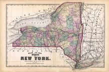 |
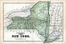
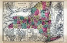
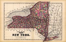
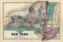
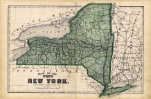
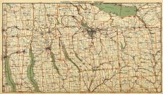
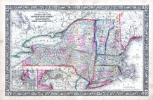
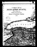
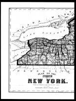
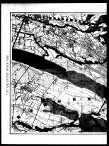
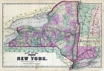
State Map New York |
Long Island 1873 |
Beers, Comstock & Cline |
1873 |
 |
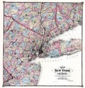
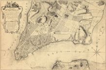
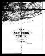
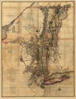
New York & Brooklyn Plan |
New York and its Vicinity 1867 |
F. W. Beers, A. D. Ellis & G. C. Soulle |
1867 |
 |
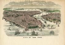
New York |
New York and its Vicinity 1867 |
F. W. Beers, A. D. Ellis & G. C. Soulle |
1867 |
,final/TileGroup0/0-0-0.jpg) |
Westchester, Westfarms, Morrisania Plan (Westchester Co, & Part Of New York Co.) |
New York and its Vicinity 1867 |
F. W. Beers, A. D. Ellis & G. C. Soulle |
1867 |
 |
New York City 1850 Map |
New York City 1850 |
Thomas Cowperthwait and Company |
1850 |
 |
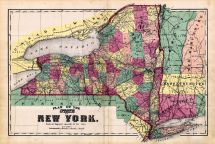
New York State Map - Plan |
Onondaga County 1874 |
Walker Bros. & Co. |
1874 |
 |
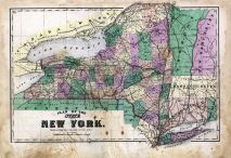
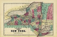
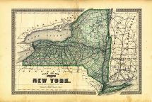
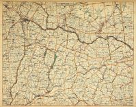
State Map New York 1 |
Steuben County 1873 |
D. G. Beers & Co. |
1873 |
 |
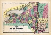
State Map New York 2 |
Steuben County 1873 |
D. G. Beers & Co. |
1873 |
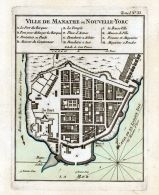 |
Bellin - New York - Ville de Manathe Nouvelle - Yorc 1764 |
Bellin - New York - Ville de Manathe Nouvelle-Yorc 1764 |
Jacques-Nicolas Bellin |
1764 |
 |
New York City and County 1882 Published by Colton |
New York City Map 1882 Published by Colton |
Colton |
1882 |
 |
New York City 1867 Dripps Composite 17x57 |
New York City 1867 Dripps Composite |
Matthew Dripps |
1867 |
 |
New York City 1867 Dripps Composite 24x81 |
New York City 1867 Dripps Composite |
Matthew Dripps |
1867 |
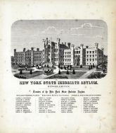 |
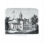
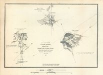
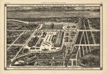
New York State Inebriate Asylum |
Broome County 1866 |
Beers & Beers |
1866 |
 |
State Map of New York |
Broome County 1876 |
Everts, Ensign & Everts |
1876 |
 |
New York State Inebriate Asylum |
Broome County 1876 |
Everts, Ensign & Everts |
1876 |
 |
New York Map |
Rockland County 1876 |
F. A. Davis & Co. |
1876 |
 |
New York City 1867 Dripps Central Park Composite A |
New York City 1867 Dripps Central Park Composite |
Matthew Dripps |
1867 |
 |
New York City 1867 Dripps Central Park Composite B |
New York City 1867 Dripps Central Park Composite |
Matthew Dripps |
1867 |
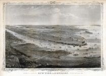 |
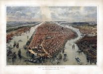
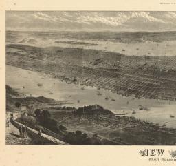
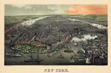
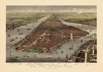
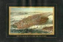
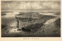
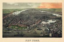
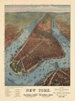
New York 1869 Bird's Eye View |
New York 1869 Bird's Eye View |
New York Manual 1869 |
1869 |
 |
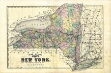
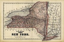
New York State Map |
Chemung County 1869 |
Frederick W. Beers |
1869 |
 |
New York State Map |
Broome County 1908 |
Northwest Publishing Co. |
1908 |
 |
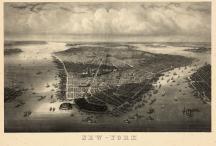
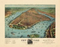
New York City 1865 Bird's Eye View 17x23 |
New York City 1865 Bird's Eye View |
John Bachman |
1865 |
 |
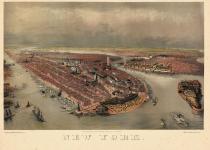
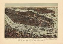
New York City and Brooklyn 1851 Bird's Eye View 17x22 |
New York City and Brooklyn 1851 Bird's Eye View |
John Bachman |
1851 |
 |
Bellin - New York - Baye et Port d'Yorc 1764 |
Bellin - New York - Baye et Port d'Yorc 1764 |
Jacques-Nicolas Bellin |
1764 |
 |
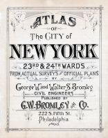
New York City 1897 Bird's Eye View of 23rd and 24th Wards 17x60 |
New York City 1897 Bird's Eye View of 23rd and 24th Wards |
William W. Klein |
1897 |
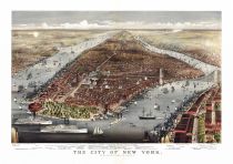 |
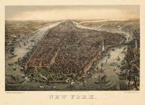
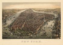
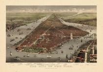
New York City 1876 Bird's Eye View 17x25 |
New York City 1876 Bird's Eye View |
Parsons and Atwater |
1876 |
 |
New York State Map |
Wayne County 1874 |
D. G. Beers & Co. |
1874 |
 |
New York - Plan Map |
Tioga County 1869 |
F. W. Beers & Co. |
1869 |
 |
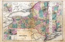
New York State Map, Hudson River Valley, Niagara River and Vicinity |
Cortland County 1876 |
Everts, Ensign and Everts |
1876 |
 |
New York State Map |
Herkimer County 1868 |
Stranahan & Nichols |
1868 |
 |
New York State - Plan Map |
Otsego County 1868 |
F. W. Beers |
1868 |
 |
Albany, New York State Capitol |
Albany and Schenectady Counties 1866 |
Stone & Stewart |
1866 |
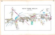 |
New York Mills |
Oneida County 1907 |
Century Map Co. |
1907 |
 |
New York State Plan Map |
Allegany County 1869 |
D. G. Beers & Co. |
1869 |
 |
New York State - Plan Map |
Livingston County 1872 |
F. W. Beers & Co. |
1872 |
 |
New York State - Plan |
Madison County 1875 |
Pomeroy, Whitman & Co. |
1875 |
 |
New York State - Plan |
Schuyler County 1874 |
Pomeroy, Whitman & Co. |
1874 |
 |
New York State - Plan Map |
Oneida County 1874 |
D. G. Beers & Co. |
1874 |
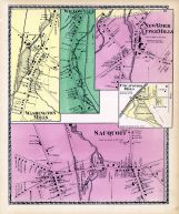 |
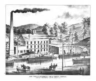
Washington Mills, Willowvale, Utica Cotton Mills, New York Upper Mills, Sauquoit |
Oneida County 1874 |
D. G. Beers & Co. |
1874 |
 |
Whitestown, New York Mills |
Oneida County 1874 |
D. G. Beers & Co. |
1874 |
 |
New York State - Plan |
Ontario County 1874 |
Pomeroy, Whitman & Co. |
1874 |
 |
New York |
Genesee County 1876 |
Century Map Co. |
1876 |
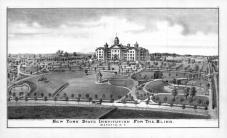 |
New York State Institution for the Blind, P.F. Goist, Batavia, N.Y. |
Genesee County 1876 |
Century Map Co. |
1876 |
 |
New York State - Plan |
Erie County 1880 |
F. W. Beers & Co. |
1880 |
 |
New York State Map |
Franklin County 1876 |
D. G. Beers & Co. |
1876 |
 |
New York State - Plan |
Sullivan County 1875 |
Walker and Jewett |
1875 |
 |
New York State Plan |
Columbia County 1873 |
D. G. Beers & Co. |
1873 |
 |
New York State - Plan |
Orange County 1875 |
Andreas, Baskin & Burr |
1875 |
 |
New York State - Plan |
Rensselaer County 1876 |
F. W. Beers & Co. |
1876 |
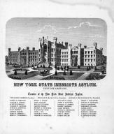 |
New York Inebriate Asylum, Binghampton, Parker, McCoun, Williams, Dickinson, Tailer, Dodge, Alexander, Osborn |
Tompkins County 1866 |
Stone & Stewart |
1866 |
 |
Niagara Falls - New York State Reservation |
Niagara County 1908 |
Century Map Co. |
1908 |
 |
New York |
Yates County 1876 |
Everts, Ensign and Everts |
1876 |
 |
New York State Map |
Cayuga County 1875 |
Walker and Jewett |
1875 |
 |
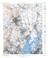
New York, Oswego, Buffalo, Rochester, Syracuse, Albany, Troy |
Montgomery and Fulton Counties 1868 |
J. Jay Stranahan and Beach Nichols |
1868 |
 |
New York - Fordham Road |
New York 1950c Nirenstein City Maps |
Nirenstein |
1950 |
 |
New York City 1905c Bird's Eye View 17x24 |
New York City 1905c Bird's Eye View |
Joseph Koehler |
1905 |
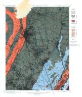 |
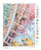
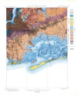
Historical Geology Sheet 001 - New Jersey - New York Paterson Quadrangle |
New York City 1902 Geological Atlas of the United States Vol 83 |
U.S. Geological Survey |
1902 |
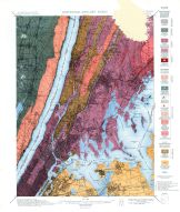 |
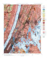
Historical Geology Sheet 002 - New York - New Jersey Harlem Quadrangle |
New York City 1902 Geological Atlas of the United States Vol 83 |
U.S. Geological Survey |
1902 |
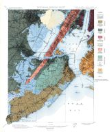 |
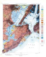
Historical Geology Sheet 003 - New Jersey - New York Staten Island Quadrangle |
New York City 1902 Geological Atlas of the United States Vol 83 |
U.S. Geological Survey |
1902 |
 |
Historical Geology Sheet 004 - New York Brooklyn Quadrangle |
New York City 1902 Geological Atlas of the United States Vol 83 |
U.S. Geological Survey |
1902 |
 |
Structure Section Sheet - New York - New Jersey Harlem Quadrangle |
New York City 1902 Geological Atlas of the United States Vol 83 |
U.S. Geological Survey |
1902 |
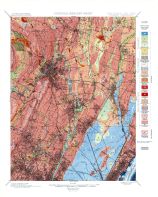 |
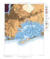
Surficial Geology Sheet 001 - New Jersey - New York Paterson Quadrangle |
New York City 1902 Geological Atlas of the United States Vol 83 |
U.S. Geological Survey |
1902 |
 |
Surficial Geology Sheet 002 - New York - New Jersey Harlem Quadrangle |
New York City 1902 Geological Atlas of the United States Vol 83 |
U.S. Geological Survey |
1902 |
 |
Surficial Geology Sheet 003 - New Jersey - New York Staten Island Quadrangle |
New York City 1902 Geological Atlas of the United States Vol 83 |
U.S. Geological Survey |
1902 |
 |
Surficial Geology Sheet 004 - New York Brooklyn Quadrangle |
New York City 1902 Geological Atlas of the United States Vol 83 |
U.S. Geological Survey |
1902 |
 |
Topographic Sheet 001 - New Jersey - New York Paterson Quadrangle |
New York City 1902 Geological Atlas of the United States Vol 83 |
U.S. Geological Survey |
1902 |
 |
Topographic Sheet 002 - New York - New Jersey Harlem Quadrangle |
New York City 1902 Geological Atlas of the United States Vol 83 |
U.S. Geological Survey |
1902 |
 |
Topographic Sheet 003 - New Jersey - New York Staten Island Quadrangle |
New York City 1902 Geological Atlas of the United States Vol 83 |
U.S. Geological Survey |
1902 |
 |
Topographic Sheet 004 - New York Brooklyn Quadrangle |
New York City 1902 Geological Atlas of the United States Vol 83 |
U.S. Geological Survey |
1902 |
 |
New York Cement Company at Le Fever Falls |
Ulster County 1875 |
Walker and Jewett |
1875 |
 |
New York and Rosedale Lime & Cement Company |
Ulster County 1875 |
Walker and Jewett |
1875 |
 |
New York Lake Section 20 |
New York State 1890 to 1908 Walker Maps |
Geo. H. Walker & Co. Boston |
1890 |
 |
New York Mokawk Section |
New York State 1890 to 1908 Walker Maps |
Geo. H. Walker & Co. Boston |
1890 |
 |
Western New York |
New York State 1890 to 1908 Walker Maps |
Geo. H. Walker & Co. Boston |
1890 |
 |
New York Bay - Staten Island - Point Comfort Chart 1851 New York and New Jersey |
New York Bay and Harbor 1866 Number 20 - New York and New Jersey |
U. S. Coast and Survey |
1866 |
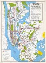 |
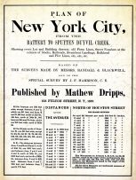
Page 004 - New York Subway Map |
New York City 1949 Five Boroughs Street Atlas |
Hagstrom - Cruikshank Company |
1949 |
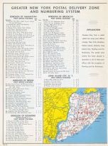 |
Page 006 - New York Postal Delivery Zones |
New York City 1949 Five Boroughs Street Atlas |
Hagstrom - Cruikshank Company |
1949 |
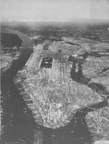 |
Aerial View New York City |
New York City 1949 Five Boroughs Street Atlas |
Hagstrom - Cruikshank Company |
1949 |
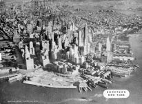 |
Aerial View Downtown New York |
New York City 1949 Five Boroughs Street Atlas |
Hagstrom - Cruikshank Company |
1949 |
 |
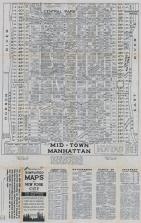
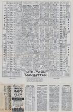
Aerial View Mid Town New York |
New York City 1949 Five Boroughs Street Atlas |
Hagstrom - Cruikshank Company |
1949 |
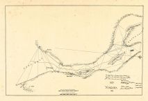 |
Niagara - Lake Erie - Grand Island Chart 1819 New York |
Niagara - Lake Erie - Grand Island Chart 1819 New York |
Unattributed |
1819 |
 |
New York State Map |
Chautauqua County 1881 |
F.W. Beers and Co. |
1881 |
 |
Grand Island - Lake Ontario - St Lawrence Chart 1818 New York |
Grand Island - Lake Ontario - St. Lawrence Chart 1818 New York |
Peter Porter |
1818 |
 |
New York, Brooklyn, Manhattan, Jersey City, Hoboken 1864 Mitchell Plate |
New York, Brooklyn, Manhattan, Jersey City, Hoboken 1864 Mitchell Plate |
S. Augustus Mitchell |
1864 |
 |
New York, New Hampshire, Vermont 1864 Mitchell Plate |
New York, New Hampshire, Vermont 1864 Mitchell Plate |
S. Augustus Mitchell |
1864 |
 |
New York City 1775 |
New York City 1775 |
Montresor, John |
1775 |
 |
New York City 1776 From 1767 Survey |
New York City 1776 From 1767 Survey |
Ratzer, Bernard |
1776 |
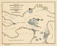 |
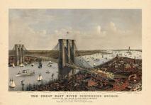
New York - East River and Hell Gate 1886 |
New York - East River and Hell Gate 1886 |
Brig. Gen. John Newton |
1886 |
 |
New York City 1891 Bird's Eye View on Playbill 24x34 |
New York City 1891 Bird's Eye View on Playbill |
Howard P. Taylor |
1891 |
 |
New York City 1876 Bird's Eye View Published by Loudan 24x50 |
New York City 1876 Bird's Eye View Published by Loudan |
Loudan, Robert |
1876 |
 |
New York City 1874 Bird's Eye View 24x32 |
New York City 1874 Bird's Eye View |
G. Schlegel |
1874 |
 |
New York City 1873 Bird's Eye View Published by Schlegel 24x32 |
New York City 1873 Bird's Eye View Published by Schlegel |
G. Schlegel |
1873 |
 |
New York City 1873 Bird's Eye View Published by Mayer and Sons 24x35 |
New York City 1873 Bird's Eye View Published by Mayer and Sons |
Ferd. Mayer & Sons |
1873 |
 |
New York City 1851 Bird's Eye View 24x34 |
New York City 1851 Bird's Eye View |
Heine, J. Kummer & Dopler |
1851 |
 |
New York City 1907 Bird's Eye View 24x32 |
New York City 1907 Bird's Eye View |
August R. Ohman |
1907 |
 |
New York City 1892 Bird's Eye View 24x33 |
New York City 1892 Bird's Eye View |
Parsons & Atwater |
1892 |
 |
New York City 1885 Bird's Eye View 24x34 |
New York City 1885 Bird's Eye View |
Currier & Ives |
1885 |
 |
New York City 1884 Bird's Eye View 24x33 |
New York City 1884 Bird's Eye View |
Currier & Ives |
1884 |
 |
New York City 1883 Bird's Eye View of World's Fair 24x33 |
New York City 1883 Bird's Eye View of World's Fair |
Stranders, Walter |
1883 |
 |
New York City 1879 Bird's Eye View Published by Rogers and Peet 24x29 |
New York City 1879 Bird's Eye View Published by Rogers and Peet |
Rogers, Peet, and Co. |
1879 |
 |
New York City 1879 Bird's Eye View Published by Williams 24x31 |
New York City 1879 Bird's Eye View Published by Williams |
J. W. Williams |
1879 |
 |
New York State Map - Above Left |
Columbia County 1888 |
Beers, Ellis & Co. |
1888 |
 |
New York State Map - Above Right |
Columbia County 1888 |
Beers, Ellis & Co. |
1888 |
 |
New York State Map - Below Left |
Columbia County 1888 |
Beers, Ellis & Co. |
1888 |
 |
New York State Map - Below Right |
Columbia County 1888 |
Beers, Ellis & Co. |
1888 |
 |
New York State Map - Right |
Clinton County 1869 Microfilm |
F. W. Beers, A. D. Ellis & G. G. Soule |
1869 |
 |
New York State Map - Left |
Clinton County 1869 Microfilm |
F. W. Beers, A. D. Ellis & G. G. Soule |
1869 |
 |
New York State Map Right |
Warren County 1876 |
F. W. Beers & Co. |
1876 |
 |
New York State Map Left |
Warren County 1876 |
F. W. Beers & Co. |
1876 |
 |
New York State Map - West |
Rockland County 1875 |
Walker and Jewett |
1875 |
 |
New York State Map - East |
Rockland County 1875 |
Walker and Jewett |
1875 |
 |
New York Map - Below Right |
Westchester County 1872 |
J. B. Beers |
1872 |
 |
New York Map - Below Left |
Westchester County 1872 |
J. B. Beers |
1872 |
 |
New York Map - Above Right |
Westchester County 1872 |
J. B. Beers |
1872 |
 |
New York Map - Above Left |
Westchester County 1872 |
J. B. Beers |
1872 |
 |
New York City and Brooklyn - Below |
Westchester County 1872 |
J. B. Beers |
1872 |
 |
New York City and Brooklyn - Above |
Westchester County 1872 |
J. B. Beers |
1872 |
 |
New York - Right |
Westchester County 1893 |
Julius Bien and Co. |
1893 |
 |
New York - Left |
Westchester County 1893 |
Julius Bien and Co. |
1893 |
 |
New York State Map |
Niagara and Orleans County 1875 |
D. G. Beers & Co. |
1875 |
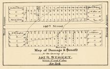 |
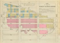
New York 1871 Landowners on 107th Street |
New York 1871 Landowners on 107th Street from Directory of Dutch Grants 1899 |
Commissioners Report |
1899 |
 |
New York 1889c Bay of Hellagate and McGown Farm |
New York 1889c Bay of Hellagate and McGown Farm from Directory of Dutch Grants 1899 |
Wm. J. Haskin for John W. Pirsson |
1899 |
 |
New York 1778 |
New York City 1778 from Manual of the Corporation of the City of New York 1869 |
Thos. Kitchen Senr. |
1869 |
 |
New York Province 1779 Land Tracts new 24x31 |
New York Province 1779 Land Tracts |
Claude Joseph Sauthier |
1779 |
 |
New York Province 1779 Land Tracts new |
New York Province 1779 Land Tracts |
Claude Joseph Sauthier |
1779 |
 |
Railroads - Westchester County and New York City |
Westchester County 1953 |
Hangstrom Company, Inc. |
1953 |
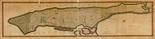 |
New York City 1807 Island of Manhattan 16x63 |
New York City 1807 Island of Manhattan |
Wm. Bridges |
1807 |
 |
New York City 1807 Island of Manhattan 23x90 |
New York City 1807 Island of Manhattan |
Wm. Bridges |
1807 |
 |
New York City 1639 Manatvs gelegen op de Noot Riuier |
New York City 1639 Manatvs gelegen op de Noot Riuier |
Vinckeboons, Joan |
1639 |
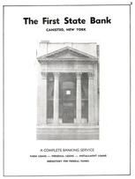 |
The First State Bank, Canisteo, New York |
Steuben County 1961 |
Empire City Directories |
1961 |
 |
New York 1854 State Map with view of Niagara Falls - 10x014 |
New York 1854 State Map with view of Niagara Falls - 10x014 |
Charles Magnus |
1854 |
 |
New York 1861 to 1865 Bird's Eye View with Eagle - 81x290.2 |
New York 1861 to 1865 Bird's Eye View with Eagle - 81x290.2 |
Charles Magnus |
[1861-1865] |
 |
New York City 1850 to 1899 Bird's Eye View from Southeast - 68x122.1 |
New York City 1850 to 1899 Bird's Eye View from Southeast - 68x122.1 |
Charles Magnus |
Unattributed |
 |
New York City 1850 to 1899 Bird's Eye View from Southwest - 04x083.8 |
New York City 1850 to 1899 Bird's Eye View from Southwest - 04x083.8 |
Charles Magnus |
Unattributed |
 |
New York City 1850 to 1899 Bird's Eye View from the South - 68x122.2 |
New York City 1850 to 1899 Bird's Eye View from the South - 68x122.2 |
Charles Magnus |
Unattributed |
 |
New York City 1850 to 1899 Bird's Eye View from the Southeast with incomplete border - 09x048.3 |
New York City 1850 to 1899 Bird's Eye View from the Southeast with incomplete border - 09x048.3 |
Charles Magnus |
Unattributed |
 |
New York City 1850 to 1899 Broadway, Bowling Green, Battery Park - 09x048.4 |
New York City 1850 to 1899 Broadway, Bowling Green, Battery Park - 09x048.4 |
Charles Magnus |
Unattributed |
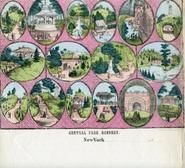 |
New York City 1850 to 1899 Central Park Scenery - 09x048.6 |
New York City 1850 to 1899 Central Park Scenery - 09x048.6 |
Charles Magnus |
Unattributed |
 |
New York City 1850 to 1899 Grand Street, East Broadway Junction to Williamsburgh Ferry - 09x048.5 |
New York City 1850 to 1899 Grand Street, East Broadway Junction to Williamsburgh Ferry - 09x048.5 |
Charles Magnus |
Unattributed |
 |
New York City 1850 to 1899 Great Washington Bridge - 09x048.7 |
New York City 1850 to 1899 Great Washington Bridge - 09x048.7 |
Charles Magnus |
ca. 1889 |
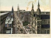 |
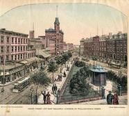
New York City 1850 to 1899 Uptown View Fifth Ave from Forty-Send Street - 09x079.2 |
New York City 1850 to 1899 Uptown View Fifth Ave from Forty-Send Street - 09x079.2 |
Charles Magnus |
Unattributed |
 |
New York City 1850 to 1899 View of Bowling Green - 91x082.2 |
New York City 1850 to 1899 View of Bowling Green - 91x082.2 |
Charles Magnus |
Unattributed |
 |
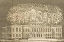
Erie Canal 1825 View of Fireworks at New York City Hall - 08L001-1 |
Erie Canal 1825 Views from... celebration of the completion of the New York canals |
Colden, Cadwallader D. |
1825 |
 |
Erie Canal 1825 View of Fireworks at New York City Hall Cropped - 08L001-2 |
Erie Canal 1825 Views from... celebration of the completion of the New York canals |
Colden, Cadwallader D. |
1825 |
 |
New York State Map |
Clinton County 1869 |
F. W. Beers, A. D. Ellis & G. G. Soule |
1869 |
 |
New York City 1776c Showing British and American Troop Positions - APSdigobj3471 |
New York City 1776c Showing British and American Troop Positions |
Peale, Charles Willson, 1741-1827 |
1776c |
 |
New York City 1830c - APSdigobj3528 |
New York City 1830c |
J .A. |
1830c |

 Cart
Cart


,final/TileGroup0/0-0-0.jpg)


,final/TileGroup0/0-0-0.jpg)