
 Cart
Cart
|
ITEM #OL1298
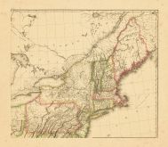
Map - Page 2 -From UNITED STATES of Nth. AMERICA/-/CARTE des ETATS-UNIS/DE/L'AMERIQUE SEPTENTRIONALE/COPIEE et GRAVEE sur celle D'ARROWSMITH/Corrigee et considerablement augmentee//Par P.F. TARDIEUA PARIS/1812 Published by TARDIEU, P.F. [AFTER A. ARROWSMITH] in 1812 |
 Buy this Map »


Map Information
Full Title: Map - Page 2 - UNITED STATES of Nth. AMERICA/-/CARTE des ETATS-UNIS/DE/L'AMERIQUE SEPTENTRIONALE/COPIEE et GRAVEE sur celle D'ARROWSMITH/Corrigee et considerablement augmentee//Par P.F. TARDIEUA PARIS/1812
Full Atlas Title: UNITED STATES of Nth. AMERICA/-/CARTE des ETATS-UNIS/DE/L'AMERIQUE SEPTENTRIONALE/COPIEE et GRAVEE sur celle D'ARROWSMITH/Corrigee et considerablement augmentee//Par P.F. TARDIEUA PARIS/1812
Location 1: Unattributed
Location 2: New Hampshire, Massachusetts, Maine, Connecticut, New Jersey, New York, Pennsylvania, Rhode Island, Vermont
Publish Date: 1812
Publisher: TARDIEU, P.F. [AFTER A. ARROWSMITH]
Number Maps in the Atlas: 4
Map Original Width: 31.23"
Map Original Height: 27.23"
Item Number: OL1298
Collection: Osher Map Library Antique Maps Collection
Image Quality: High quality scan of original that is perfect for printed fine-art quality reproduction.
Category:
Maps and/or Atlas Quality:
TAGS:
Full Atlas Title: UNITED STATES of Nth. AMERICA/-/CARTE des ETATS-UNIS/DE/L'AMERIQUE SEPTENTRIONALE/COPIEE et GRAVEE sur celle D'ARROWSMITH/Corrigee et considerablement augmentee//Par P.F. TARDIEUA PARIS/1812
Location 1: Unattributed
Location 2: New Hampshire, Massachusetts, Maine, Connecticut, New Jersey, New York, Pennsylvania, Rhode Island, Vermont
Publish Date: 1812
Publisher: TARDIEU, P.F. [AFTER A. ARROWSMITH]
Number Maps in the Atlas: 4
Map Original Width: 31.23"
Map Original Height: 27.23"
Item Number: OL1298
Collection: Osher Map Library Antique Maps Collection
Image Quality: High quality scan of original that is perfect for printed fine-art quality reproduction.
Category:
historic maps, old maps
Maps and/or Atlas Quality:
TAGS:
Source Institution:

Osher Map Library Smith Center For Cartographic Education
Souce Media:
Original Document
Osher Map Library Smith Center For Cartographic Education
Souce Media:
Original Document
| This antique map (Map - Page 2) and atlas (UNITED STATES of Nth. AMERICA/-/CARTE des ETATS-UNIS/DE/L'AMERIQUE SEPTENTRIONALE/COPIEE et GRAVEE sur celle D'ARROWSMITH/Corrigee et considerablement augmentee//Par P.F. TARDIEUA PARIS/1812) are part of the Historic Map Works, Residential Genealogy™ historical map collection, the largest digital collection of rare, ancient, old, historical, cadastral and antiquarian maps of its type. We currently have over 1,662,956 images available online. You can read about the collection or browse the entire collection. |