
 Cart
Cart
|
ITEM #OL1403
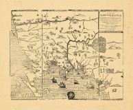
Map - Page 1 -From A MAP OF/NEW ENGLAND,/Being the first that ever was here cut, and done by/the best Pattern that could be had, which being in/some places defective, it made the other less exact-/distance of places. Published by FOSTER, JOHN in 1677 |
 Buy this Map »


Map Information
Full Title: Map - Page 1 - A MAP OF/NEW ENGLAND,/Being the first that ever was here cut, and done by/the best Pattern that could be had, which being in/some places defective, it made the other less exact-/distance of places.
Full Atlas Title: A MAP OF/NEW ENGLAND,/Being the first that ever was here cut, and done by/the best Pattern that could be had, which being in/some places defective, it made the other less exact-/distance of places.
Location 1: Unattributed
Location 2: Maine, Massachusetts
Publish Date: 1677
Publisher: FOSTER, JOHN
Number Maps in the Atlas: 1
Map Original Width: 17.62"
Map Original Height: 14.49"
Item Number: OL1403
Collection: Osher Map Library Antique Maps Collection
Image Quality: High quality scan of original that is perfect for printed fine-art quality reproduction.
Category:
Maps and/or Atlas Quality:
TAGS:
Full Atlas Title: A MAP OF/NEW ENGLAND,/Being the first that ever was here cut, and done by/the best Pattern that could be had, which being in/some places defective, it made the other less exact-/distance of places.
Location 1: Unattributed
Location 2: Maine, Massachusetts
Publish Date: 1677
Publisher: FOSTER, JOHN
Number Maps in the Atlas: 1
Map Original Width: 17.62"
Map Original Height: 14.49"
Item Number: OL1403
Collection: Osher Map Library Antique Maps Collection
Image Quality: High quality scan of original that is perfect for printed fine-art quality reproduction.
Category:
historical maps, antique maps
Maps and/or Atlas Quality:
TAGS:
Source Institution:

Osher Map Library Smith Center For Cartographic Education
Souce Media:
Original Document
Osher Map Library Smith Center For Cartographic Education
Souce Media:
Original Document
| This antique map (Map - Page 1) and atlas (A MAP OF/NEW ENGLAND,/Being the first that ever was here cut, and done by/the best Pattern that could be had, which being in/some places defective, it made the other less exact-/distance of places.) are part of the Historic Map Works, Residential Genealogy™ historical map collection, the largest digital collection of rare, ancient, old, historical, cadastral and antiquarian maps of its type. We currently have over 1,662,956 images available online. You can read about the collection or browse the entire collection. |