
 Cart
Cart
|
ITEM #OL1453
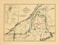
Map - Page 1 -From MAP/of the/VARIOUS LINES/BETWEEN/THE UNITED STATES AND/THE BRITISH PROVINCES/Reduced from the Official Map of/Major J.D.Graham U.S.Commissioner/Published by order of the Senate/March 3d.1843 Published by GRAHAM, MAJOR JAMES D. in 1846 |
 Buy this Map »


Map Information
Full Title: Map - Page 1 - MAP/of the/VARIOUS LINES/BETWEEN/THE UNITED STATES AND/THE BRITISH PROVINCES/Reduced from the Official Map of/Major J.D.Graham U.S.Commissioner/Published by order of the Senate/March 3d.1843
Full Atlas Title: MAP/of the/VARIOUS LINES/BETWEEN/THE UNITED STATES AND/THE BRITISH PROVINCES/Reduced from the Official Map of/Major J.D.Graham U.S.Commissioner/Published by order of the Senate/March 3d.1843
Location 1: Unattributed
Location 2: Maine, New Brunswick, Quebec
Publish Date: 1846
Publisher: GRAHAM, MAJOR JAMES D.
Number Maps in the Atlas: 1
Map Original Width: 18.34"
Map Original Height: 14.24"
Item Number: OL1453
Collection: Osher Map Library Antique Maps Collection
Image Quality: High quality scan of original that is perfect for printed fine-art quality reproduction.
Category:
Maps and/or Atlas Quality:
TAGS:
Full Atlas Title: MAP/of the/VARIOUS LINES/BETWEEN/THE UNITED STATES AND/THE BRITISH PROVINCES/Reduced from the Official Map of/Major J.D.Graham U.S.Commissioner/Published by order of the Senate/March 3d.1843
Location 1: Unattributed
Location 2: Maine, New Brunswick, Quebec
Publish Date: 1846
Publisher: GRAHAM, MAJOR JAMES D.
Number Maps in the Atlas: 1
Map Original Width: 18.34"
Map Original Height: 14.24"
Item Number: OL1453
Collection: Osher Map Library Antique Maps Collection
Image Quality: High quality scan of original that is perfect for printed fine-art quality reproduction.
Category:
antique maps, historic maps
Maps and/or Atlas Quality:
TAGS:
Source Institution:

Osher Map Library Smith Center For Cartographic Education
Souce Media:
Original Document
Osher Map Library Smith Center For Cartographic Education
Souce Media:
Original Document
| This antique map (Map - Page 1) and atlas (MAP/of the/VARIOUS LINES/BETWEEN/THE UNITED STATES AND/THE BRITISH PROVINCES/Reduced from the Official Map of/Major J.D.Graham U.S.Commissioner/Published by order of the Senate/March 3d.1843) are part of the Historic Map Works, Residential Genealogy™ historical map collection, the largest digital collection of rare, ancient, old, historical, cadastral and antiquarian maps of its type. We currently have over 1,662,956 images available online. You can read about the collection or browse the entire collection. |