
 Cart
Cart
|
ITEM #OL8016
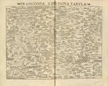
FRANCONIA XIIII NOVA TABULA 0346-00From GEOGRAPHIA VNIVERSALIS,VETUS ET NOVA,COMPLEDCTENS CLAVDII PTOLEMAEI Published by PTOLEMY, C. / MUNSTER, SEBASTIAN in 1545 |
 Buy this Map »
Map Information
Full Title: FRANCONIA XIIII NOVA TABULA 0346-00
Full Atlas Title: GEOGRAPHIA VNIVERSALIS,VETUS ET NOVA,COMPLEDCTENS CLAVDII PTOLEMAEI
Location 1: Europe
Location 2: Georgia
Publish Date: 1545
Publisher: PTOLEMY, C. / MUNSTER, SEBASTIAN
Number Maps in the Atlas: 535
Map Original Width: 14.72"
Map Original Height: 11.81"
Item Number: OL8016
Collection: Osher Map Library Antique Maps Collection
Image Quality: High quality scan of original that is perfect for printed fine-art quality reproduction.
Category:
Maps and/or Atlas Quality:
TAGS:
Full Atlas Title: GEOGRAPHIA VNIVERSALIS,VETUS ET NOVA,COMPLEDCTENS CLAVDII PTOLEMAEI
Location 1: Europe
Location 2: Georgia
Publish Date: 1545
Publisher: PTOLEMY, C. / MUNSTER, SEBASTIAN
Number Maps in the Atlas: 535
Map Original Width: 14.72"
Map Original Height: 11.81"
Item Number: OL8016
Collection: Osher Map Library Antique Maps Collection
Image Quality: High quality scan of original that is perfect for printed fine-art quality reproduction.
Category:
old maps, antique maps
Maps and/or Atlas Quality:
TAGS:
Source Institution:

Osher Map Library Smith Center For Cartographic Education
Souce Media:
Original Document
Osher Map Library Smith Center For Cartographic Education
Souce Media:
Original Document
| This antique map (FRANCONIA XIIII NOVA TABULA 0346-) and atlas (GEOGRAPHIA VNIVERSALIS,VETUS ET NOVA,COMPLEDCTENS CLAVDII PTOLEMAEI) are part of the Historic Map Works, Residential Genealogy™ historical map collection, the largest digital collection of rare, ancient, old, historical, cadastral and antiquarian maps of its type. We currently have over 1,662,956 images available online. You can read about the collection or browse the entire collection. |