
 Cart
Cart
|
ITEM #US1623877
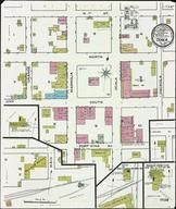
Sheet 001From Ocala 1886, Florida Published by Sanborn Map Company in 1886 |
 Buy this Map »
Image Title: Sheet 001 from UF Map Group Titled: Ocala, Marion County, Florida, 1886; Date: 1886; Publisher: Sanborn Map Company; UF Map Group Digital ID: UF00074208_00004; UF Image Digital ID: uf70000311n001
Map Information
Full Title: Sheet 001
Full Atlas Title: Ocala 1886
State: Florida
Location 1: Unattributed
Location 2: Unattributed
Publish Date: 1886
Publisher: Sanborn Map Company
Number Maps in the Atlas: 1
Map Original Width: 21.25"
Map Original Height: 25.28"
Item Number: US1623877
Collection: Historic Map Works Rare Historic Maps Collection
Image Quality: High quality scan of original that is perfect for printed fine-art quality reproduction.
Source Institution:

2011 © University of Florida, Gainesville, FL USA
Souce Media:
Original Document
2011 © University of Florida, Gainesville, FL USA
Souce Media:
Original Document
| This antique map (Sheet 001) and atlas (Ocala 1886) are part of the Historic Map Works, Residential Genealogy™ historical map collection, the largest digital collection of rare, ancient, old, historical, cadastral and antiquarian maps of its type. We currently have over 1,662,956 images available online. You can read about the collection or browse the entire collection. |