
 Cart
CartAddress Search
Results for "Latitude 37.96772, Longitude -87.678019"
View these maps overlayed on top of a modern map. You must be a member and logged in to use this feature.
Purchase a series of maps or images documenting the environmental or land use history of this location.
 A variety of printed products can be purchased by clicking on each individual map in the results below.
Click on any of the maps below to view a large, zoomable map.
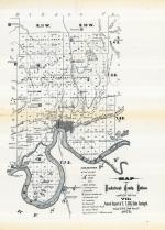 |
Vanderburgh County Map Vanderburgh County 1875 show address on this map |
E.T. Cox | 1875 |
 |
Vanderburgh County Indiana Counties 1876 show address on this map |
Baskin, Forster and Company | 1876 |
 |
Mississippi River 1807 - APSdigobj3545 Mississippi River 1807 show address on this map |
Nav, Anthony; Pike, Zebulon Montgomery, 1779-1813; Thompson; Lewis, M. | 1807 |
 |
Illinois State Map Madison County 1873 show address on this map |
Brink, McCormick & Co. | 1873 |
 |
Illinois State Map Mercer County 1874 show address on this map |
W. R. Brink & Co. | 1874 |
 |
Vanderburgh County Indiana State Atlas 1876 show address on this map |
Baskin, Forester and Company | 1876 |
 |
Indiana State Map Boone County 1878 show address on this map |
Kingman Brothers | 1878 |
 |
Indiana State Map Knox County 1880 show address on this map |
D. J. Lake & Co. | 1880 |
 |
Missouri Wells County 1881 show address on this map |
H.H. Hardesty | 1881 |
 |
United States Map Winnebago County and Boone County 1886 show address on this map |
H. R. Page & Co. | 1886 |
 |
Illinois State Map Mercer County 1892 show address on this map |
Alden, Ogle & Co. | 1892 |
 |
Land Survey of the United States Cass County 1893 show address on this map |
D.W. Ensign & Co. | 1893 |
 |
The World Map with Principal Cities of the Old World Fillmore County 1896 show address on this map |
Geo. A. Ogle & Co. | 1896 |
 |
United States Map Genesee County 1899 show address on this map |
Homer A. Day | 1899 |
 |
World Map Rooks County 1904 to 1905 show address on this map |
Geo. A. Ogle & Co. | 1904 |
 |
United States Map Waushara County 1906c show address on this map |
C.A. McIntyre and C.H. Terril | 1906c |
 |
Missouri State Map Laclede County 1912c show address on this map |
Western Publishing Company | 1912c |
 |
Illinois State Map Douglas County 1914 show address on this map |
Geo. A. Ogle & Co. | 1914 |
 |
World Map Guthrie County 1917c show address on this map |
Kenyon Company | 1917c |
 |
Missouri State Map Missouri State Atlas 1940c show address on this map |
W. W. Hixson & Company | 1940c |