
 Cart
CartAddress Search
Results for "Latitude 40.731146, Longitude -74.1712406"
View these maps overlayed on top of a modern map. You must be a member and logged in to use this feature.
Purchase a series of maps or images documenting the environmental or land use history of this location.
 A variety of printed products can be purchased by clicking on each individual map in the results below.
Click on any of the maps below to view a large, zoomable map.
 |
Ninth Ward Newark 1873 show address on this map |
G.M. Hopkins & Co. | 1873 |
 |
Page 010 - Newark - Wards 4, 5, 9, 10 and 12 Left Essex County 1881 show address on this map |
E. Robinson | 1881 |
 |
Plate 010 Newark 1889 show address on this map |
Scarlett & Scarlett | 1889 |
 |
Plate 002 Newark 1901 show address on this map |
E. Robinson & Comp. | 1901 |
 |
Plate 034 Newark 1912 Vol 2 show address on this map |
A. H. Mueller | 1912 |
 |
Plate 001 Newark 1927 Vol 3 show address on this map |
Elisha Robinson | 1927 |
 |
Newark New Jersey 1950c Nirenstein City Maps show address on this map |
Nirenstein | 1950 |
 |
Newark 1850 to 1859 - 01x142.3 Newark 1850 to 1859 - 01x142.3 show address on this map |
Charles Magnus | 1850-1859 |
 |
Index Map - Hudson County New Jersey State Atlas 1873 Jersey City and former Greenville Township show address on this map |
Hopkins, Griffith Morgan | 1873 |
 |
Topographic Sheet 003 - New Jersey - New York Staten Island Quadrangle New York City 1902 Geological Atlas of the United States Vol 83 show address on this map |
U.S. Geological Survey | 1902 |
 |
County Map and Index Essex County 1906 Vol 3 show address on this map |
A. H. Mueller & Co. | 1906 |
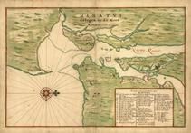 |
New York City 1639 Manatvs gelegen op de Noot Riuier New York City 1639 Manatvs gelegen op de Noot Riuier show address on this map |
Vinckeboons, Joan | 1639 |
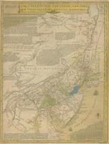 |
Pennsylvania, New Jersey, New York, Delaware 1749 - APSdigobj3524 Pennsylvania, New Jersey, New York, Delaware 1749 show address on this map |
Evans, Lewis, 1700?-1756 | 1749 |
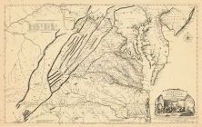 |
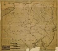
Virginia 1755 Map of the Most Inhabited part of Virginia etc Virginia 1755 Map of the Most Inhabited part of Virginia etc Created by Fry and Jefferson in 1751 show address on this map |
Joshua Fry and Peter Jefferson | 1755 |
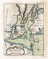 |
Bellin - New York - Baye et Port d'Yorc 1764 Bellin - New York - Baye et Port d'Yorc 1764 show address on this map |
Jacques-Nicolas Bellin | 1764 |
 |
New York Province 1779 Land Tracts new New York Province 1779 Land Tracts show address on this map |
Claude Joseph Sauthier | 1779 |
 |
Pennsylvania 1791c - APSdigobj3529 Pennsylvania 1791c show address on this map |
Adlum, John, 1759-1836; Wallis, John | 1791c |
 |
New Jersey 1793 - APSdigobj3457 New Jersey 1793 show address on this map |
Unattributed | 1793 |
 |
Pennsylvania 1807 including neighboring states - APSdigobj3463 Pennsylvania 1807 including neighboring states show address on this map |
Pursh, Frederick, 1774-1820 | 1807 |
 |
Essex County and Newark 1850 Wall Map 36x48 Essex County and Newark 1850 Wall Map show address on this map |
H. A. Belding | 1850 |
 |
New York, New Hampshire, Vermont 1864 Mitchell Plate New York, New Hampshire, Vermont 1864 Mitchell Plate show address on this map |
S. Augustus Mitchell | 1864 |
 |
Pennsylvania State Adams County 1872 show address on this map |
I. W. Field & Company | 1872 |
 |
Morris, Passaic and Bergen Counties Hudson County 1873 show address on this map |
G. M. Hopkins & Co. | 1873 |
 |
State Map - Connecticut Massachusetts Rhode Island Litchfield County 1874 show address on this map |
F. W. Beers & Co. | 1874 |
 |
New Jersey State Map Cumberland County 1876 show address on this map |
D. J. Stewart | 1876 |
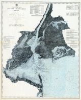 |
New York Bay and Harbor-Coast Guard Chart No. 20 New Jersey Coast 1878 show address on this map |
Woolman & Rose | 1878 |
 |
Pennsylvania Wells County 1881 show address on this map |
H.H. Hardesty | 1881 |
 |
St. Croix and Hudson Rivers and Lake Ontario Chart 1882 New England St. Croix and Hudson River and Lake Ontario Chart 1882 New England show address on this map |
U. S. Coastal Survey | 1882 |
 |
New England 1883 New England 1883 show address on this map |
Van Antwerp Bragg and Co. | 1883 |
 |
United States Map Winnebago County and Boone County 1886 show address on this map |
H. R. Page & Co. | 1886 |
 |
Bergen - Hudson - Essex 1887 to 1889 Topographic Map - APSdigobj3557_007 Bergen - Hudson - Essex 1887 to 1889 Topographic Map show address on this map |
Cook, George Hammell, 1818-1889; Smock, John C. (John Conover), 1842-1926; Vermeule, C. C. (Corneliu | 1887 to 1889 |
 |
Land Survey of the United States Cass County 1893 show address on this map |
D.W. Ensign & Co. | 1893 |
 |
The World Map with Principal Cities of the Old World Fillmore County 1896 show address on this map |
Geo. A. Ogle & Co. | 1896 |
 |
United States Map Genesee County 1899 show address on this map |
Homer A. Day | 1899 |
 |
World Map Rooks County 1904 to 1905 show address on this map |
Geo. A. Ogle & Co. | 1904 |
 |
United States Map Waushara County 1906c show address on this map |
C.A. McIntyre and C.H. Terril | 1906c |
 |
World Map Guthrie County 1917c show address on this map |
Kenyon Company | 1917c |
 |
Queens County, Nassau County - Map Pages Index Queens and Nassau Counties 1946 Long Island show address on this map |
Hagstrom Company | 1946 |
 |
Page 006 - New York Postal Delivery Zones New York City 1949 Five Boroughs Street Atlas show address on this map |
Hagstrom - Cruikshank Company | 1949 |
 |
Long Island 1xxx - APSdigobj3449 Long Island 1xxx show address on this map |
Henry, Mathew Schropp, 1790-1862 | Unattributed |