Click on any of the maps below to view a large, zoomable map.
 |
West Cleveland - Part 002, East Cleveland Township Allotments
Cuyahoga County 1892
show address on this map
|
Geo. F. Cram & Co. |
1892 |
 |
Plate 024
Cleveland 1898
show address on this map
|
A.H. Mueller |
1898 |
 |
Plate 003 - Cleveland Heights Village, Shaker Heights
Cuyahoga County 1914 Vol 3
show address on this map
|
G. M. Hopkins Co. |
1914 |
 |
Plate 007
Cleveland 1933 Revised 1942 Vol 3
show address on this map
|
G.M. Hopkins Co. |
1933 |
 |
Collinsville, East Clevland, Calhoun Allotment
Cuyahoga County 1874
show address on this map
|
Titus Simmons and Titus |
1874 |
 |
East Cleveland, Collinwood, Collamer, Glenville, Euclid Heights
Cuyahoga County 1892
show address on this map
|
Geo. F. Cram & Co. |
1892 |
 |
Plate 029
Cleveland 1898
show address on this map
|
A.H. Mueller |
1898 |
 |
Plate 124 - Cleveland Heights Village, Cedar Heights, Euclid Heights, Mayfield Heights - Right
Cuyahoga County 1903
show address on this map
|
H. P. Stranahan & Co. |
1903 |
 |
Plate 044 - Water System
Cleveland 1912 Revised 1920 Vol 2
show address on this map
|
G.M. Hopkins Co. |
1912 |
 |
Section 9
Cleveland and Cuyahoga County 1957
show address on this map
|
Commercial Survey Company |
1957 |
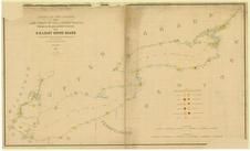 |
Lake Ontario - Lake Erie - Lake Champlain 1861 Lighthouse Charts - APSdigobj3543_001
Lake Ontario - Lake Erie - Lake Champlain 1861 Lighthouse Charts
show address on this map
|
Meade, George Gordon, 1815-1872 |
1861 |
 |
New York, New Hampshire, Vermont 1864 Mitchell Plate
New York, New Hampshire, Vermont 1864 Mitchell Plate
show address on this map
|
S. Augustus Mitchell |
1864 |
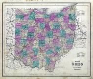 |
Ohio State Map
Wayne County 1873
show address on this map
|
J. A. Caldwell |
1873 |
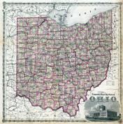 |
Ohio State Map
Hocking County 1876
show address on this map
|
Titus, Simmons & Titus |
1876 |
 |
British America
Wells County 1881
show address on this map
|
H.H. Hardesty |
1881 |
 |
United States Map
Winnebago County and Boone County 1886
show address on this map
|
H. R. Page & Co. |
1886 |
 |
Cuyahoga County Map
Cuyahoga County 1892
show address on this map
|
Geo. F. Cram & Co. |
1892 |
 |
Land Survey of the United States
Cass County 1893
show address on this map
|
D.W. Ensign & Co. |
1893 |
 |
The World Map with Principal Cities of the Old World
Fillmore County 1896
show address on this map
|
Geo. A. Ogle & Co. |
1896 |
 |
United States Map
Genesee County 1899
show address on this map
|
Homer A. Day |
1899 |
 |
World Map
Rooks County 1904 to 1905
show address on this map
|
Geo. A. Ogle & Co. |
1904 |
 |
United States Map
Waushara County 1906c
show address on this map
|
C.A. McIntyre and C.H. Terril |
1906c |
 |
Cuyahoga County
Ohio State Highway Maps 1910
show address on this map
|
State Highway Department of Ohio |
1910 |
 |
World Map
Guthrie County 1917c
show address on this map
|
Kenyon Company |
1917c |

 Cart
Cart A variety of printed products can be purchased by clicking on each individual map in the results below.