
 Cart
CartAddress Search
Results for "Latitude 44.9643048, Longitude -89.6392529"
View these maps overlayed on top of a modern map. You must be a member and logged in to use this feature.
Purchase a series of maps or images documenting the environmental or land use history of this location.
 A variety of printed products can be purchased by clicking on each individual map in the results below.
Click on any of the maps below to view a large, zoomable map.
 |
Maine - South Marathon County 1930 show address on this map |
Webb Publishing | 1930 |
 |
Lake Superior Kalamazoo County 1873 Published by F. W. Beers show address on this map |
F. W. Beers & Co. | 1873 |
 |
Wisconsin Railroad and Sectional Map Richland County 1874 show address on this map |
Harrison & Warner | 1874 |
 |
British America Wells County 1881 show address on this map |
H.H. Hardesty | 1881 |
 |
United States Map Winnebago County and Boone County 1886 show address on this map |
H. R. Page & Co. | 1886 |
 |
Land Survey of the United States Cass County 1893 show address on this map |
D.W. Ensign & Co. | 1893 |
 |
The World Map with Principal Cities of the Old World Fillmore County 1896 show address on this map |
Geo. A. Ogle & Co. | 1896 |
 |
United States Map Genesee County 1899 show address on this map |
Homer A. Day | 1899 |
 |
Marathon County Outline Map - Left Marathon County 1901 show address on this map |
Northwest Publishing Co. | 1901 |
 |
World Map Rooks County 1904 to 1905 show address on this map |
Geo. A. Ogle & Co. | 1904 |
 |
United States Map Waushara County 1906c show address on this map |
C.A. McIntyre and C.H. Terril | 1906c |
 |
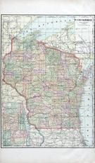
Wisconsin State Map Pierce County 1908 show address on this map |
Geo. A. Ogle & Co. | 1908 |
 |
Wisconsin State Map Fond Du Lac County 1910 show address on this map |
The Kenyon Company | 1910 |
 |
Wisconsin State Map Rock County 1917 show address on this map |
Hennessey & Co. | 1917 |
 |
World Map Guthrie County 1917c show address on this map |
Kenyon Company | 1917c |
 |
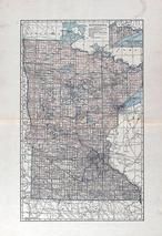
Minnesota County Outline Map Minnesota State Atlas 1925c show address on this map |
W. W. Hixson & Co. | 1925c |
 |
Minnesota State Map Yellow Medicine County 1929 show address on this map |
Webb Publishing Co. | 1929 |
 |
County Map Marathon County 1930 show address on this map |
Webb Publishing | 1930 |
 |
Wisconsin State Map Eau Claire County 1931 show address on this map |
Webb Publishing Co. | 1931 |
 |
Marathon County Map Wisconsin State Atlas 1933c show address on this map |
W.W. Hixson & Co. | 1933 |
 |
Marathon County Wisconsin State Atlas 1956 Highway Maps show address on this map |
Wisconsin Highway Commission | 1956 |
 |
Minnesota State Map Pennington and Red Lake Counties 1957 show address on this map |
K. R. Thompson Co. | 1957 |
 |
Minnesota State Map McLeod County 1963 show address on this map |
Thomas O. Nelson Co. | 1963 |