
 Cart
Cart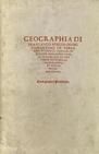
GEOGRAPHIA DI FRANCESCO BERLINGHIERI FIORENTINO IN TERZA RIMA ET LINGUA TOSCANA DI STINCTA CON LE SVE TAVO LE IN VARII SITI ET PRO VINCIE SECONDO LA GEOGRAPHIA ET DISTIN ctione dele tavole ei Ptolomeo
PTOLEMY, C. / BERLINGHIERI, F., 1482
Image Quality:
 High
High
A world atlas in Italian by Francesco Berlinghieri based on Claudius Ptolemy's Geographia or Geography in English. Ptolemy was a Greek geographer who lived around 150 A.D. in Alexandria, Egypt. His Geography described the extent of the known Greco-Roman world with a series of maps accompanied by descriptive text, corresponding charts, and coordinate tables.
Over time, original copies of Geography were lost to the Western world. Around the 13th century, editions of the work resurfaced and scholars began to rediscover its contents. Unfortunately, no maps from Ptolemy's original work survived to accompany the text, so subsequent authors and publishers of Geography were required to draw their own versions of the original maps using the information contained within the text and tables as their only guide. This rare book is Francesco Berlinghieri's 1482 Latin interpretation of Geography and it serves as an interesting reference to the other later editions of Geography to be found within the HMW Rare Book library.
Over time, original copies of Geography were lost to the Western world. Around the 13th century, editions of the work resurfaced and scholars began to rediscover its contents. Unfortunately, no maps from Ptolemy's original work survived to accompany the text, so subsequent authors and publishers of Geography were required to draw their own versions of the original maps using the information contained within the text and tables as their only guide. This rare book is Francesco Berlinghieri's 1482 Latin interpretation of Geography and it serves as an interesting reference to the other later editions of Geography to be found within the HMW Rare Book library.
Maps Blank Calibration Cover, Back inside Cover, Back outside Cover, Front inside Cover, Front outside OML Barcode Other Spine Text Title Page
 Indicates a map that is georeferenced


These antique maps and atlases are part of the Historic Map Works, Residential Genealogy™ historical map collection, the largest digital collection of rare, ancient, old, historical, cadastral and antiquarian maps of its type. Read about the collection. Browse entire collection.
Research Prints
All research prints will be printed with a light watermark.
Research Prints are color prints fitted to 11" x 17" paper ideal for research and educational use, but not suitable for framing as center seams and imperfections will not be removed. Orders for less than 15 research prints will be mailed folded in an envelope. Larger orders will be shipped flat via UPS.
All research prints will be printed with a light watermark.
Click here to see an example of a research print.
Research Prints are color prints fitted to 11" x 17" paper ideal for research and educational use, but not suitable for framing as center seams and imperfections will not be removed. Orders for less than 15 research prints will be mailed folded in an envelope. Larger orders will be shipped flat via UPS.