
 Cart
Cart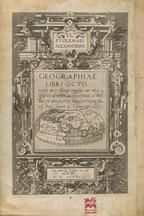
GEOGRAPHIAE LIBRI OCTO RECOGNITI IAM ET DILIGENTER EMENDATI CUM...
PTOLEMY, C. / MERCATOR, GERARD, 1584
Image Quality:
 High
High
Gerard Mercator's 1584 Latin edition of Ptolemy's Geography. Created towards the end of the celebrated Flemish cartographer's life, it is said that Mercator intended his version of Geography to be the most faithful interpretation ever published and unlike previously published editions it contained no maps of the new world. Mecator professed that other editions of Geography, with their inclusion of contemporary maps and knowledge unknown to second century geographers, had strayed too far from Ptolemy's original work. For comparison and analysis of how Mercator presented his interpretation, you may want to reference the 1482, 1541, and 1545 editions of Geography in the HMW Rare Book Library.
Maps Blank Calibration Cover, Back inside Cover, Back outside Cover, Front inside Cover, Front outside Illustration & Text OML Barcode Other Spine Text Title Page
 Indicates a map that is georeferenced

![AFR: IIII. TAB [ Northern Africa] 0206-00, GEOGRAPHIAE LIBRI OCTO RECOGNITI IAM ET DILIGENTER EMENDATI CUM...](/Images/Maps/OL/Bound/7341/web-7341-0206-00,final/TileGroup0/0-0-0.jpg "AFR: IIII. TAB [ Northern Africa] 0206-00, GEOGRAPHIAE LIBRI OCTO RECOGNITI IAM ET DILIGENTER EMENDATI CUM...")

![APPENDIX. III TABVLAE AFR: [EGYPT] 0202, GEOGRAPHIAE LIBRI OCTO RECOGNITI IAM ET DILIGENTER EMENDATI CUM...](/Images/Maps/OL/Bound/7341/web-7341-0202,final/TileGroup0/0-0-0.jpg "APPENDIX. III TABVLAE AFR: [EGYPT] 0202, GEOGRAPHIAE LIBRI OCTO RECOGNITI IAM ET DILIGENTER EMENDATI CUM...")


![EVROPAE I. TAB: [ALBION, BRITANNI, HIBERNIA] 0163-00, GEOGRAPHIAE LIBRI OCTO RECOGNITI IAM ET DILIGENTER EMENDATI CUM...](/Images/Maps/OL/Bound/7341/web-7341-0163-00,final/TileGroup0/0-0-0.jpg "EVROPAE I. TAB: [ALBION, BRITANNI, HIBERNIA] 0163-00, GEOGRAPHIAE LIBRI OCTO RECOGNITI IAM ET DILIGENTER EMENDATI CUM...")


These antique maps and atlases are part of the Historic Map Works, Residential Genealogy™ historical map collection, the largest digital collection of rare, ancient, old, historical, cadastral and antiquarian maps of its type. Read about the collection. Browse entire collection.
Research Prints
All research prints will be printed with a light watermark.
Research Prints are color prints fitted to 11" x 17" paper ideal for research and educational use, but not suitable for framing as center seams and imperfections will not be removed. Orders for less than 15 research prints will be mailed folded in an envelope. Larger orders will be shipped flat via UPS.
All research prints will be printed with a light watermark.
Click here to see an example of a research print.
Research Prints are color prints fitted to 11" x 17" paper ideal for research and educational use, but not suitable for framing as center seams and imperfections will not be removed. Orders for less than 15 research prints will be mailed folded in an envelope. Larger orders will be shipped flat via UPS.