British Columbia Historical Maps and Atlases
The state of British Columbia collection contains 0 atlases spanning 141 years of growth and development (1772 through 1913).
Within the atlases are 0 historical maps, illustrations, and histories many of which contain family names ideal for genealogical research. Others are rare antique maps, part of the collection by an exclusive arrangement with the Osher Map Library. The state of British Columbia has 10 of these antiquarian maps dating back as early as 1772.
|
Displaying 1- 1 of 1 in total
|
|
Click on a column header to sort table.
|
Name |
Attributes |
Quality |
Publisher |
State |
Date |
|
Name |
Atlas |
Attributes |
Publisher |
Date |
Collection |
 |
British Columbia |
World Atlas 1913 |
|
Rand McNally and Com... |
1913 |
HMW |
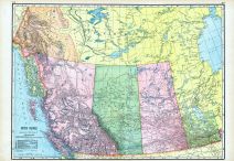 |
British Columbia, Northwest Te... |
World Maps 1906 from Wellingto... |
|
Historical Atlas Pub... |
1906 |
HMW |
 |
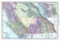
Map - Page 1 |
BRITISH COLUMBIA |
 |
CRAM, GEORGE F. |
1900 |
OML |
|
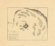 |
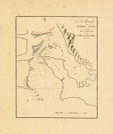
Map - Page 1 - A Plan/of/PORT ... |
A Plan/of/PORT EFFINGHAM/-in-/... |
|
MEARES, JOHN |
1790 |
OML |
|
 |
Map - Page 1 - A Sketch /of/PO... |
A Sketch /of/PORT COX/in the/D... |
|
MEARES, JOHN |
1790 |
OML |
|
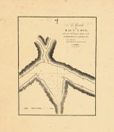 |
Map - Page 1 - A Sketch/of/RAF... |
A Sketch/of/RAFT - COVE,/taken... |
|
MEARES, JOHN |
1790 |
OML |
|
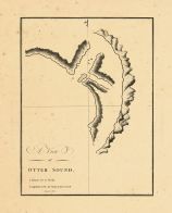 |
Map - Page 1 - A View/-of-/OTT... |
A View/-of-/OTTER SOUND. |
|
MEARES, JOHN |
1790 |
OML |
|
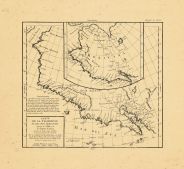 |
Map - Page 1 - CARTE/DE LA CAL... |
CARTE/DE LA CALIFORNIE/ET DES ... |
|
VAUGONDY, ROBERT de |
1772 |
OML |
|
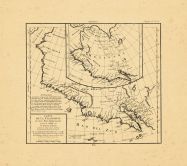 |
Map - Page 1 - CARTE/DE LA CAL... |
CARTE/DE LA CALIFORNIE/ET DES ... |
|
VAUGONDY, ROBERT de |
1772 |
OML |
|
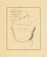 |
Map - Page 1 - Sketch of/FRIEN... |
Sketch of/FRIENDLY COVE/-in-/N... |
|
MEARES, JOHN |
1790 |
OML |
|
|
Displaying 1- 1 of 1 in total
|
|

 Cart
Cart